Skip to content
Maryland Weather

Everything you need to know about the weather in Maryland

  • Home
  • Blog Posts
    • Latest Posts
    • Archives
  • Forecasts
    • Local Forecasts
    • Forecast Discussion
  • Station Data
    • Current Data
  • Current Alerts
  • Radar Data
  • Maps & Satellite
    • WPC Maps
    • Satellite
  • Tropical
  • About
  • Subscribe!

light snow

Light snow tonight through tomorrow morning

Light snow tonight through tomorrow morning

An arctic front is pushing through today, bringing in much colder air. The front will settle to our south tonight and a weak area of low pressure will travel along…
Read More
Posted by By Billy DePriest Saturday, February 12, 2022Posted inAlert, Forecast
Period of light snow likely Saturday night into Sunday morning

Period of light snow likely Saturday night into Sunday morning

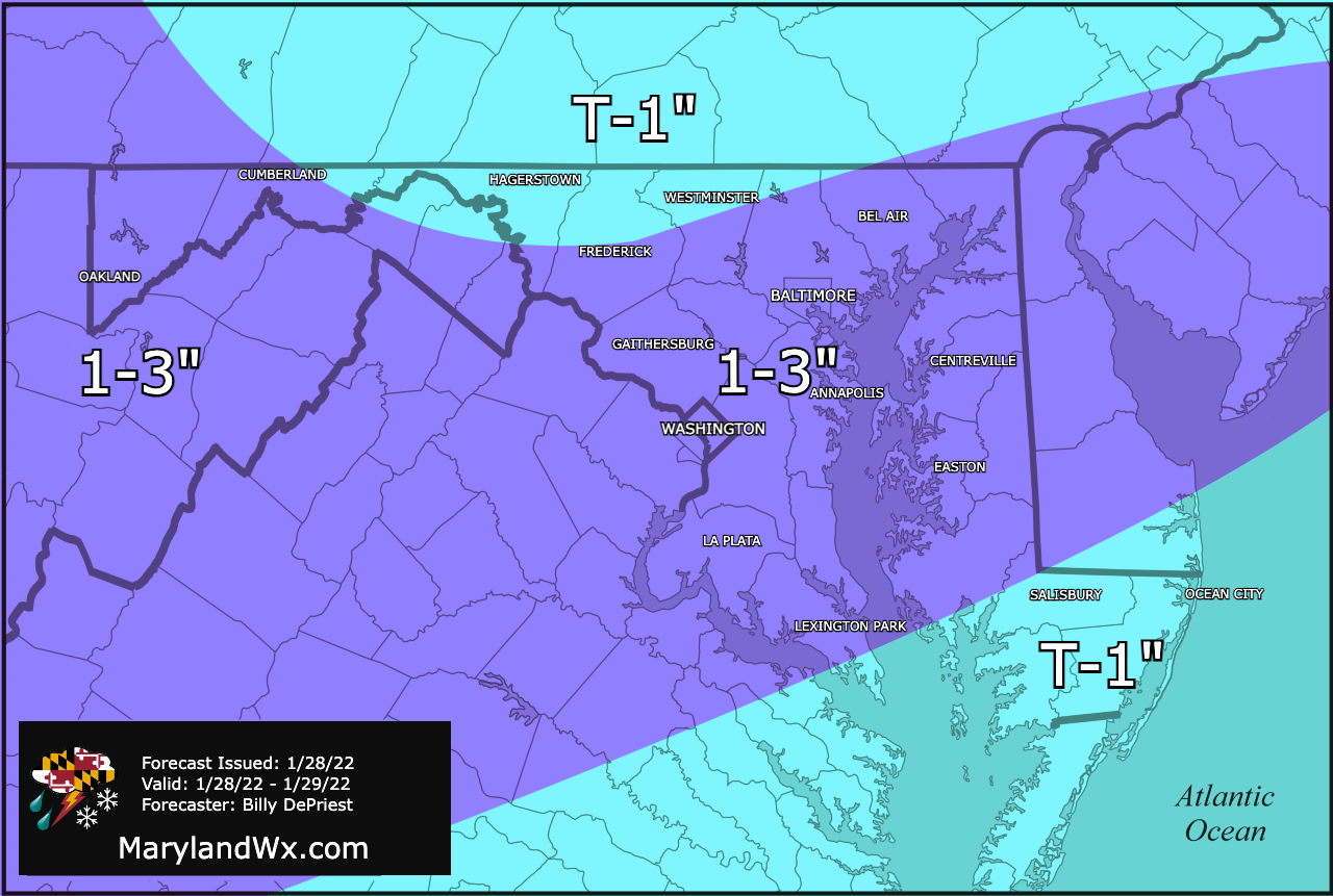
After several warm days, a cold front will cross the area late Saturday, setting the stage for a possible period of light snow late Saturday night into Sunday morning. Weak…
Read More
Posted by By Billy DePriest Thursday, February 10, 2022Posted inOutlook

Period of Snow Likely Tomorrow Morning

A quick moving area of low pressure is poised to move by to our north during the day tomorrow, bringing another round of precipitation to our state. We will be…
Read More
Posted by By Billy DePriest Sunday, February 21, 2021Posted inForecast

A Period of Light Snow is Likely Tomorrow

A weak area of low pressure will bring a period of slight snow to the state tomorrow. Expect light snow to spread from west to east during the late morning…
Read More
Posted by By Billy DePriest Thursday, March 7, 2019Posted inForecast

Light Snow/Mix Tonight into Tomorrow Morning

Summary: A weak low pressure will slide by to our south, bringing light precip to our area tonight and tomorrow morning. Expect light snow to break out around 1AM across…
Read More
Posted by By Billy DePriest Thursday, February 28, 2019Posted inAlert, Forecast

Light Snow Late Tomorrow into Sunday

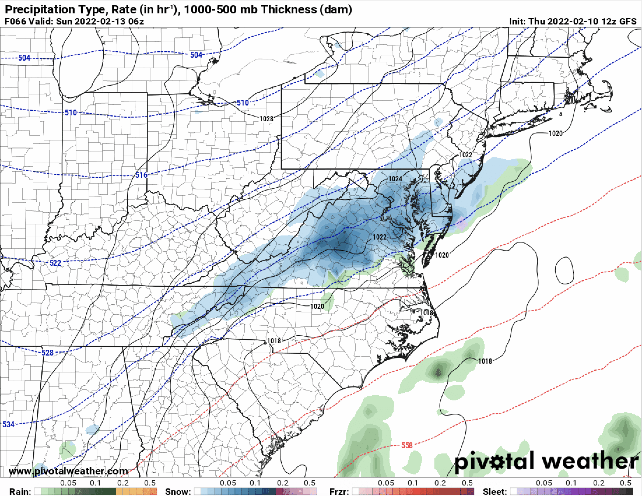
Summary: An area of low pressure will slide by to our south tomorrow night into Sunday. The system will intensify off the coast as it pulls away. An area of…
Read More
Posted by By Billy DePriest Friday, January 11, 2019Posted inForecast

Light Snow Overnight into Tomorrow Morning

An area of low pressure will move through our area tonight bringing light snow along with it. A Winter Weather Advisory has been issued for: Anne Arundel, Calvert, Caroline, Cecil,…
Read More
Posted by By Billy DePriest Sunday, January 29, 2017Posted inAlert, Forecast

Update on Tonight’s Snow & This Weekend’s System

The forecast for tonight's system remains on track, with an upper level disturbance poised to move through the area during the overnight hours. As it moves through, light snow is…
Read More
Posted by By Billy DePriest Thursday, January 5, 2017Posted inForecast

Light Snow Likely Tomorrow Night; Less Likely this Weekend

A cold front will pass through the state today, ushering in colder air on gusty northwest winds. Before it does, highs will top out in the low 50s but wind…
Read More
Posted by By Billy DePriest Wednesday, January 4, 2017Posted inForecast

Becoming Sunny Today through the Weekend; Chance of Snow Tuesday

Summary: Low pressure will pull away from the area today as high pressure builds in later today into tomorrow. Low pressure will move by to our southeast on Sunday while…
Read More
Posted by By Billy DePriest Friday, February 5, 2016Posted inForecast

Posts pagination

1 2 3 4 Next page
Current Conditions
Current Air Quality Index
Current Radar
Current Satellite
CPC 8-14 Day Temperature Outlook
CPC 8-14 Day Precipitation Outlook
CPC 1 Month Temperature Outlook
CPC 1 Month Precipitation Outlook
Email Subscription
Get the latest blogs emailed to you!


Instagram

maryland_wx

B.S. Meteorology @valparaiso_university | Skywarn Spotter | Providing weather info including forecasts and alerts for the state of Maryland.

🌬 As cold high pressure continues to settle ove 🌬 As cold high pressure continues to settle over the area, Frost and Freeze alerts have been issued for most of the state.

⚠️ A Freeze Warning is in effect for: Baltimore, Carroll, Frederick, and Harford counties...
* IMPACTS...Frost and freeze conditions will kill crops, other sensitive vegetation and possibly damage unprotected outdoor plumbing.

⚠️ A Frost Advisory is in effect for: Anne Arundel, Caroline, Cecil, Charles, Howard, Kent, Montgomery, Prince Georges, Queen Anne's, and Washington counties...
* IMPACTS...Frost could kill sensitive outdoor vegetation if left uncovered.

See https://www.marylandwx.com/alerts/ for more details.
Rainfall associated with Hurricane Ian has entered Rainfall associated with Hurricane Ian has entered southern portions of the state and will continue to move northward this evening. 

Expect periods of moderate to heavy rainfall tonight into early tomorrow morning before tapering to lighter showers through the day. Steadier rainfall may develop again on Sunday, lasting into Sunday evening as the remnant low spins off the coast.

Rainfall totals of 1-2" are likely by Monday morning.
A strong cold front will bring big changes to our A strong cold front will bring big changes to our weather, just in time for the autumnal equinox! The front will cross today with some showers. Behind it, gusty NW winds will bring in much cooler air. Lows tonight and tomorrow night will fall into the 40s for most areas. Highs tomorrow will only reach the mid 60s. Welcome to fall!
Follow on Instagram
Facebook
Cover for Maryland Weather
10,725
Maryland Weather

Maryland Weather

Weather conditions, forecasts, watches and warnings from the National Weather Service and other weather updates for the state of Maryland.

Operated by Billy DePriest


Affiliations
USA Weather Finder
Copyright 2025 — Maryland Weather. All rights reserved.
Scroll to Top