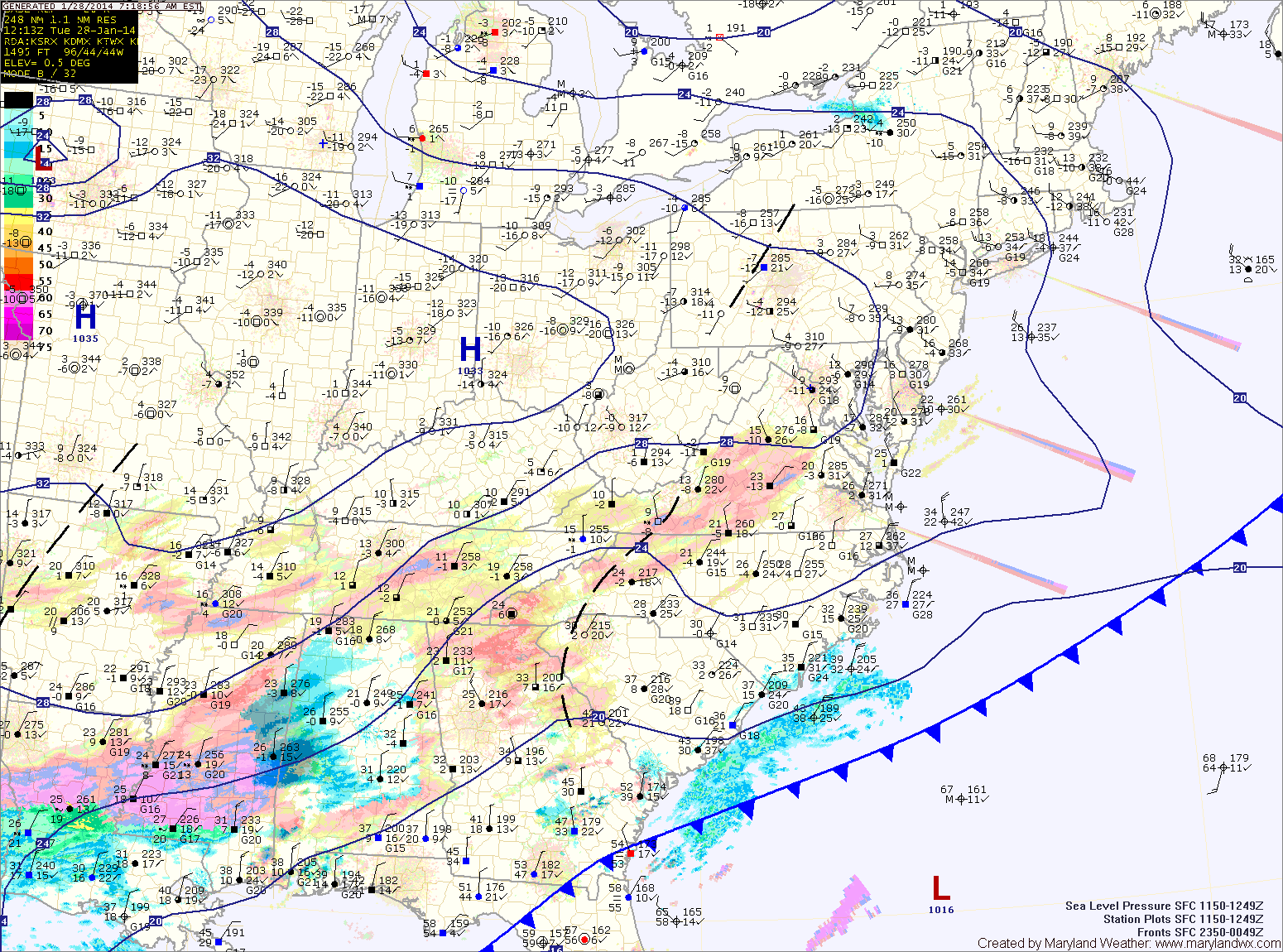
Mostly sunny today; Light snow likely tonight into tomorrow

Current Surface Map
Current Surface Map
As yesterday’s storm pushes away from the United States, sunshine will return and temperatures will warm to near 40 today, allowing for a good bit of melting of yesterday’s snow.

The departing storm dumped around 2 feet of snow in northern Baltimore, Carroll and Frederick, Howard and Montgomery counties.

Click here for a list of snow totals from the National Weather Service.

Here are a few notable reports (from 1:30am):

…ALLEGANY COUNTY…
FROSTBURG: 20.0
CUMBERLAND: 12.0

…ANNE ARUNDEL COUNTY…
1 E CROFTON: 10.0

…BALTIMORE COUNTY…
1 ESE GLYNDON: 26.0
OWINGS MILLS: 24.0
4 ENE REISTERSTOWN: 24.0
1 SSE TOWSON: 18.8
PARKVILLE: 16.5
CATONSVILLE: 14.0
2 E WHITE MARSH: 13.3

…BALTIMORE CITY…
PARK HEIGHTS: 17.1

…CALVERT COUNTY…
2 WNW HUNTINGTOWN: 5.4

…CARROLL COUNTY…
2 SE WESTMINSTER: 24.8
MOUNT AIRY: 17.0

…CHARLES COUNTY…
2 ESE BRYANS ROAD: 12.9
1 NNW ST. CHARLES: 12.0
1 S LA PLATA: 10.3

…FREDERICK COUNTY…
IJAMSVILLE: 20.3

…HARFORD COUNTY…
1 NNE BEL AIR: 17.5

…HOWARD COUNTY…
2 SE GAITHER: 22.0
2 SW SAVAGE: 20.5
2 NW COLUMBIA: 16.1

…MONTGOMERY COUNTY…
3 SSW DAMASCUS: 21.3
1 S OLNEY: 19.0
1 ENE GAITHERSBURG: 17.6
1 ESE TAKOMA PARK: 10.1

Going into tonight, a vigorous piece of energy and cold front will move to our south, bringing another chance of snow through tomorrow morning. This snow will be light, with a general 1-3″ possible across the state before it winds down by tomorrow afternoon. Highs tomorrow will be in the mid 30s with gusty northwest winds.

Sunday will be mostly sunny but cold, with highs around 30.

Mostly sunny today; Light snow likely tomorrow and Sunday

Current Surface Map
Current Surface Map
With high pressure in control, today will be mostly sunny with highs in the mid to upper 30s.

An area of low pressure will move by to our south tomorrow, spreading light snow showers into the area. A dusting to perhaps an inch is possible before it tapers off during the afternoon. Highs will be in the low to mid 30s.

Another round of light snow is possible on Sunday into Sunday night as a clipper-like system moves through. Highs will be in the mid 30s.

Partly sunny today and tomorrow; Light snow possible this weekend

Current Surface Map
Current Surface Map
High pressure is building into the region today, resulting in partly sunny skies with highs in the low to mid 30s.

Tomorrow will be similar to today, but a few degrees warmer with highs in the mid to upper 30s.

This weekend, we will be impacted by two separate areas of low pressure. At one point, it looked as those these two pieces of energy may phase and produce a significant storm along the east coast. Now, it appears the southern low will scoot by to our south and the northern low will move by without phasing. This will result in a chance of light snow Saturday into Sunday but nothing significant. Highs both days will be in the mid 30s.

Generally cloudy and cold today; Snow develops across south

Current Surface Map
Current Surface Map
Today will be generally cloudy and cold throughout the state as an area of low pressure develops over the deep south and moves towards the Carolina coast. Highs will top out around 20 degrees.

A Wind Chill Advisory is in effect through mid morning as wind chills drop to below 0 at times.

Widespread heavy snowfall is expected across most of Virginia and the Carolinas where up to a foot of snow may fall. We will be on the northern fringe of the storm here in Maryland. That said, lower southern Maryland and the lower eastern shore will likely see snow develop late this afternoon and into tonight. 1-2″ of snow is possible across St. Mary’s and Calvert counties while the eastern shore may see upwards of 4 inches.

A Winter Weather Advisory is in effect for the lower eastern shore, including Ocean City.

Cold stretch continues; Light snow likely tomorrow

Current Surface Map
Current Surface Map
Arctic air remains over the area today as high pressure builds in. Today will be mostly sunny with highs only reaching the upper teens to near 20 degrees.

A Wind Chill Advisory is in effect this morning for wind chills below zero.

Clouds will increase tonight as another clipper system approaches. The clipper will push through tomorrow bringing light snow to the area. Minor accumulations of a dusting to perhaps an inch are possible before the snow ends tomorrow evening.

It will be warmer than recent days with highs reaching the low 30s.

Light Snow Likely Tomorrow Night into Friday

Current Surface Map
Current Surface Map
A complicated setup will bring light snow to the area tomorrow evening into Friday morning.

A northern stream of energy currently over the midwest is sliding south and east towards the coast while a storm system is developing along the Gulf coast. These two pieces of energy will combine to form one low off the mid-atlantic coast. The combined storm will intensify as it moves northeastward and will likely bring blizzard-like conditions to areas of the northeast.

Here in Maryland, the storms will combine too far north to bring significant snowfall to the state. Current trends favor a light snowfall in the order of 1-3 or 2-4 inches with highest amounts in the northeast portion of the state.

Partly Sunny Today; Light Snow likely Tonight into Tomorrow

Current Surface Map
Current Surface Map
Expect more clouds than sun today with highs in the mid to upper 30s.

Tonight, a clipper system will approach from the west, bringing a swath of light snow through the area into tomorrow morning.

The precip will be light and totals of an inch or less are expected with the highest amounts near the Mason-Dixon line.

The snow should come to an end during the afternoon hours as westerly winds increase. Highs will be in the upper 30s.

High pressure builds in on Wednesday resulting in partly sunny skies and highs around 40.

Partly Sunny Today; Seasonable Conditions

Current Surface Map
Current Surface Map
A stationary front is draped across the state today, keeping clouds over the area. Highs will top out in the low to mid 40s.

Yet another clipper system moving by to our north will bring another chance of light snow or flurries, mainly in the mountains and across northern Maryland.

Tomorrow will be breezy with clearing skies. Highs will be in the mid 40s.

Expect more of the same on Thursday. Variably cloudy with highs in the mid 40s.

A low pressure system will bring a chance of rain or rain/snow mix Thursday night and Friday. Highs Friday will be in the mid to upper 40s.

Partly Sunny Start; More Light Snow This Evening

Current Surface Map
Current Surface Map
Today will begin under partly sunny skies, with clouds increasing through the day. A clipper system will bring light snow to the area this evening and tonight. Accumulations will be light, with totals under an inch.

The system is expected to stall near the area tomorrow, continuing a slight chance of light snow or mix as temperatures warm tomorrow afternoon. Highs will be near 40 tomorrow.

Another clipper will move through tomorrow night, continuing the chance of snow through tomorrow night.

Clearing Today; More Light Snow Tomorrow

Current Surface Map
Current Surface Map
As one over-performing storm departs, another will bring more snow to the area tomorrow. In between, expect a sunny but cold and windy day today. Highs will top out in the mid to upper 20s.

Last night’s clipper brought a dusting to northern parts of the state, while nearly 5 inches of snow fell across southern St. Mary’s county. Totals across central Maryland of 1-2″ were common.

The next system will have a bit more moisture with it, but will be a fast mover. Expect snow to develop during the afternoon and last into tomorrow night. Snowfall totals of 1-3″ are expected at this time, impacting the evening rush hour.

Behind that system, a cold and dry weekend is on tap. Highs on Saturday will push to near freezing, pushing into the mid 30s on Sunday.