Skip to content
Maryland Weather

Everything you need to know about the weather in Maryland

  • Home
  • Blog Posts
    • Latest Posts
    • Archives
  • Forecasts
    • Local Forecasts
    • Forecast Discussion
  • Station Data
    • Current Data
  • Current Alerts
  • Radar Data
  • Maps & Satellite
    • WPC Maps
    • Satellite
  • Tropical
  • About
  • Subscribe!

colder

Strong gusty winds likely tomorrow night into Friday

Strong gusty winds likely tomorrow night into Friday

A storm system with a strong cold front to our northwest will strengthen southerly flow today and tomorrow, pushing temperatures upward into the 50s and 60s. Showers are likely as…
Read More
Posted by By Billy DePriest Wednesday, February 16, 2022Posted inOutlook

Unseasonably Warm Today; Fall Returns this Weekend

With high pressure moving off of the east coast, southerly flow will usher warmer air into our region. Highs today will be in the mid to upper 60s. Major changes…
Read More
Posted by By Billy DePriest Friday, November 18, 2016Posted inForecast
Cold Front Will End Stretch of Warm Weather

Cold Front Will End Stretch of Warm Weather

A cold front is moving into the region today, spreading showers across the state as it does. The front will push into western portions of the state this morning, reaching…
Read More
Posted by By Billy DePriest Friday, October 21, 2016Posted inForecast

Warm with Scattered Showers and Thunderstorms Today; More Showers Tomorrow, then Colder

Summary: A cold front will push through today. Another front will move through tomorrow. High pressure builds in Sunday before another system moves in Monday. Areas of showers and thunderstorms…
Read More
Posted by By Billy DePriest Friday, April 1, 2016Posted inForecast

Rain to Snow this Evening; Snow Tomorrow into Tomorrow Night

Summary: An area of low pressure will impact our area tonight through tomorrow night. High pressure returns late Wednesday through the weekend. Low pressure will move into the area later…
Read More
Posted by By Billy DePriest Monday, February 8, 2016Posted inAlert, Forecast

First Call Snow Forecast – Tuesday into Wednesday

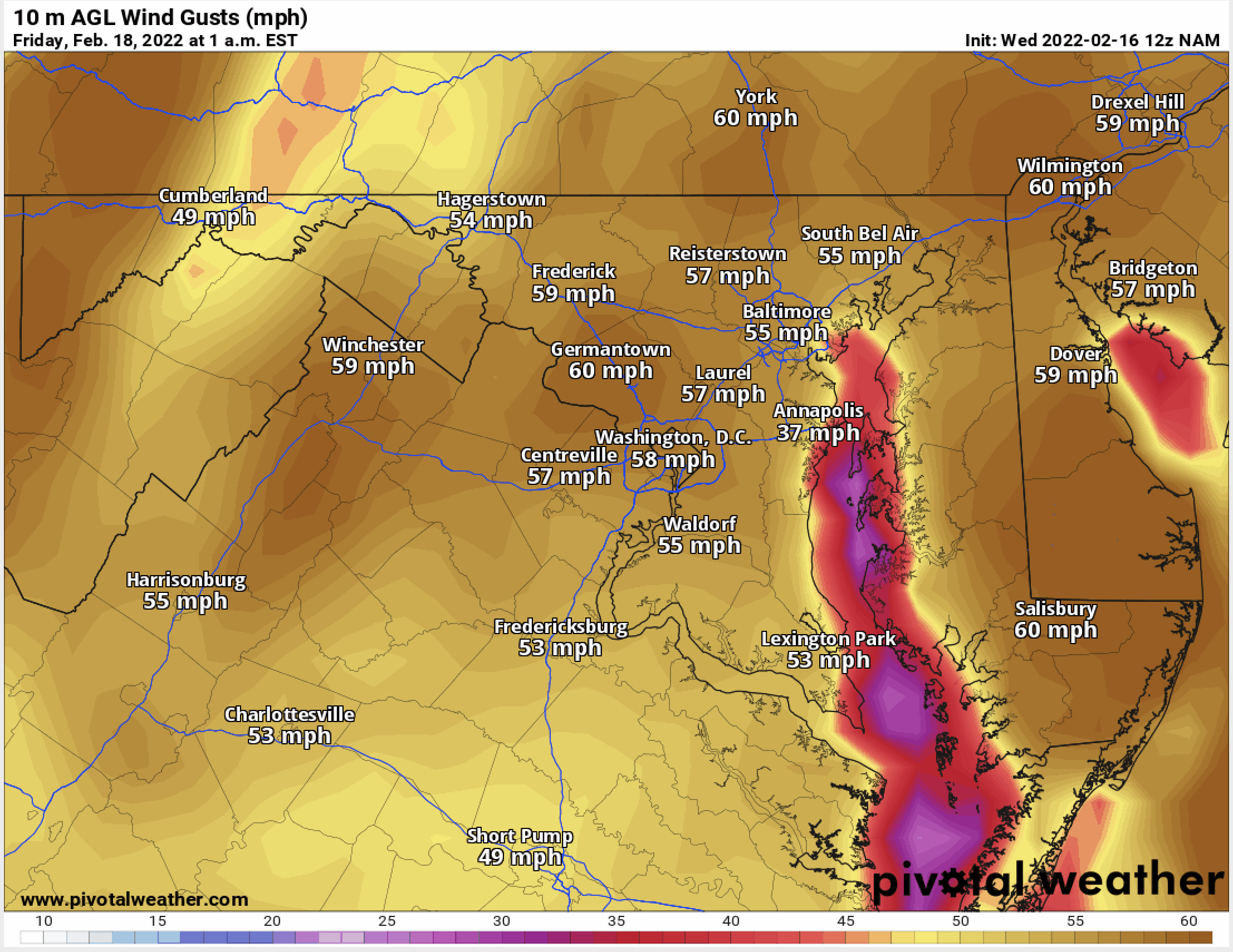
Summary: An area of low pressure will impact our area tomorrow through Tuesday before moving away from the area on Wednesday. Cold high pressure will build in behind the system,…
Read More
Posted by By Billy DePriest Sunday, February 7, 2016Posted inForecast

Colder and Breezy Today; Flurries Likely Late Tomorrow

Summary: High pressure is building into our area today. A cold front will push through tomorrow, followed by high pressure for Wednesday and Thursday. A storm system will likely affect…
Read More
Posted by By Billy DePriest Monday, January 11, 2016Posted inForecast

Drying Out and Turning Colder

Summary: Cool high pressure is building into the region today. The high will persist through the weekend. A reinforcing cold front will move through late Monday into Tuesday. A cold…
Read More
Posted by By Billy DePriest Thursday, December 31, 2015Posted inForecast

Showers Likely into This Afternoon; Breezy and Sunny into The Weekend

Summary: A cold front will slide through the area today followed by high pressure tomorrow. High pressure will remain in control through Saturday before another cold front moves through the…
Read More
Posted by By Billy DePriest Thursday, November 19, 2015Posted inForecast

Breezy and Cooler Today with a Chance of Sprinkles this Afternoon

An area of low pressure remains over the northeast US and will continue to combine with building high pressure to funnel cooler air into our region on gusty northwest winds.…
Read More
Posted by By Billy DePriest Thursday, April 23, 2015Posted inAlert, Forecast

Posts pagination

1 2 3 … 7 Next page
Current Conditions
Current Air Quality Index
Current Radar
Current Satellite
CPC 8-14 Day Temperature Outlook
CPC 8-14 Day Precipitation Outlook
CPC 1 Month Temperature Outlook
CPC 1 Month Precipitation Outlook
Email Subscription
Get the latest blogs emailed to you!


Instagram

maryland_wx

B.S. Meteorology @valparaiso_university | Skywarn Spotter | Providing weather info including forecasts and alerts for the state of Maryland.

🌬 As cold high pressure continues to settle ove 🌬 As cold high pressure continues to settle over the area, Frost and Freeze alerts have been issued for most of the state.

⚠️ A Freeze Warning is in effect for: Baltimore, Carroll, Frederick, and Harford counties...
* IMPACTS...Frost and freeze conditions will kill crops, other sensitive vegetation and possibly damage unprotected outdoor plumbing.

⚠️ A Frost Advisory is in effect for: Anne Arundel, Caroline, Cecil, Charles, Howard, Kent, Montgomery, Prince Georges, Queen Anne's, and Washington counties...
* IMPACTS...Frost could kill sensitive outdoor vegetation if left uncovered.

See https://www.marylandwx.com/alerts/ for more details.
Rainfall associated with Hurricane Ian has entered Rainfall associated with Hurricane Ian has entered southern portions of the state and will continue to move northward this evening. 

Expect periods of moderate to heavy rainfall tonight into early tomorrow morning before tapering to lighter showers through the day. Steadier rainfall may develop again on Sunday, lasting into Sunday evening as the remnant low spins off the coast.

Rainfall totals of 1-2" are likely by Monday morning.
A strong cold front will bring big changes to our A strong cold front will bring big changes to our weather, just in time for the autumnal equinox! The front will cross today with some showers. Behind it, gusty NW winds will bring in much cooler air. Lows tonight and tomorrow night will fall into the 40s for most areas. Highs tomorrow will only reach the mid 60s. Welcome to fall!
Follow on Instagram
Facebook
Cover for Maryland Weather
10,725
Maryland Weather

Maryland Weather

Weather conditions, forecasts, watches and warnings from the National Weather Service and other weather updates for the state of Maryland.

Operated by Billy DePriest


Affiliations
USA Weather Finder
Copyright 2025 — Maryland Weather. All rights reserved.
Scroll to Top