Tomorrow Morning
Summary:
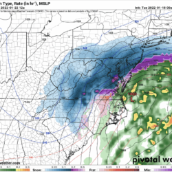
- A cold front will push through late tonight into tomorrow morning. Light rain along the front tonight will changeover to a period of snow before ending tomorrow.
Timing:
- Changeover is likely to occur around 4AM, with several hours of snow likely. Ending from north to south from mid-morning to early afternoon.
GFS Model Projected Timing:

Impacts:
- Falling temps and falling, accumulating snow will likely cause slick spots and impact the morning commute.
- Light rain falling prior to the changeover will likely impact effectiveness of any pre-treatment of roadways.
Snowfall Forecast:
- 1-3″ across most of the state, with highest amounts likely across north-central MD, and lowest amounts across southern MD and the lower Eastern Shore.
Forecast Confidence: MED/HIGH
Friday Night – Saturday
Summary:
The European model has completely trended to the GFS solution, with a weaker and more southern system. At this time, there is very little impact expected for our area.
Timing:
Late Friday into Saturday
Impacts:
No impacts are expected at this time
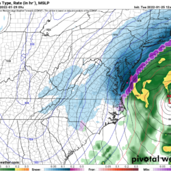
European Model Trend Loop:

As you can see above, the first several runs of the European show a major snowstorm over our area, but subsequent runs show a progression to a weaker and further south and east solution. It looks like, once again this winter, the GFS has outperformed the European model.
Forecast Confidence: MED/HIGH