
Everything remains on track for the most significant snowfall we have seen in several years to begin tomorrow morning. The National Weather Service has issued Winter Storm Warnings, and snow is expected to move into the region from the SW over the morning hours, continuing through the day as the storm system dies out over the Midwest. After a lull tomorrow night, additional snowfall is likely starting early Monday morning as a new system develops along the eastern seaboard.
There is high confidence that several inches of snow will fall during the day tomorrow, while the secondary snowfall remains less certain, and will be completely dependent on where and when the coastal system takes over, it’s path, and how quickly it moves up the coast. One additional complication is the likelihood that areas along and east of I-95 will see a period of mixed precipitation, or even rain tomorrow night before the secondary system takes over and changes the precip back to snow. My current thinking is that the snow will continue into Monday, before winding down late Monday, or Monday night as the coastal pulls away from the area.
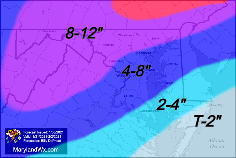
As a result of the latest information, I have slightly adjusted my forecast, but my overall thoughts remain the same. If the coastal system brings very little snow, totals will be in the low end of my ranges. Conversely, if the coastal forms further south, becomes stronger quicker, and/or moves slower, snow totals would increase, and possibly exceed the top end of my ranges. All said, regardless of the impact from the coastal system, we should still see a significant snowfall, with snow totals not seen in several years.