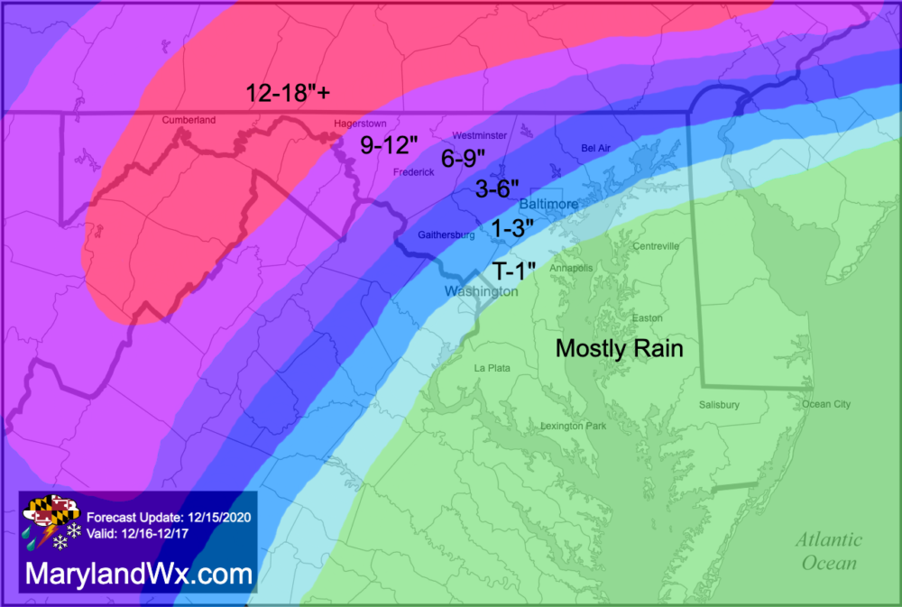
A trend in the models that started yesterday has continued today, with a storm track further west, and as a result, warmer air pushing further west than what was modeled yesterday. This will push the rain/snow line further west, and cut down on snow totals across a fair amount of the state. Fortunately, the main precipitation types will be snow, sleet, and rain, with very little freezing rain, so major ice accumulation is not expected.
Right now, it looks like precipitation will overrun the state during the late morning and afternoon hours, mostly as snow. Some snow accumulation is likely before the changeover begins for areas along and east of I-95. This area will likely see minimal snow, before a change to sleet then rain. A Flood Watch has been issued for Anne Arundel, Calvert, Charles, Prince George’s and St. Mary’s counties where periods of moderate rainfall may cause some flooding. The rain may mix back with or change over to a period of snow before ending early Thursday morning, with minimal additional accumulations.
As you move north and west of I-95, Winter Storm Watches and Warnings are in effect as snowfall totals will increase dramatically as the mixing and changeover threat decreases. That said, even areas out to near Frederick will likely see mixing or a change to sleet for a time as well, before changing back to a period of snow Wednesday night. West of there should remain all snow with significant snowfall expected.
My latest forecast map follows. This reflects my current thinking, after reviewing the last 24 hours of data. I will continue to monitor the situation and will post another update tomorrow if needed, but this may very well be my final forecast for this event.