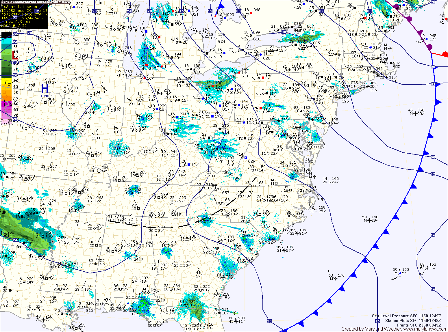
Mostly Sunny Today; Wintry Mix Develops Tomorrow

Current Surface Map
Current Surface Map
High pressure will build overhead today, providing another mostly sunny day. Highs will be in the upper 30s to near 40. It will continue to be breezy, with northwest winds gusting to around 20mph.

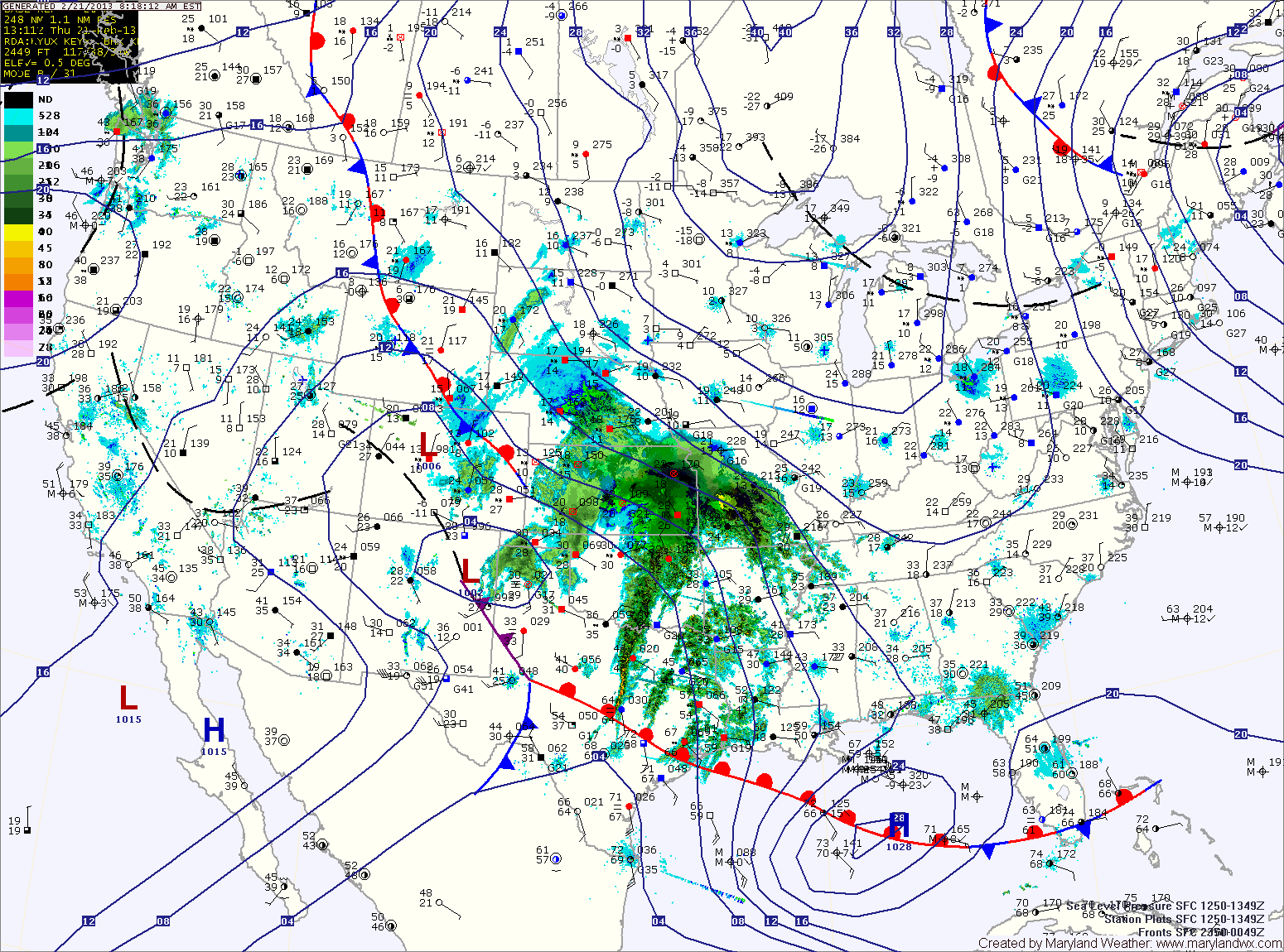
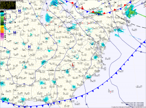
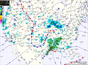
Clouds will begin to increase tonight as an area of low pressure approaches from the southwest.

Expect a wintry mix of snow, sleet and freezing rain to develop by tomorrow afternoon. The light mix will continue into tomorrow night before slowly transitioning to plain rain during the overnight. Highs tomorrow will only top out in the mid 30s.

A secondary low is expected to develop along the coast, keeping rain in the forecast for Saturday. Highs on Saturday will be around 40.

Windy Today and Tomorrow; Wintry Mix to Rain Friday

Current Surface Map
Current Surface Map
High pressure building into the region today will bring sunshine and breezy conditions through tomorrow. Winds may gust to near 30mph at times both days. Highs will be in the mid to upper 30s both days.

Clouds will increase tomorrow night ahead of the next storm system to affect our area.

An area of low pressure will approach from the southwest. Meanwhile, high pressure over eastern Canada will funnel cold air down the east coast.

This wedge of cold air will set the stage for a wintry mix of precipitation Friday afternoon, changing to rain by Friday evening. Highs Friday will top out in the mid 30s.

Rain Today; Windy through Thursday

Current Surface Map
Current Surface Map
A cold front is moving towards the area and bringing a swath of rainfall with it. Rain, with isolated areas of freezing rain is currently falling across western Maryland where a Winter Weather Advisory is in effect until 11am. By that time, temperatures will be above freezing everywhere and just plain rain is expected.

The rain will continue to move eastward through the day, spreading into central Maryland by late morning. Highs today will be in the upper 40s.

Rain will continue to fall into this evening, as the front pushes through. Behind the front, winds will increase tonight, gusting to near 30mph.

Sunny Today; Rain Tomorrow

Current Surface Map
Current Surface Map
High pressure sliding off the coast will provide sunny skies today with high temperatures near 40 degrees.

Clouds increase tonight as a cold front approaches from the west. The front will bring rain to the area tomorrow. The rain could start as sleet or freezing rain, especially north and west of I-95. Any frozen precip will be light and will change over to rain by late morning. Highs will be in the upper 40s.

The front clears the state tomorrow evening, bringing an end to the rainfall. Behind the front, gusty northwest winds will develop tomorrow night and Wednesday.

Rain Today, Possibly Ending as Snow Tonight

Current Surface Map
Current Surface Map
An area of low pressure continues to develop into a powerful Nor’Easter off the Carolina coast. As it moves northeast, it will continue to spread rain, sleet and snow over our area and will bring heavy snow and blizzard conditions to New England.

A Winter Weather Advisory remains in effect for counties north and west of I-95. These areas will gradually transition to rain today as highs top out around 40 degrees.

As the storm moves northeast and phases with a secondary low currently over Ohio, it will strengthen rapidly and as it does, colder air will be pulled into our area, possibly changing the rain to snow before ending tonight.

Accumulations of up to an inch are possible, especially over northeast Maryland. Additionally, winds will increase tonight and will gust to near 40mph at times.

Mostly Sunny Today; Mix to Rain Friday

Current Surface Map
Current Surface Map
Today will be mostly sunny and breezy with a high in the low 40s. Northwest winds will gust to near 25mph this afternoon.

Tomorrow will feature increasing clouds, with a high in the upper 30s to around 40.

An area of low pressure developing over eastern Texas will move along the Gulf Coast and then up the coast Friday. With a lack of cold air, expect light rain or wintry mix to develop late Thursday night, changing to rain.

The rain will continue Friday into Friday night. Highs Friday will be in the mid 40s.

As the storm moves up the coast, major snowfall is expected to our north into New England.

Wintry Mix Transitioning to Rain

Current Surface Map
Current Surface Map
Areas of sleet and freezing rain will continue to change to plain rain as we move through this morning. Temperatures across Central Maryland are around freezing at this time and will continue to rise. North and west of the cities, temperatures are a bit colder and will take a little longer to warm up.

All areas east of the mountains should be safely above freezing by noon.

Shower chances will continue this afternoon and into tonight.

Tomorrow we will be between storm systems as a warm front slowly pushes north of the state. Temperatures will warm into the low 50s under partly sunny skies.

A strong cold front will approach on Wednesday. Out ahead of it, temperatures will approach 60 degrees in most areas. The front will bring rain and even thunderstorms to the area Wednesday into Wednesday night. Some of the storms could be strong to severe, with damaging winds the main threat.

Very Cold and Windy; Chance of Wintry Precip on Friday

Current Surface Map
Current Surface Map
Following a cold frontal passage yesterday, bitterly cold air has spilled into the region on strong northwest winds. Highs today will struggle into the mid 20s while wind gusts to 30mph will make it feel like it is in the teens.

Tonight will see temperatures drop into the low teens for lows, warming to the mid 20s for highs again tomorrow.

There is a slight chance of light snow, with little to no accumulation tomorrow night as a weak system passes through.

A return to sunshine on Thursday, with highs in the upper 20s to near 30.

Light Snow Expected Tomorrow

Current Surface Map
Current Surface Map

A fast moving area of low pressure will bring light snow to the area tomorrow.

The low is currently over eastern Texas and it will quickly move by to our south during the day tomorrow before it strengthens and moves towards New England.

Expect light snow to develop during the pre-dawn hours tomorrow morning, mixing with or changing to rain in southern Maryland and the lower Eastern Shore.

The rain/snow line will approach the I-95 corridor by tomorrow afternoon and may push into the Baltimore/Washington metro areas.

Winter Weather Advisory in effect

The entire state west of the Bay is under a Winter Weather Advisory for snow, sleet and freezing rain.

Garrett County is expected to see more accumulation of snow and ice, and is under a Winter Storm Warning.

Expect snow and sleet to develop after 10pm in most areas, changing to all sleet overnight.