Increasing Clouds Today; Heavy Snow Tomorrow

Current Surface Map
Current Surface Map
The biggest snowstorm in over 2 years will affect the area tonight and tomorrow. Today will feature increasing clouds with highs in the low to mid 40s.

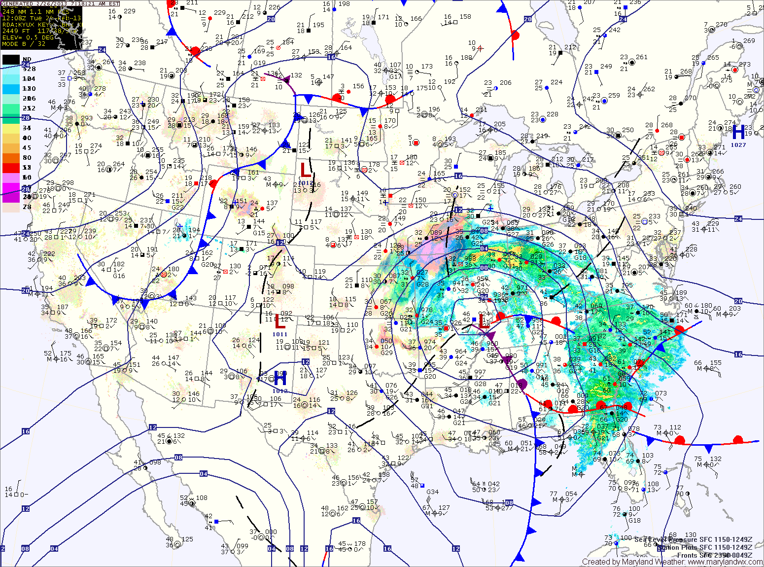
Currently, a Winter Storm Warning is in effect for Allegany, Frederick, Garrett and Washington counties. A Winter Storm Watch remains in effect for the rest of the state west of the Bay.

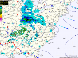
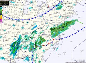
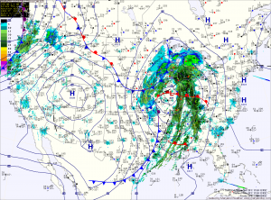
Precipitation will overspread the state from west to east this afternoon and evening. In the mountains, it will start as snow, while further east, rain will develop and slowly transition to snow during the overnight.

By tomorrow morning, all areas west of the Bay will have transitioned to snow. Areas around and east of I-95 may mix with rain at times tomorrow morning, but the snow will continue, heavy at times through the day and into tomorrow night. Lower southern Maryland and the Eastern Shore will see more rain and have more mixing, cutting down storm totals. By tomorrow night, even these areas will see a period of all snow before it begins to taper off.

Rain Today; Light Rain/Snow Showers Tomorrow and Thursday

Current Surface Map
Current Surface Map
Low pressure will move into the area today, bringing rain to the state. Across far western Maryland, temperatures will remain cold enough for freezing rain and a Winter Storm Warning is in effect for Garrett and Allegany counties for significant icing.

Further east, a Winter Weather Advisory is in effect for Washington county where a changeover to rain is expected this afternoon.

Even further east, expect rain to develop later this morning, possibly starting as a brief period of sleet. The rain will be steady through the day and into tonight.

A Flood Watch is in effect for the central part of the state, where around an inch of rainfall is expected.

Light Snow Develops This Afternoon

Current Surface Map
Current Surface Map
A Winter Weather Advisory is in effect for all of Maryland, except for Garrett County, where a Winter Storm Warning is in effect.

A weak storm system will spread light snow over the state this afternoon from west to east. 4-6 inches of snow are expected over Garrett County, while 1-3 inches are expected within the Advisory areas.

There could be isolated higher amounts, especially across northern Maryland and Southern Maryland.

The snow will begin to wind down tonight, tapering to flurries and ending between 10pm and midnight.

Heavy Snow South

Current Surface Map
Current Surface Map
As mentioned yesterday, the low pressure that will bring snow to the area today and tonight will have a sharp dropoff of precipitation on the northern edge. As such, some areas will see flurries while others receive several inches of snow over a relatively short distance.

It appears that dividing line will setup across central Maryland today. Areas north of Baltimore will see little to no accumulation while in the counties to the south of the city, a Winter Weather Advisory is in effect for 1-3 inches of snow with the highest amounts the further south you go.

Strong Cold Front Brings Rain and Wind

Current Surface Map
Current Surface Map
An intense area of low pressure continues to strengthen over the midwest while it drags a cold front across the country. The front will approach the area this afternoon spreading rain into the area by sunset.

The rain will be heavy at times, accompanied with strong gusty winds. A thunderstorm is possible during the overnight as well.

Winter begins at 6:12 tomorrow morning and the front will be pushing through around that time. Expect wind gusts to near 40mph tomorrow, as temperatures fall from the low 40s into the 30s during the day.

Winter Weather Advisory in effect

The entire state west of the Bay is under a Winter Weather Advisory for snow, sleet and freezing rain.

Garrett County is expected to see more accumulation of snow and ice, and is under a Winter Storm Warning.

Expect snow and sleet to develop after 10pm in most areas, changing to all sleet overnight.

Winter Storm Warning

UPDATED 2:45pm: NWS:  5 to 8" now expected across Northern Maryland... 4 to 8" now expected across Central Maryland... MDZ003>007-501-502-VAZ028-WVZ050>053-055-501>504-220100- /O.UPG.KLWX.WS.A.0004.110222T0200Z-110222T1200Z/ /O.NEW.KLWX.WS.W.0004.110222T0000Z-110222T1200Z/ WASHINGTON-FREDERICK MD-CARROLL-NORTHERN BALTIMORE-HARFORD- EXTREME WESTERN ALLEGANY-CENTRAL AND EASTERN…

1/26/11: Storm Update

Everything continues to unfold about as expected... the NWS has expanded the Winter Storm Warning back to the east to include the central Maryland counties that were previously under an…

2/8/10: Outlook – Winter Storm Warning

WWUS41 KLWX 082004WSWLWXURGENT - WINTER WEATHER MESSAGENATIONAL WEATHER SERVICE BALTIMORE MD/WASHINGTON DC304 PM EST MON FEB 8 2010DCZ001-MDZ003>007-009>011-013-014-VAZ042-053-054-WVZ053-090415-/O.UPG.KLWX.WS.A.0005.100209T1700Z-100211T0000Z//O.NEW.KLWX.WS.W.0007.100209T1700Z-100211T0000Z/DISTRICT OF COLUMBIA-WASHINGTON-FREDERICK MD-CARROLL-NORTHERN BALTIMORE-HARFORD-MONTGOMERY-HOWARD-SOUTHERN BALTIMORE-PRINCE GEORGES-ANNE ARUNDEL-LOUDOUN-FAIRFAX-ARLINGTON/FALLS CHURCH/ALEXANDRIA-JEFFERSON-INCLUDING THE CITIES OF...WASHINGTON...HAGERSTOWN...FREDERICK... WESTMINSTER...GAITHERSBURG...COLUMBIA...BALTIMORE...ANNAPOLIS...LEESBURG...FAIRFAX...ALEXANDRIA...FALLS…