A Winter Storm Watch has been issued for tomorrow night and Thursday. High pressure continues to control our weather, keeping things calm and clear through today. Afternoon highs will top…
WWUS41 KLWX 101954 WSWLWX URGENT - WINTER WEATHER MESSAGE NATIONAL WEATHER SERVICE BALTIMORE MD/WASHINGTON DC 254 PM EST MON FEB 10 2014 DCZ001-MDZ006-007-009>011-013-014-016>018-VAZ052>057-110400- /O.NEW.KLWX.WS.A.0004.140213T0000Z-140214T0300Z/ DISTRICT OF COLUMBIA-NORTHERN BALTIMORE-HARFORD-MONTGOMERY-HOWARD- SOUTHERN BALTIMORE-PRINCE…
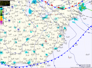
Current Surface MapThe next in a series of storms will approach today. This storm will pass by to our west, putting us on the warm side of the system. As the storm moves in and warmer air moves in aloft, cold air will be trapped at the surface east of the mountains. This will result in a wintry mix of precipitation tonight into tomorrow.
Along northern and western Maryland, a Winter Storm Warning has been issued. Expect snow to develop this evening, changing to sleet and then freezing rain. The freezing rain will likely last through the morning before temperatures warm above freezing tomorrow afternoon. Several inches of snow and sleet may fall, followed by up to 1/3 inch of ice from freezing rain.
Further south, into central Maryland, a Freezing Rain Advisory has been issued. Expect snow and sleet to develop this evening and change to freezing rain later tonight. Up to 1/10 inch of ice is possible before temperatures rise above freezing tomorrow morning, changing the freezing rain to plain rain.
Southern Maryland and the lower eastern shore will quickly rise above freezing and see mostly rain.
Current Surface MapHigh pressure will provide a mostly sunny day today with highs in the mid to upper 30s.
The high will move off the coast later today as an area of low pressure approaches from the southwest. The low will spread precipitation into the area tomorrow morning likely in the form of snow.
The snow will change to sleet during the afternoon and then eventually to rain by the evening along and east of I-95. This area may see up to an inch of snow before changing over.
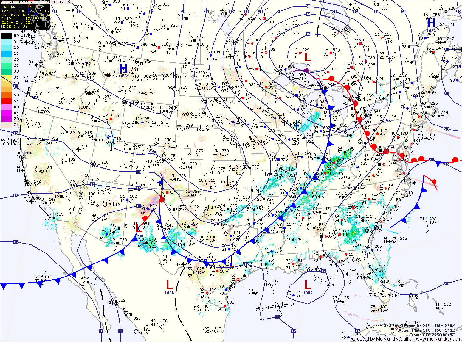
URGENT - WINTER WEATHER MESSAGE NATIONAL WEATHER SERVICE BALTIMORE MD/WASHINGTON DC 1009 AM EST MON DEC 9 2013 WASHINGTON-FREDERICK MD-CARROLL-NORTHERN BALTIMORE-HARFORD-MONTGOMERY-HOWARD-SOUTHERN BALTIMORE-PRINCE GEORGES-ANNE ARUNDEL INCLUDING THE CITIES OF...HAGERSTOWN...FREDERICK... WESTMINSTER...GAITHERSBURG...COLUMBIA...BALTIMORE...ANNAPOLIS... ..WINTER…
Current Surface MapA warm front currently moving through the state has spread ample moisture up the coast resulting in foggy, misty conditions. Highs today will be in the mid 60s.
A cold front is approaching from the west and will move into the area tonight. Expect showers to break out before daybreak tomorrow morning.
Rain chances will increase through the day tomorrow and last thorough tomorrow night. Highs will be in the low to mid 50s tomorrow.
Saturday will be a transition day, as the cold front settles to our south allowing partial clearing. It will be colder with highs in the low 40s.
Cold high pressure will continue to settle into the region late Saturday and Saturday night. This will set the stage for Sunday as an area of low pressure approaches from the southwest.
Current Surface MapLight rain/snow/sleet is moving across the area this morning. The mix will continue into the afternoon before changing to rain in most places.
The exception is far western Maryland, where a Winter Storm Warning is in effect for several inches of snow. Further east, accumulations are not expected. Highs today will top out in the mid to upper 30s.
The cold front will pass through tonight, bringing an end to the precipitation. Tomorrow will feature decreasing clouds and gusty winds. Highs will be in the low 50s.
Current Surface MapLow pressure will move into the area today, bringing rain to the state. Across far western Maryland, temperatures will remain cold enough for freezing rain and a Winter Storm Warning is in effect for Garrett and Allegany counties for significant icing.
Further east, a Winter Weather Advisory is in effect for Washington county where a changeover to rain is expected this afternoon.
Even further east, expect rain to develop later this morning, possibly starting as a brief period of sleet. The rain will be steady through the day and into tonight.
A Flood Watch is in effect for the central part of the state, where around an inch of rainfall is expected.
Current Surface MapFollowing a cold frontal passage yesterday, bitterly cold air has spilled into the region on strong northwest winds. Highs today will struggle into the mid 20s while wind gusts to 30mph will make it feel like it is in the teens.
Tonight will see temperatures drop into the low teens for lows, warming to the mid 20s for highs again tomorrow.
There is a slight chance of light snow, with little to no accumulation tomorrow night as a weak system passes through.
A return to sunshine on Thursday, with highs in the upper 20s to near 30.
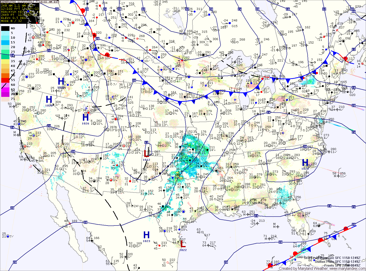
Current Surface MapAs yesterday’s storm pushes northeastward and away from the area, another is taking shape over the Rockies and will move into the area by Saturday morning.
Behind the storm that brought snow, sleet, freezing rain and a lot of plain rain (storm total of 1.31″ here) to the region, skies will gradually clear as northwest winds gust to near 50mph today. A Wind Advisory is in effect until 6pm.
Winds will decrease tonight as weak high pressure builds in tomorrow, providing a calm and tranquil day. Highs will be in the low to mid 40s.
Precipitation will push into the area early Saturday morning. The models are in agreement that the initial precipitation will fall in the form of snow. The models disagree however, on if it will remain snow and how much will fall.