Skip to content
Maryland Weather

Everything you need to know about the weather in Maryland

  • Home
  • Blog Posts
    • Latest Posts
    • Archives
  • Forecasts
    • Local Forecasts
    • Forecast Discussion
  • Station Data
    • Current Data
  • Current Alerts
  • Radar Data
  • Maps & Satellite
    • WPC Maps
    • Satellite
  • Tropical
  • About
  • Subscribe!

flash flood watch

Remnants of Ida to Bring Flooding Rains to Our Area

Remnants of Ida to Bring Flooding Rains to Our Area

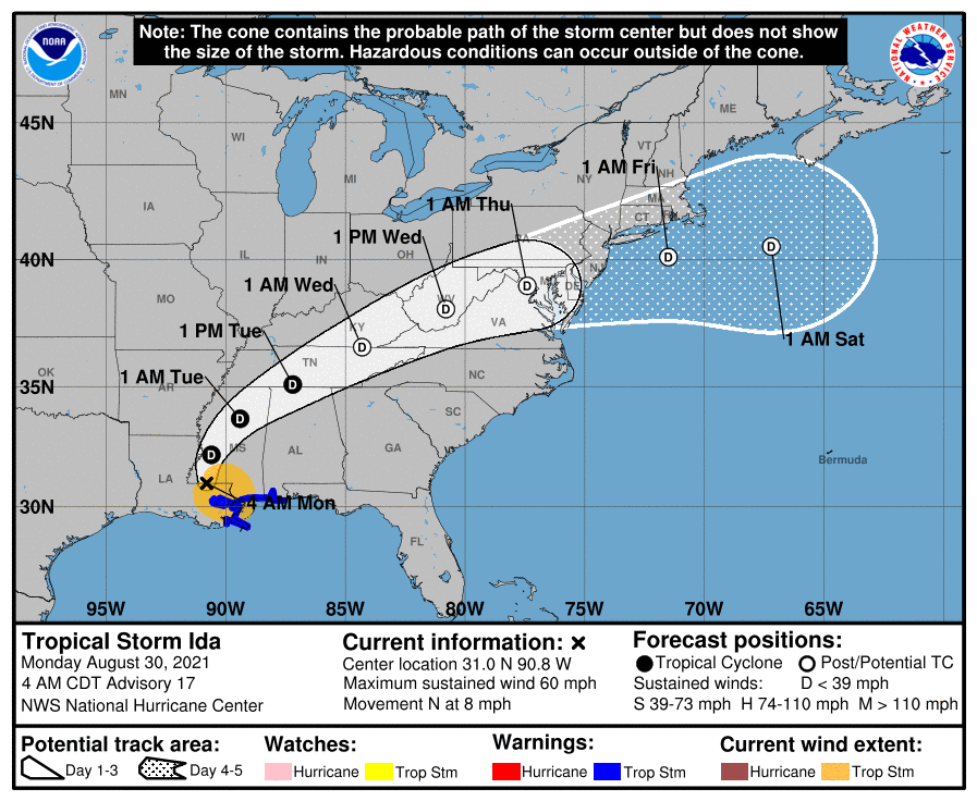
Hurricane Ida made landfall in Louisiana yesterday as a Category 4 storm and has since moved inland and weakened to a tropical storm. The system will continue to weaken as…
Read More
Posted by By Billy DePriest Monday, August 30, 2021Posted inAlert, Forecast

Cold Front and Michael to Bring Periods of Heavy Rain & Wind to the Area

Unlike some of the other major hurricanes that have stalled out after making landfall, Michael hit the Florida panhandle yesterday and has made steady progress northeastward since. The system is…
Read More
Posted by By Billy DePriest Thursday, October 11, 2018Posted inAlert, Forecast

Remnants of Florence Moving Through

As I had mentioned last week, the remnants of Hurricane Florence will pass through our area today and tomorrow bringing showers and thunderstorms. Some of the rainfall could be heavy…
Read More
Posted by By Billy DePriest Monday, September 17, 2018Posted inForecast

Heavy Rain and Thunderstorms Moving In

As expected, areas of heavy rain and embedded thunderstorms are moving into the state from the south this morning. Additional areas of heavy rain and storms will continue to overspread…
Read More
Posted by By Billy DePriest Wednesday, September 28, 2016Posted inAlert, Forecast

Scattered Showers and Storms Today and Tonight; Locally Heavy Rain Possible

Summary: An area of low pressure will move by to our south today through tonight moving off the coast tomorrow. High pressure will return for the weekend. A few waves…
Read More
Posted by By Billy DePriest Thursday, June 16, 2016Posted inAlert, Forecast

Record Warmth with Wind, Rain and T-Storms

Summary: A cold front is approaching from the west. The front will move through tonight, stalling out just to our south tomorrow and returning back northward this weekend. Showers will…
Read More
Posted by By Billy DePriest Thursday, December 24, 2015Posted inForecast

Rain, Heavy at Times Today and Tonight, Tapering to Showers this Weekend

Now that it is all but certain that Hurricane Joaquin will not directly impact our area this weekend, we can focus on the current system that is affecting us. A…
Read More
Posted by By Billy DePriest Friday, October 2, 2015Posted inAlert, Forecast

Showers and Thunderstorms Today; Flash Flooding Possible

A cold front is approaching from the west and will pass through tonight into tomorrow morning. High pressure will build in for the weekend. TODAY: A cold front currently over…
Read More
Posted by By Billy DePriest Thursday, August 20, 2015Posted inForecast

Scattered Showers and Storms Today & Tonight

THE NATIONAL WEATHER SERVICE IN STERLING VIRGINIA HAS ISSUED A FLASH FLOOD WATCH Areas Affected: Anne Arundel; Carroll; Central and Southeast Howard; Central and Southeast Montgomery; Frederick; Northern Baltimore; Northwest…
Read More
Posted by By Billy DePriest Tuesday, July 14, 2015Posted inAlert, Forecast

Mostly Dry Today; Rain Redevelops This Evening, Heavy at Times Through Tomorrow Night

THE NATIONAL WEATHER SERVICE IN STERLING VIRGINIA HAS ISSUED A FLASH FLOOD WATCH FOR PORTIONS OF MARYLAND...INCLUDING THE FOLLOWING AREAS... ANNE ARUNDEL, CARROLL, CENTRAL AND EASTERN ALLEGANY, CENTRAL AND SOUTHEAST…
Read More
Posted by By Billy DePriest Friday, June 26, 2015Posted inAlert, Forecast

Posts pagination

1 2 3 Next page
Current Conditions
Current Air Quality Index
Current Radar
Current Satellite
CPC 8-14 Day Temperature Outlook
CPC 8-14 Day Precipitation Outlook
CPC 1 Month Temperature Outlook
CPC 1 Month Precipitation Outlook
Email Subscription
Get the latest blogs emailed to you!


Instagram

maryland_wx

B.S. Meteorology @valparaiso_university | Skywarn Spotter | Providing weather info including forecasts and alerts for the state of Maryland.

🌬 As cold high pressure continues to settle ove 🌬 As cold high pressure continues to settle over the area, Frost and Freeze alerts have been issued for most of the state.

⚠️ A Freeze Warning is in effect for: Baltimore, Carroll, Frederick, and Harford counties...
* IMPACTS...Frost and freeze conditions will kill crops, other sensitive vegetation and possibly damage unprotected outdoor plumbing.

⚠️ A Frost Advisory is in effect for: Anne Arundel, Caroline, Cecil, Charles, Howard, Kent, Montgomery, Prince Georges, Queen Anne's, and Washington counties...
* IMPACTS...Frost could kill sensitive outdoor vegetation if left uncovered.

See https://www.marylandwx.com/alerts/ for more details.
Rainfall associated with Hurricane Ian has entered Rainfall associated with Hurricane Ian has entered southern portions of the state and will continue to move northward this evening. 

Expect periods of moderate to heavy rainfall tonight into early tomorrow morning before tapering to lighter showers through the day. Steadier rainfall may develop again on Sunday, lasting into Sunday evening as the remnant low spins off the coast.

Rainfall totals of 1-2" are likely by Monday morning.
A strong cold front will bring big changes to our A strong cold front will bring big changes to our weather, just in time for the autumnal equinox! The front will cross today with some showers. Behind it, gusty NW winds will bring in much cooler air. Lows tonight and tomorrow night will fall into the 40s for most areas. Highs tomorrow will only reach the mid 60s. Welcome to fall!
Follow on Instagram
Facebook
Cover for Maryland Weather
10,725
Maryland Weather

Maryland Weather

Weather conditions, forecasts, watches and warnings from the National Weather Service and other weather updates for the state of Maryland.

Operated by Billy DePriest


Affiliations
USA Weather Finder
Copyright 2025 — Maryland Weather. All rights reserved.
Scroll to Top