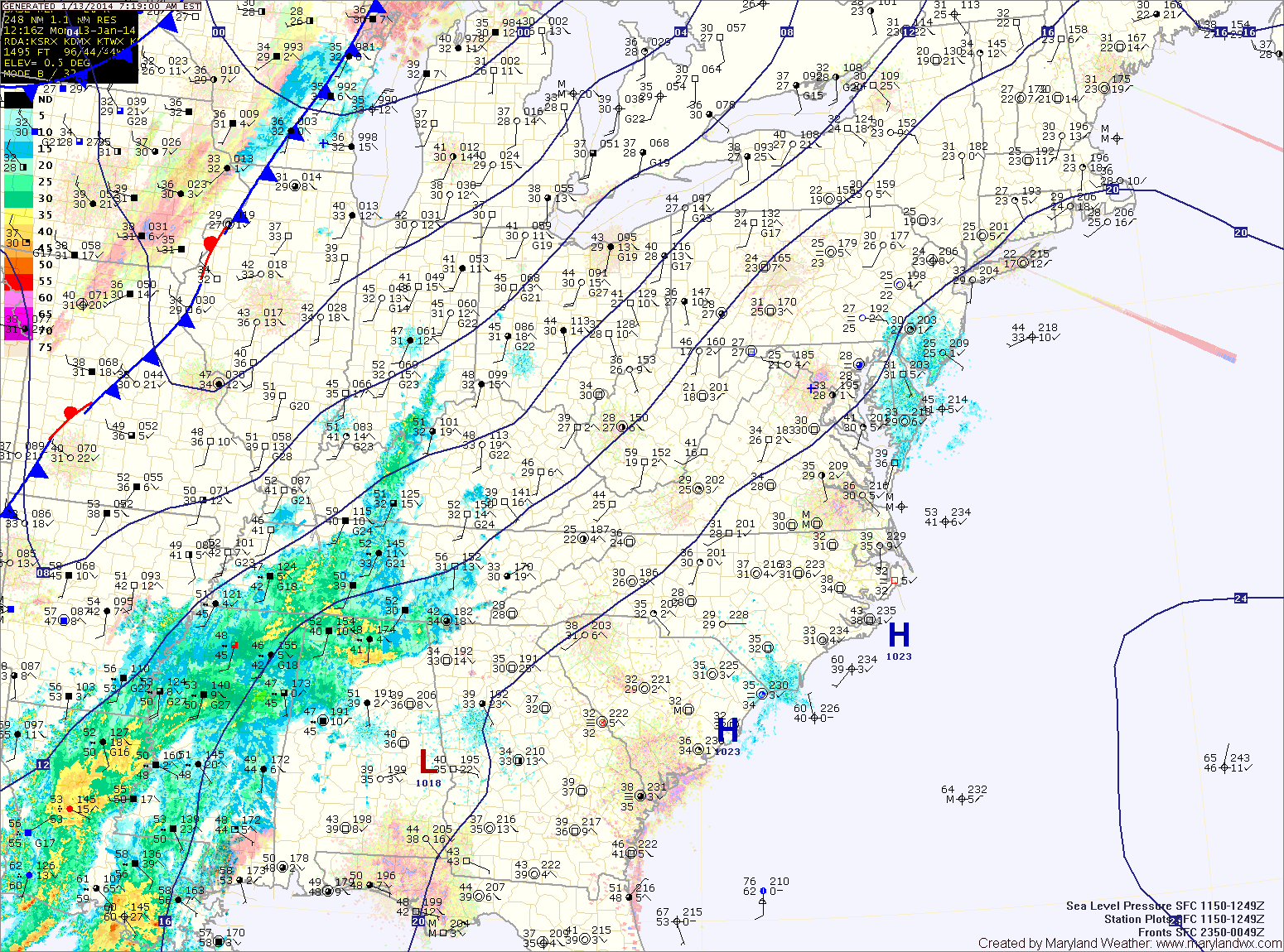
Light wintry mix to rain possible, mainly east; Introducing new forecast zones

Current Surface Map
Current Surface Map
A WINTER WEATHER ADVISORY is in effect for Calvert, Charles, and St. Mary’s counties until noon.


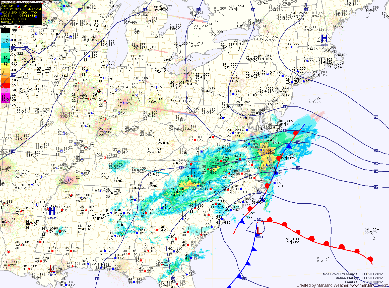
An area of low pressure is moving northeastward off the Carolina coast. The storm will stay well to our south but the northern fringe may spread some light precipitation into the southern and eastern portions of the state.

At the onset, it will be cold enough for any precip that falls to fall in the form of sleet or freezing rain. Temperatures will climb above freezing later this morning, turning any remaining precip over to plain rain. Light showers may persist through the afternoon and into tonight.

Highs today will be around 40 under cloudy skies.

High pressure builds in tomorrow, leading to a pleasant day, with partly sunny skies and highs in the mid 50s.

Partly sunny today and tomorrow; Light snow possible this weekend

Current Surface Map
Current Surface Map
High pressure is building into the region today, resulting in partly sunny skies with highs in the low to mid 30s.

Tomorrow will be similar to today, but a few degrees warmer with highs in the mid to upper 30s.

This weekend, we will be impacted by two separate areas of low pressure. At one point, it looked as those these two pieces of energy may phase and produce a significant storm along the east coast. Now, it appears the southern low will scoot by to our south and the northern low will move by without phasing. This will result in a chance of light snow Saturday into Sunday but nothing significant. Highs both days will be in the mid 30s.

Partly Sunny Today; Cold Front Crosses Tomorrow

Current Surface Map
Current Surface Map
Clouds will thicken today as a cold front approaches from the west. The front will spread showers into the area tonight and tomorrow. Highs today will be in the low to mid 50s.

Tomorrow will have highs in the low 50s with scattered showers into the evening.

Another weak front will move through on Wednesday, bringing a slight chance of rain or snow showers as it does. Highs will be in the low 40s.

Rain Today; Chance of Snow Showers Tomorrow

Current Surface Map
Current Surface Map
A conveyor belt of moisture originating in the tropical Pacific continues to slide up the coast ahead of a cold front. Expect periods of rain through late afternoon today. Temperatures will continue to drop through the day, falling into the 40s by evening.

The front clears the area tonight, bringing an end to the rain and allowing colder air to filter in. Meanwhile, a potent upper level system will swing through tomorrow bringing the possibility of snow squalls during the afternoon, mainly across the mountains. Brief isolated snow showers could make it into Central Maryland, with little to no accumulation expected. Temperatures will be above freezing (mid to upper 30s) so any accumulation will quickly melt.

Becoming Sunny Today; Dry Through End of the Week

Current Surface Map
Current Surface Map
As high pressure continues to build in, expect clearing skies and cooler temperatures. It will also turn breezy this afternoon. Highs today will be in the upper 40s to around 50.

The high will move overhead tomorrow, diminishing winds. It will be mostly sunny with highs in the upper 40s.

As the high moves off the coast on Thursday, southerly flow will bring in slightly warmer air and a few more clouds. Highs on Thursday will be in the low to mid 50s under partly sunny skies.

Friday will be a few degrees warmer, with highs in the mid to upper 50s under partly sunny skies.

Cold and Breezy Today; Dry into the Weekend

Current Surface Map
Current Surface Map
As cold high pressure continues to push into the area, expect mostly sunny skies today. It will be breezy and cold, with highs in the low to mid 40s.

Another cold night is on tap tonight, with lows dipping into the mid 20s once again.

Temperatures begin to moderate tomorrow under continued sunny skies. Highs will be in the mid 50s.

As the high slides off the coast, a more southerly flow will develop. As a result, clouds will increase a bit on Friday but temperatures will continue to warm with highs expected to push into the upper 50s.

Mostly Sunny and Cool Today

Current Surface Map
Current Surface Map
With cold high pressure to our north, today will likely be the coldest day since early April. High temperatures will likely remain below 50 degrees, topping out in the upper 40s in most areas.

Tomorrow and Wednesday will feature a mix of clouds and sun with progressively warmer temperatures. Expect highs in the mid 50s tomorrow, warming to the mid 60s on Wednesday.

A cold front will approach and move through on Thursday. Showers are likely with this frontal passage starting late Wednesday night and lasting through the day Thursday. Highs will be near 70 degrees.

Mostly Sunny and Dry through Midweek

Current Surface Map
Current Surface Map
A weak cold front will move through this afternoon, doing nothing more than shifting the winds to the northwest. Expect mostly sunny skies and highs in the low 60s.

Tomorrow will be mostly sunny with highs in the upper 50s.

Wednesday will see an increase in clouds and perhaps a few afternoon showers as a disturbance moves by. Highs will be in the low to mid 60s.

Thursday will feature more clouds than sun as a cold front approaches from the west. Highs will approach 70 degrees as southerly flow develops ahead of the front.

Clouds and Sun Today; Nice Weekend on Tap

Current Surface Map
Current Surface Map
Today will be very similar to yesterday. Breezy and cool under variable clouds. Highs will be in the low 50s.

Another night of low temperatures near or below freezing for most areas away from the water tonight.

After a chilly start, tomorrow will be sunny with highs in the mid to upper 50s.

A weak cold front will move through tomorrow night bringing scattered clouds with it as it does. The front will clear out on Sunday morning and afternoon highs will reach the mid to upper 50s under mostly sunny skies.