Becoming Sunny Today; Continued Cool

Current Surface Map
Current Surface Map
Expect clearing skies and continued colder than normal temperatures. Highs will top out in the upper 40s.

High pressure will slide off the coast tomorrow allowing high clouds to increase again and temperatures to rise a bit. Highs will be in the low 50s under partly sunny skies.

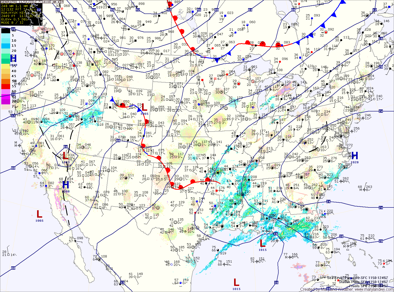
A cold front will approach on Friday, increasing southerly flow and bringing in even milder air. Highs on Friday will be in the upper 50s under partly sunny skies.

The front will move closer Friday night, spreading showers into the area. Showers will continue to affect the state Saturday into Saturday evening before the front moves through. Highs on Saturday will be in the mid 50s.

Partly Sunny Today; Showers Likely Tonight into Tomorrow Morning

Current Surface Map
Current Surface Map
High pressure will continue to slide off the Carolina coast today and clouds will begin to increase as an area showers over the southeast move toward the area. Highs today will be in the mid to upper 50s.

The area of showers will move through tonight and early tomorrow morning. Tomorrow will end up partly sunny, with highs in the mid 50s.

Clouds will increase again on Sunday and scattered showers may develop during the afternoon. Highs will be in the mid 60s.

A cold front will spread showers through the state Sunday night and Monday before pushing off the coast Monday afternoon. Highs will top out in the mid 60s before falling behind the front.

Sunny Today; Warming Trend into the Weekend

Current Surface Map
Current Surface Map
High pressure to our south will continue to provide clear skies today as temperatures rebound a bit and warm into the mid 50s.

Tomorrow will be mostly sunny and even warmer, with highs approaching 60 degrees.

Clouds will increase tomorrow night as a piece of upper level energy moves by to our south and east. This system will bring a slight chance of a sprinkle early Saturday morning before moving away. Otherwise, Saturday will be partly sunny with highs around 60.

Scattered showers will develop Sunday ahead of the next cold front that will move through on Monday. Sunday’s highs will be in the low to mid 60s.

Cold and Breezy Today; Dry into the Weekend

Current Surface Map
Current Surface Map
As cold high pressure continues to push into the area, expect mostly sunny skies today. It will be breezy and cold, with highs in the low to mid 40s.

Another cold night is on tap tonight, with lows dipping into the mid 20s once again.

Temperatures begin to moderate tomorrow under continued sunny skies. Highs will be in the mid 50s.

As the high slides off the coast, a more southerly flow will develop. As a result, clouds will increase a bit on Friday but temperatures will continue to warm with highs expected to push into the upper 50s.

Arctic Front Moving Through

Current Surface Map
Current Surface Map
An arctic cold front is moving through the region, bringing much colder air, gusty winds and scattered snow showers as it does. Today’s high temperature was 53 degrees at midnight.

Temperatures will continue to fall into the 30s this morning before rebounding a little this afternoon, topping out around 40 degrees. East of the mountains, no snow accumulation is expected.

Tomorrow will be sunny but breezy and cold, with highs in the low to mid 40s.

With high pressure overhead, Thursday will be sunny with light winds and highs in the upper 40s.

Mostly Sunny Today; Strong Cold Front Moves Through Tonight

Current Surface Map
Current Surface Map
Today will be mostly sunny with a high in the mid 50s.

A strong cold front will move into the region tonight and through by tomorrow morning. The front will bring scattered showers, possibly ending as snow showers tomorrow morning. The front will also bring very cold air to the region on gusty northwest winds. Highs tomorrow will be around 40 degrees with wind gusts to near 25 mph.

Overnight lows Tuesday night will dip into the mid to upper 20s.

Wednesday will be sunny but blustery and cold, with highs in the low 40s.

Clouds and Sun Today; Nice Weekend on Tap

Current Surface Map
Current Surface Map
Today will be very similar to yesterday. Breezy and cool under variable clouds. Highs will be in the low 50s.

Another night of low temperatures near or below freezing for most areas away from the water tonight.

After a chilly start, tomorrow will be sunny with highs in the mid to upper 50s.

A weak cold front will move through tomorrow night bringing scattered clouds with it as it does. The front will clear out on Sunday morning and afternoon highs will reach the mid to upper 50s under mostly sunny skies.

Partly Sunny, Continued Windy

Current Surface Map
Current Surface Map
As we remain under the influence of high pressure to our west and low pressure to our east, another day of partial sunshine, a chance of a sprinkle and gusty winds is on tap. Highs today will be in the low 50s.

A slight improvement tomorrow, with more sunshine and decreasing winds. Highs will be in the mid 50s.

Saturday will feature even more sunshine and warmer temps. Expect highs near 60.

Sunday will start off dry, with increasing clouds as a cold front approaches from the west.

Quiet to Begin the Weekend; Rain/Snow Likely Late Sunday

Current Surface Map
Current Surface Map
Expect mostly sunny skies and windy conditions today. Highs will be in the mid 40s.

Tomorrow will be similar to today, although not as windy. Clouds will begin to increase during the late afternoon in advance of a storm system that will begin to affect the area on Sunday. Highs will be in the low 50s.

An area of low pressure is expected to move northward to our west before dying out while another area forms off the coast. The exact placement, strength and timing of this transfer will determine precipitation types across the state.

Rain Develops Today, Changes to Snow Tonight

Current Surface Map
Current Surface Map
Low pressure moving across the southeast will slide off the Virginia coast tonight. As it does, light rain will develop across the state this afternoon. Highs today will be around 40 degrees.

As temperatures drop tonight, the rain will mix with and then change to snow. An inch or two of snow is possible across northern Maryland, up to an inch across central Maryland with little to no accumulation across southern Maryland.

Skies will clear tomorrow, with a mostly sunny afternoon. Highs will be in the mid to upper 40s.

Friday will be dry, with clouds increasing through the day as a cold front approaches. Highs will be in the upper 40s to around 50.