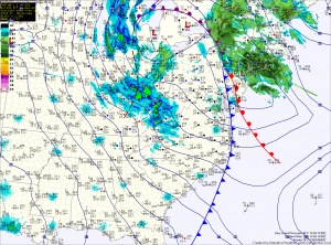
Snow Ending; Windy and Cold Today

Current Surface Map
Current Surface Map
Light snow will continue to taper off across the area this morning. As it does, expect winds to increase and gust to near 40mph again this afternoon. Highs today will be in the low to mid 30s.

Tomorrow will be partly sunny, as another clipper system approaches. Highs will be in the mid 30s.

Expect another round of light snow to develop tomorrow night as the next system moves in. The snow showers will continue Sunday.

A dusting to an inch of snow may accumulate during the overnight while Sunday’s snow will be falling with temperatures above freezing, which will limit additional accumulation. Winds will increase again Sunday evening into Sunday night.

Clearing Today; More Light Snow Tomorrow

Current Surface Map
Current Surface Map
As one over-performing storm departs, another will bring more snow to the area tomorrow. In between, expect a sunny but cold and windy day today. Highs will top out in the mid to upper 20s.

Last night’s clipper brought a dusting to northern parts of the state, while nearly 5 inches of snow fell across southern St. Mary’s county. Totals across central Maryland of 1-2″ were common.

The next system will have a bit more moisture with it, but will be a fast mover. Expect snow to develop during the afternoon and last into tomorrow night. Snowfall totals of 1-3″ are expected at this time, impacting the evening rush hour.

Behind that system, a cold and dry weekend is on tap. Highs on Saturday will push to near freezing, pushing into the mid 30s on Sunday.

Cold Again Today; Light Snow Tonight, again Friday

Current Surface Map
Current Surface Map
After a Tuesday in which we didn’t break the mid 20s, a cold Wednesday will follow. Expect similar temperatures to yesterday, with less wind. Highs today will be in the mid 20s.

A weak Alberta Clipper will move through tonight, bringing a chance of light snow to the area. Overnight accumulations of a dusting to possibly an inch in spots is possible.

The clipper moves out tomorrow, giving way to mostly sunny skies with highs in the upper 20s to around 30.

Clouds increase again on Friday ahead of the next storm system that looks to bring light snow to the area Friday afternoon into Friday night. Highs Friday wil be in the upper 20s.

Very Cold and Windy; Chance of Wintry Precip on Friday

Current Surface Map
Current Surface Map
Following a cold frontal passage yesterday, bitterly cold air has spilled into the region on strong northwest winds. Highs today will struggle into the mid 20s while wind gusts to 30mph will make it feel like it is in the teens.

Tonight will see temperatures drop into the low teens for lows, warming to the mid 20s for highs again tomorrow.

There is a slight chance of light snow, with little to no accumulation tomorrow night as a weak system passes through.

A return to sunshine on Thursday, with highs in the upper 20s to near 30.

Light Snow Expected Tomorrow

Current Surface Map
Current Surface Map

A fast moving area of low pressure will bring light snow to the area tomorrow.

The low is currently over eastern Texas and it will quickly move by to our south during the day tomorrow before it strengthens and moves towards New England.

Expect light snow to develop during the pre-dawn hours tomorrow morning, mixing with or changing to rain in southern Maryland and the lower Eastern Shore.

The rain/snow line will approach the I-95 corridor by tomorrow afternoon and may push into the Baltimore/Washington metro areas.

Windy and Cold Weekend

Current Surface Map
Current Surface Map
Today is the first day of winter and it will certainly feel like it!

The cold front that brought heavy rain and wind to the area last night has pushed off the coast and colder air is beginning to filter into the region.

Winds will increase through the day today as the storm intensifies to our north. Highs today were reached at 2:40 this morning and will continue to drop through the day, into the 30s this evening.

Winds will gust to around 30mph this afternoon, making it feel even colder. There may be a sprinkle or flurry this afternoon as well.

In far western Maryland, snow will continue to fall and combine with the strong winds to produce blizzard conditions at times through tomorrow.

Sandy Taking Aim on the Delmarva

Current Surface Map
High pressure to our northeast is keeping the region in easterly flow. This has resulted in low clouds and areas of drizzle. A few breaks in the clouds are anticipated this afternoon allowing highs today to push into the low 70s.

Hurricane Sandy continues to be the focus of attention as we head into the weekend. Consensus is building that the storm will combine with the cold front to our west to have a significant impact on our area.

*The Setup*

The high pressure to our northeast will block and even steer Sandy towards the coast early next week. Meanwhile, Sandy continues to slow and grow in size. This is important to remember when looking at the path outlined by the National Hurricane Center. Sandy will likely be a very large in size and will bring significant impacts to a very large portion of the east coast regardless of the exact path.

Sandy is currently over the northern Bahamas and moving northwestward. Maximum sustained winds are now 80mph. This general motion and strength are expected to continue today before Sandy makes a gradual turn back towards the northeast tomorrow. This is due to the front to our west that will eventually absorb the system.

Current Forecast Track
As mentioned above, the movement to the northeast will be blocked by the high pressure off the New England coast. The high will steer Sandy back to the west where it will make landfall.