
A Winter Storm Watch has been issued for:
Allegany, Anne Arundel, Baltimore, Baltimore City, Calvert, Caroline, Cecil, Charles, Frederick, Garrett, Harford, Howard, Kent, Montgomery, Prince George’s, Queen Anne’s, St. Mary’s, Talbot and Washington counties
A cold front will slide through the area tomorrow evening, setting the stage for an overrunning winter storm Wednesday night into Thursday that may end up being the biggest storm of the year for many parts of the state.
As the front slips south of the state, an area of low pressure will ride along it and spread precipitation into the state. The precipitation will start as rain tomorrow and last into tomorrow night. As the colder air works in and another wave of precipitation moves in, the rain will change to snow from northwest to southeast during the overnight. The snow will be moderate to heavy at times through Thursday morning and then begin tapering off during the afternoon hours before ending in the evening.
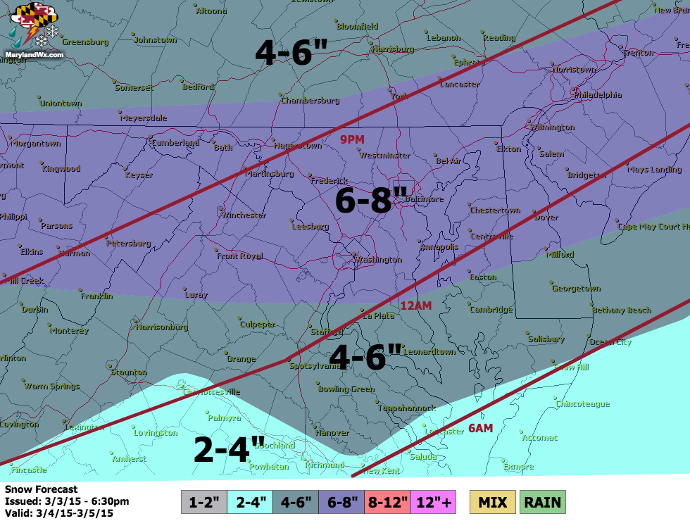
Here is my preliminary snow forecast for the event with approximate changeover times in red. These totals account for possible lost accumulation due to the wet ground prior to the transition.
The storm will pull away Thursday evening and very cold air will move in behind it. Lows will fall into the low 10s to upper single digits Thursday night and Friday morning and will likely only reach the mid 20s Friday afternoon.
I will refine this forecast tomorrow to account for the latest model information, but be prepared for a high-impact snow event late Wednesday night and Thursday.