
------
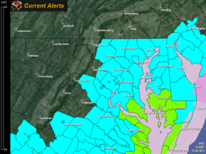
*A FREEZE WATCH is in effect for tonight for: Baltimore, Carroll, Frederick, Harford, Howard, and Montgomery counties*
------
------
*A FREEZE WATCH is in effect for tomorrow night for: Anne Arundel, Baltimore, Calvert, Caroline, Carroll, Cecil, Charles, Dorchester, Frederick, Harford, Howard, Kent, Montgomery, Prince George's, Queen Anne's, Somerset, St. Mary's, Talbot, Wicomico, and Worcester counties*
------
A cold front will push through the state tonight, bringing much colder air on gusty north winds. Temperatures will likely drop below freezing tonight in areas north and west of I-95, while the brunt of the cold air moves in tomorrow and tomorrow night. Highs tomorrow will be in the upper 30s to low 40s in most areas as north winds gust over 30 mph, making it feel even colder.
Temperatures will plummet tomorrow night, falling below freezing after sunset and will bottom out in the upper teens to low 20s by early Saturday morning. Any sensitive vegetation will be damaged or killed with this freeze.
Winds should die down on Saturday but it will remain cold, with highs once again in the upper 30s to low 40s under sunny skies.
Sunday will be a bit warmer, with highs reaching the mid to upper 40s with increasing clouds as another system moves towards the area.
Temperatures will continue to moderate early next week with highs back into the 50s Monday through Wednesday.
Want the latest blog posts emailed to you?