
High pressure remains off of the coast, pumping warm and humid air into the region. A weak front will move into the area today followed by another weak front tomorrow and a stronger front on Sunday.
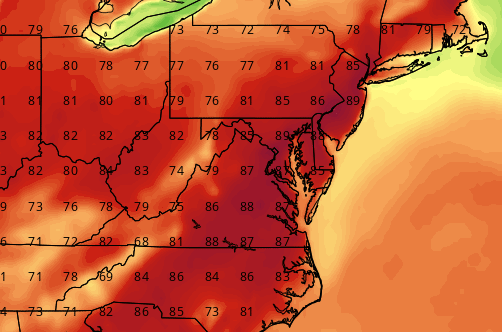
FRIDAY: Another weak front will move in from the northwest, weakening over our area and interacting with the warm humid air in place. This will result in more scattered showers and thunderstorms. Highs will be in the low to mid 80s.
SATURDAY: Ahead of an approaching cold front, temperatures will warm into the mid to upper 80s with a mix of clouds and sun. An afternoon shower or thunderstorm will again be possible.
SUNDAY: A stronger cold front will move into the area from the northwest making showers and thunderstorms likely. Highs will be in the low 80s.
OUTLOOK: Showers will be likely the first part of the week as the front slowly sags south of the area. Expect highs in the low 70s Monday and Tuesday.
Stay up to date with storm information on your favorite social media site!
Follow me on Twitter, Facebook and Google+!