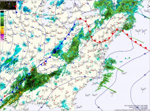
These two features will allow showers to develop this afternoon and into tonight. Highs today will push into the mid 60s ahead of the front.
The front clears the area late tonight, bringing an end to the showers.
Colder and drier air will flow into the area tomorrow on gusty northwest winds. Temperatures will struggle climb and may even drop through the day. Highs will likely be reached tomorrow morning, topping out around 50 degrees.
High pressure builds in Wednesday, calming winds and setting up a stretch of dry and seasonal weather. Highs Wednesday will top out in the mid to upper 40s.
Expect mostly sunny skies for the remainder of the work week and into the weekend with highs remaining around 50 degrees.
The next cold front looks to arrive Sunday, bringing another chance of showers.
Yesterday’s Weather Station Stats:
High Temp: 50.6°
Low Temp: 45.7°
Rain: 0.23″
