Skip to content
Maryland Weather

Everything you need to know about the weather in Maryland

  • Home
  • Blog Posts
    • Latest Posts
    • Archives
  • Forecasts
    • Local Forecasts
    • Forecast Discussion
  • Station Data
    • Current Data
  • Current Alerts
  • Radar Data
  • Maps & Satellite
    • WPC Maps
    • Satellite
  • Tropical
  • About
  • Subscribe!

winter storm watch

Wild Weather Saturday with Snow, Rain, and Wind Expected

Wild Weather Saturday with Snow, Rain, and Wind Expected

A potent cold front and developing low pressure will make for an active weather day across the state on Saturday. Expect rain, moderate to possibly heavy at times to move…
Read More
Posted by By Billy DePriest Thursday, March 10, 2022Posted inAlert, Forecast

Winter Storm Watches Issued – Heavy Snow and Ice Possible

The National Weather Service has issued Winter Storm Watches for all areas west of the bay ahead of the next storm system that will bring wintry weather to our area…
Read More
Posted by By Billy DePriest Tuesday, February 16, 2021Posted inAlert, Forecast

Tracking the Ice Threat for Late Tomorrow-Sunday

With surface temperatures expected to be in the upper 20s to low 30s, another system approaching from the southwest will bring the threat of more wintry weather late tomorrow into…
Read More
Posted by By Billy DePriest Friday, February 12, 2021Posted inAlert, Forecast

Forecast Update – 12/15/20

A trend in the models that started yesterday has continued today, with a storm track further west, and as a result, warmer air pushing further west than what was modeled…
Read More
Posted by By Billy DePriest Tuesday, December 15, 2020Posted inAlert, Forecast

First Call Forecast – 12/16-12/17

Here is my first call for the storm that will affect our area Wednesday into Thursday morning. Winter Storm Watches have been issued for areas west of I-95, where confidence…
Read More
Posted by By Billy DePriest Monday, December 14, 2020Posted inAlert, Forecast

3rd Wintry Event of the Weekend to Impact our area Tomorrow

Summary: An area of low pressure developing over the southeast will move northeastward tomorrow, passing by to our southeast tomorrow night. The third of a series of storm systems is…
Read More
Posted by By Billy DePriest Saturday, March 2, 2019Posted inAlert, Forecast

Winter Storm Watch Issued: Snow, Sleet, Freezing Rain on the Way

Summary: An area of low pressure will move into the region tomorrow night. High pressure will funnel cold air into our area, setting the stage for a high impact winter…
Read More
Posted by By Billy DePriest Monday, February 18, 2019Posted inAlert, Forecast

Wintry Mix Ongoing – More Mix to Rain Tonight

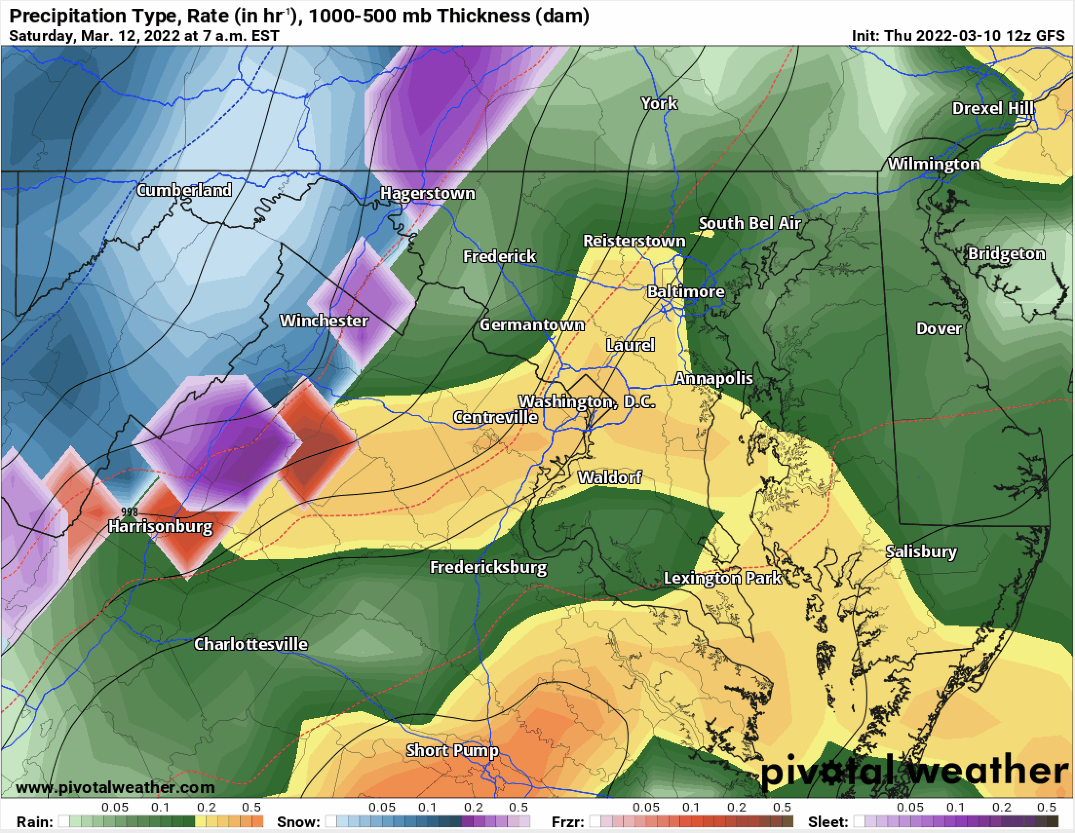
Summary: A weak area of low pressure continues to spread a wintry mix across the area this morning. Another, stronger system will bring more precipitation tonight and tomorrow. A wintry…
Read More
Posted by By Billy DePriest Monday, February 11, 2019Posted inAlert, Forecast

A Wintry Mix to Greet the First Day of Spring – Update #2

This is an update to: - A Wintry Mix to Greet the First Day of Spring - A Wintry Mix to Greet the First Day of Spring – Update ------…
Read More
Posted by By Billy DePriest Tuesday, March 20, 2018Posted inAlert, Forecast, Update

A Wintry Mix to Greet the First Day of Spring – Update

This is an update to the post: A Wintry Mix to Greet the First Day of Spring Current Alerts: A *WINTER STORM WARNING* has been issued for Garrett county. ---…
Read More
Posted by By Billy DePriest Monday, March 19, 2018Posted inAlert, Forecast

Posts pagination

1 2 3 … 5 Next page
Current Conditions
Current Air Quality Index
Current Radar
Current Satellite
CPC 8-14 Day Temperature Outlook
CPC 8-14 Day Precipitation Outlook
CPC 1 Month Temperature Outlook
CPC 1 Month Precipitation Outlook
Email Subscription
Get the latest blogs emailed to you!


Instagram

maryland_wx

B.S. Meteorology @valparaiso_university | Skywarn Spotter | Providing weather info including forecasts and alerts for the state of Maryland.

🌬 As cold high pressure continues to settle ove 🌬 As cold high pressure continues to settle over the area, Frost and Freeze alerts have been issued for most of the state.

⚠️ A Freeze Warning is in effect for: Baltimore, Carroll, Frederick, and Harford counties...
* IMPACTS...Frost and freeze conditions will kill crops, other sensitive vegetation and possibly damage unprotected outdoor plumbing.

⚠️ A Frost Advisory is in effect for: Anne Arundel, Caroline, Cecil, Charles, Howard, Kent, Montgomery, Prince Georges, Queen Anne's, and Washington counties...
* IMPACTS...Frost could kill sensitive outdoor vegetation if left uncovered.

See https://www.marylandwx.com/alerts/ for more details.
Rainfall associated with Hurricane Ian has entered Rainfall associated with Hurricane Ian has entered southern portions of the state and will continue to move northward this evening. 

Expect periods of moderate to heavy rainfall tonight into early tomorrow morning before tapering to lighter showers through the day. Steadier rainfall may develop again on Sunday, lasting into Sunday evening as the remnant low spins off the coast.

Rainfall totals of 1-2" are likely by Monday morning.
A strong cold front will bring big changes to our A strong cold front will bring big changes to our weather, just in time for the autumnal equinox! The front will cross today with some showers. Behind it, gusty NW winds will bring in much cooler air. Lows tonight and tomorrow night will fall into the 40s for most areas. Highs tomorrow will only reach the mid 60s. Welcome to fall!
Follow on Instagram
Facebook
Cover for Maryland Weather
10,725
Maryland Weather

Maryland Weather

Weather conditions, forecasts, watches and warnings from the National Weather Service and other weather updates for the state of Maryland.

Operated by Billy DePriest


Affiliations
USA Weather Finder
Copyright 2025 — Maryland Weather. All rights reserved.
Scroll to Top