Remnants of Ida to Bring Flooding Rains to Our Area
Hurricane Ida made landfall in Louisiana yesterday as a Category 4 storm and has since moved inland and weakened to a tropical storm. The system will continue to weaken as…

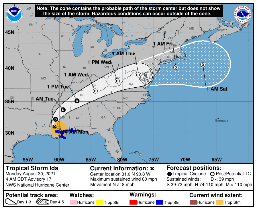
Over an inch of rain has fallen across most of the state and another 2-3 inches with isolated spots over 4 are possible today and tonight. Consequently, a Flash Flood Watch is in effect for most of the state, east of the mountains through tonight.
Rain from Andrea will taper off around midnight tonight as the storm system races off to the northeast. Behind the system, warm, moist, tropical air will be left in place. This will set the stage for a muggy Saturday with scattered afternoon showers and thunderstorms. Highs will be around 80 degrees.

Hurricane Sandy continues to be the focus of attention as we head into the weekend. Consensus is building that the storm will combine with the cold front to our west to have a significant impact on our area.
*The Setup*
The high pressure to our northeast will block and even steer Sandy towards the coast early next week. Meanwhile, Sandy continues to slow and grow in size. This is important to remember when looking at the path outlined by the National Hurricane Center. Sandy will likely be a very large in size and will bring significant impacts to a very large portion of the east coast regardless of the exact path.
Sandy is currently over the northern Bahamas and moving northwestward. Maximum sustained winds are now 80mph. This general motion and strength are expected to continue today before Sandy makes a gradual turn back towards the northeast tomorrow. This is due to the front to our west that will eventually absorb the system. 

High pressure off the New England coast will set up an easterly flow tomorrow. This will bring in more clouds and a chance of drizzle as we move towards tomorrow night. Highs tomorrow will be held down by the increase in clouds, topping out in the low 70s. Areas west of I-95 may push into the mid to upper 70s under more sunshine.
Friday looks like to be similar to Thursday. Partly sunny skies and highs in the low to mid 70s.

As the area of high pressure moves eastward and off the coast, the heat and humidity will begin to build. We will have one more day in the 80s tomorrow before approaching the low 90s on Thursday and pushing into the mid to upper 90s on Friday and Saturday.

The front should clear the state tonight, bringing an end to the rain and allowing high pressure to move in with cooler air. Tomorrow will be pleasant, with highs around 80 degrees under sunny skies. Wednesday will be a few degrees warmer, but still extremely nice for late June.

The other notable weather feature is the first Tropical Storm of the season. Tropical Storm Alberto formed over the weekend off the South Carolina coast. The storm currently has sustained winds of 40mph and will move away from the coast as it weakens and moves out to sea and will not affect the area.