Skip to content
Maryland Weather

Everything you need to know about the weather in Maryland

  • Home
  • Blog Posts
    • Latest Posts
    • Archives
  • Forecasts
    • Local Forecasts
    • Forecast Discussion
  • Station Data
    • Current Data
  • Current Alerts
  • Radar Data
  • Maps & Satellite
    • WPC Maps
    • Satellite
  • Tropical
  • About
  • Subscribe!

rain

Cool and Cloudy; Widespread Rainfall Thursday into Friday

Cool and Cloudy; Widespread Rainfall Thursday into Friday

Weak low pressure will continue to push through our area today, keeping us cool and cloudy, with an occasional sprinkle possible. We will warm a little tomorrow, with highs in…
Read More
Posted by By Billy DePriest Tuesday, March 16, 2021Posted inForecast, Outlook
A Return To Normalcy

A Return To Normalcy

After a very mild and dry week, culminating with record highs yesterday, a cold front is currently moving through the state, bringing clouds, a few sprinkles, and by this evening,…
Read More
Posted by By Billy DePriest Friday, March 12, 2021Posted inForecast, Outlook
Welcome to (Meteorological) Spring!

Welcome to (Meteorological) Spring!

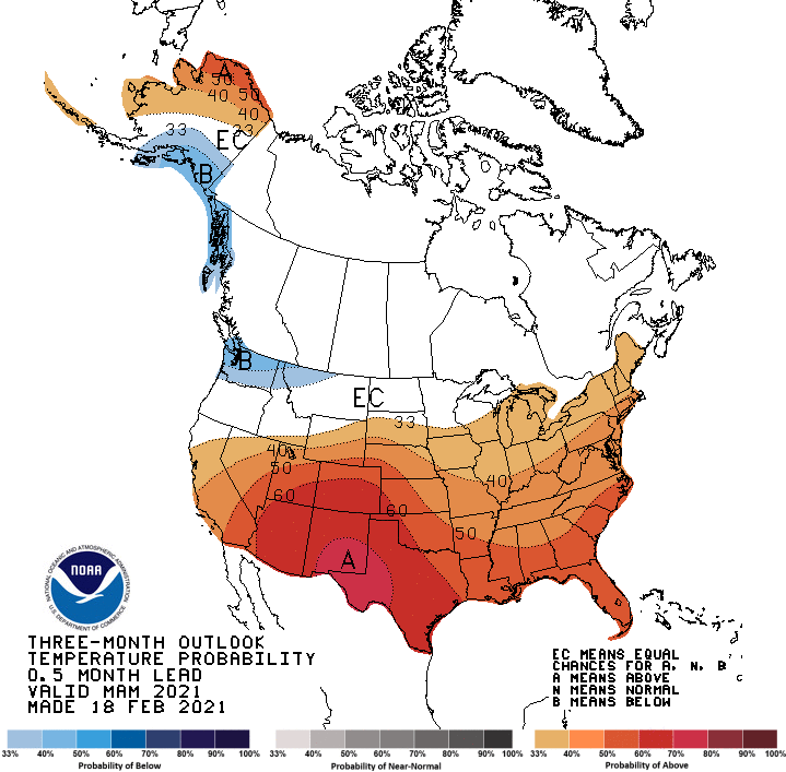
Today is March 1st, and it is the first day of Meteorological Spring! The current 3-month outlooks from the Climate Prediction Center show temperatures likely to be warmer than normal,…
Read More
Posted by By Billy DePriest Monday, March 1, 2021Posted inAlert, Forecast, Outlook
Mild but Wet Weekend on Tap

Mild but Wet Weekend on Tap

Today will see increasing clouds, and highs in the mid to upper 40s. A storm system will approach from the southwest, bringing rain, and a wintry mix in the higher…
Read More
Posted by By Billy DePriest Friday, February 26, 2021Posted inAlert, Forecast
Spring-Like Warmth Today; Cooler to end the Week

Spring-Like Warmth Today; Cooler to end the Week

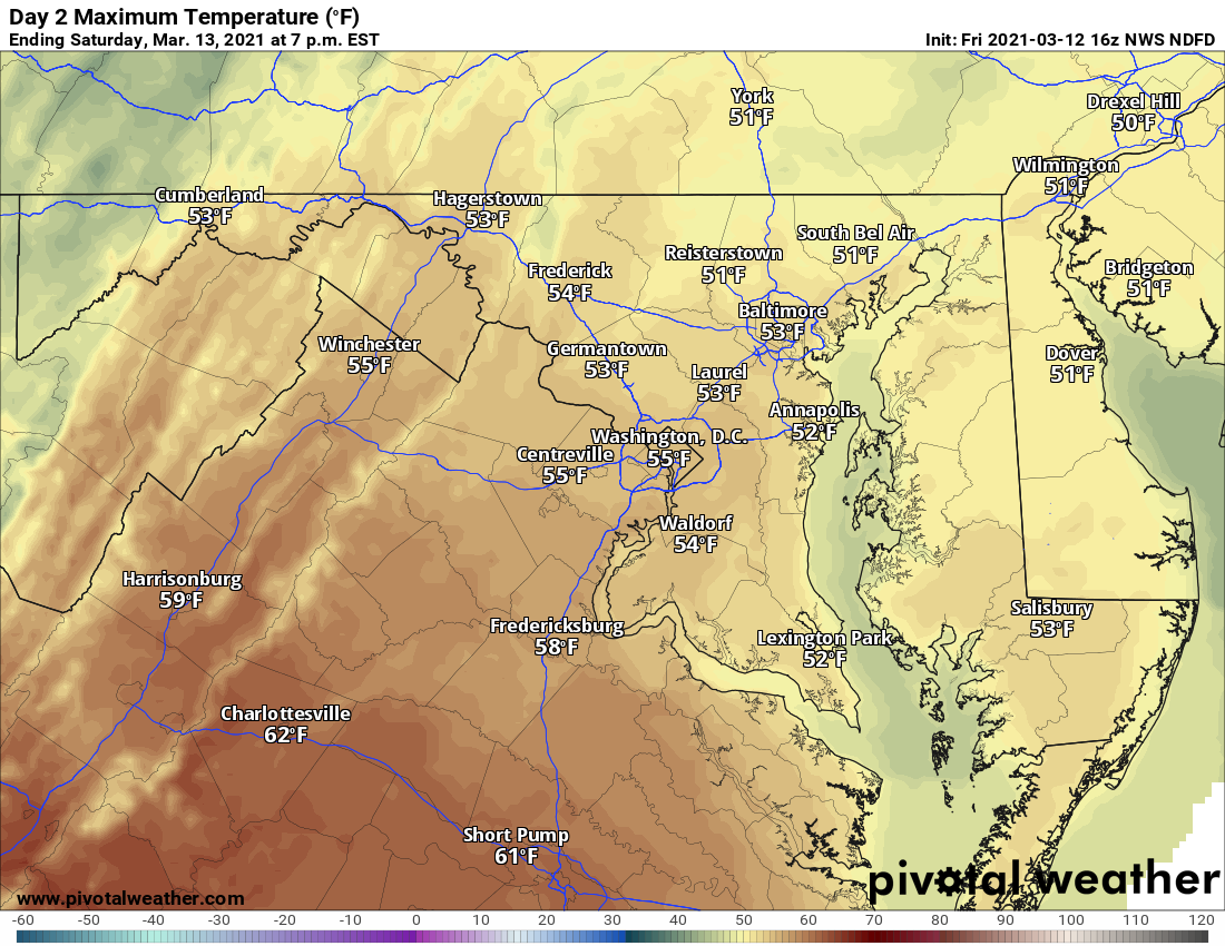
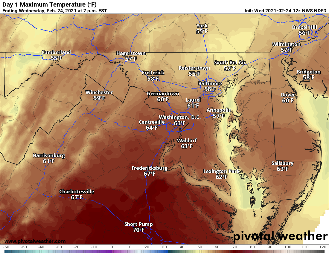
As advertised, today will see highs approach, and perhaps exceed 60 degrees in many spots under mostly sunny skies. It will be breezy, but not as windy as yesterday as…
Read More
Posted by By Billy DePriest Wednesday, February 24, 2021Posted inForecast

Period of Snow Likely Tomorrow Morning

A quick moving area of low pressure is poised to move by to our north during the day tomorrow, bringing another round of precipitation to our state. We will be…
Read More
Posted by By Billy DePriest Sunday, February 21, 2021Posted inForecast

Winter Storm to Bring Snow, Sleet, Freezing Rain Tomorrow

As cold air settles in over the eastern US, a potent area of low pressure will approach from the south. The system will move into our area during the morning…
Read More
Posted by By Billy DePriest Wednesday, February 17, 2021Posted inAlert, Forecast

Another Active, Wintry Week Ahead

With cold high pressure remaining over eastern Canada, and several more storm systems expected to develop, we are facing another week of active wintry weather. Today: Ongoing intermittent light freezing…
Read More
Posted by By Billy DePriest Monday, February 15, 2021Posted inForecast, Outlook

No Updates to First Forecast – A Quick, Moderate Snowfall Likely Tomorrow

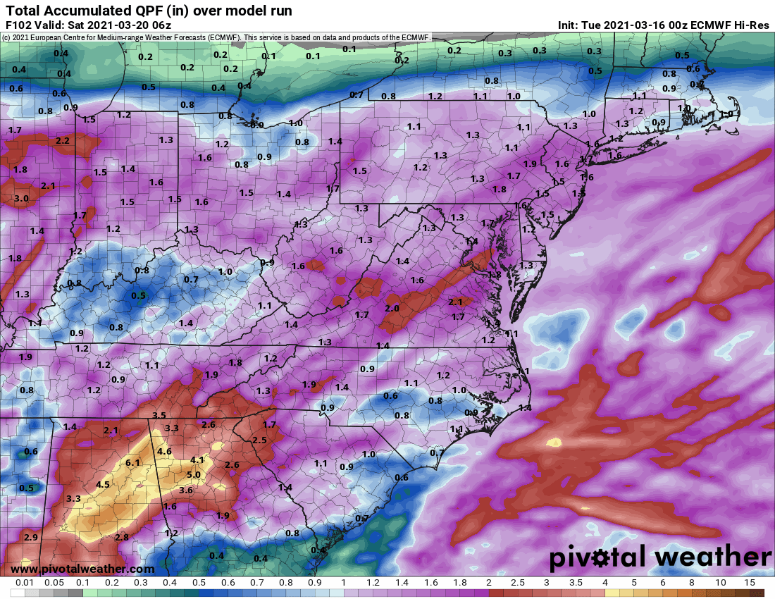
The latest model data has come in a bit drier with less intense precipitation rates, which is problematic for two reasons: obviously less moisture means less precipitation overall, but also,…
Read More
Posted by By Billy DePriest Saturday, February 6, 2021Posted inAlert, Forecast

First Call Forecast – Moderate Snow Likely Sunday

Low pressure will develop across the southeastern US late tomorrow and intensify along the SE coast. The system will pass by to our southeast, during the early morning hours on…
Read More
Posted by By Billy DePriest Friday, February 5, 2021Posted inForecast

Posts pagination

Previous page 1 2 3 4 … 31 Next page
Current Conditions
Current Air Quality Index
Current Radar
Current Satellite
CPC 8-14 Day Temperature Outlook
CPC 8-14 Day Precipitation Outlook
CPC 1 Month Temperature Outlook
CPC 1 Month Precipitation Outlook
Email Subscription
Get the latest blogs emailed to you!


Instagram

maryland_wx

B.S. Meteorology @valparaiso_university | Skywarn Spotter | Providing weather info including forecasts and alerts for the state of Maryland.

🌬 As cold high pressure continues to settle ove 🌬 As cold high pressure continues to settle over the area, Frost and Freeze alerts have been issued for most of the state.

⚠️ A Freeze Warning is in effect for: Baltimore, Carroll, Frederick, and Harford counties...
* IMPACTS...Frost and freeze conditions will kill crops, other sensitive vegetation and possibly damage unprotected outdoor plumbing.

⚠️ A Frost Advisory is in effect for: Anne Arundel, Caroline, Cecil, Charles, Howard, Kent, Montgomery, Prince Georges, Queen Anne's, and Washington counties...
* IMPACTS...Frost could kill sensitive outdoor vegetation if left uncovered.

See https://www.marylandwx.com/alerts/ for more details.
Rainfall associated with Hurricane Ian has entered Rainfall associated with Hurricane Ian has entered southern portions of the state and will continue to move northward this evening. 

Expect periods of moderate to heavy rainfall tonight into early tomorrow morning before tapering to lighter showers through the day. Steadier rainfall may develop again on Sunday, lasting into Sunday evening as the remnant low spins off the coast.

Rainfall totals of 1-2" are likely by Monday morning.
A strong cold front will bring big changes to our A strong cold front will bring big changes to our weather, just in time for the autumnal equinox! The front will cross today with some showers. Behind it, gusty NW winds will bring in much cooler air. Lows tonight and tomorrow night will fall into the 40s for most areas. Highs tomorrow will only reach the mid 60s. Welcome to fall!
Follow on Instagram
Facebook
Cover for Maryland Weather
10,725
Maryland Weather

Maryland Weather

Weather conditions, forecasts, watches and warnings from the National Weather Service and other weather updates for the state of Maryland.

Operated by Billy DePriest


Affiliations
USA Weather Finder
Copyright 2025 — Maryland Weather. All rights reserved.
Scroll to Top