Hazy, hot and humid today; Severe storms possible


A HEAT ADVISORY is in effect for most of Central Maryland.
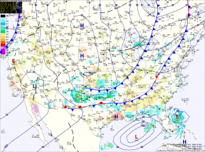

Current Surface Map
Current Surface Map
With high pressure off of the coast, southerly flow will continue to pump heat and humidity into the area. A Heat Advisory has been issued for central Maryland where highs in the mid 90s will combine with dewpoints in the low 70s to push the heat index into the low 100s.

Additionally, the heat and humidity will fuel development of late afternoon and evening thunderstorms. Some of these storms will become severe with damaging winds and large hail as the main threat. Any storm will also be capable of producing very heavy rainfall, leading to localized flash flooding.

Thunderstorms chances will continue tonight and activity will increase again tomorrow afternoon as a cold front approaches from the west. Just like today, these storms will be capable of producing very heavy rainfall, damaging winds and large hail. Highs tomorrow will be in the upper 80s.

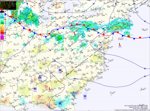
More thunderstorms likely this afternoon

Current Surface Map
Current Surface Map
After a very active night with severe storms moving across the state, a cold front will drop southward into the area and set the stage for another round of strong to severe storms this afternoon.

The main threat with these storms will be very heavy rainfall, damaging winds and large hail. Highs will be in the upper 80s.

The front will press south of the state tonight, ending the storm threat.

The front should remain south of the state tomorrow allowing northwest flow to bring in cooler and drier air. Expect partly sunny skies and highs in the low to mid 80s.