Skip to content
Maryland Weather

Everything you need to know about the weather in Maryland

  • Home
  • Blog Posts
    • Latest Posts
    • Archives
  • Forecasts
    • Local Forecasts
    • Forecast Discussion
  • Station Data
    • Current Data
  • Current Alerts
  • Radar Data
  • Maps & Satellite
    • WPC Maps
    • Satellite
  • Tropical
  • About
  • Subscribe!

heavy rain

Cool and Rainy Start to Memorial Day Weekend

Cool and Rainy Start to Memorial Day Weekend

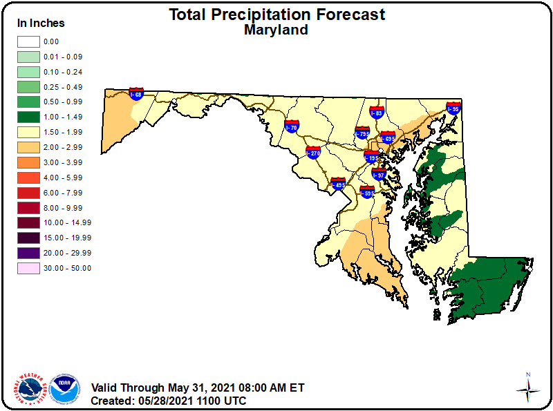
A stalled frontal boundary that is draped across the state this morning will be the focus of rain activity later today into tomorrow as an area of low pressure moves…
Read More
Posted by By Billy DePriest Friday, May 28, 2021Posted inForecast

Remnants of Zeta to Bring Heavy Rain Tomorrow into Friday; Colder this Weekend

Hurricane Zeta, currently in the northern Gulf of Mexico, is expected to make landfall later today in Louisiana, as a Category 2 storm with winds near 100 mph. The storm…
Read More
Posted by By Billy DePriest Wednesday, October 28, 2020Posted inForecast

Tropical Storm Isaias

Good morning! There's quite a bit to get through this morning as Isaias continues to move up the coast, towards our area. First, the latest track from the NOAA NWS…
Read More
Posted by By Billy DePriest Monday, August 3, 2020Posted inAlert, Forecast

Desperately Needed Rain on the Way

An area of low pressure and associated cold front will approach our region tomorrow. At the same, low pressure developing along the Gulf coast will move up along the eastern…
Read More
Posted by By Billy DePriest Tuesday, October 15, 2019Posted inUncategorized

Wintry Mix Ongoing – More Mix to Rain Tonight

Summary: A weak area of low pressure continues to spread a wintry mix across the area this morning. Another, stronger system will bring more precipitation tonight and tomorrow. A wintry…
Read More
Posted by By Billy DePriest Monday, February 11, 2019Posted inAlert, Forecast

Low Pressure Impacts the State Today into Tomorrow

Low pressure containing the remnants of Hurricane Willa will continue to develop and move towards our area today. Rainfall will overspread the state this afternoon, becoming heavy at times tonight…
Read More
Posted by By Billy DePriest Friday, October 26, 2018Posted inForecast

Cold Front and Michael to Bring Periods of Heavy Rain & Wind to the Area

Unlike some of the other major hurricanes that have stalled out after making landfall, Michael hit the Florida panhandle yesterday and has made steady progress northeastward since. The system is…
Read More
Posted by By Billy DePriest Thursday, October 11, 2018Posted inAlert, Forecast

Remnants of Florence Moving Through

As I had mentioned last week, the remnants of Hurricane Florence will pass through our area today and tomorrow bringing showers and thunderstorms. Some of the rainfall could be heavy…
Read More
Posted by By Billy DePriest Monday, September 17, 2018Posted inForecast

Florence Update: Maryland Impact Still Unknown

Hurricane Florence continues to be a very powerful Category 4 hurricane. Maximum sustained winds are 130 mph. Hurricane force winds extend outward up to 40 miles from the center, while…
Read More
Posted by By Billy DePriest Tuesday, September 11, 2018Posted inForecast, Update

What impact will Florence have on Maryland?

Hurricane Florence continues to intensify in the eastern Atlantic as it moves westward towards the east coast. Winds are currently estimated at 115 mph, making Florence a Category 3 storm.…
Read More
Posted by By Billy DePriest Monday, September 10, 2018Posted inForecast

Posts pagination

1 2 3 … 12 Next page
Current Conditions
Current Air Quality Index
Current Radar
Current Satellite
CPC 8-14 Day Temperature Outlook
CPC 8-14 Day Precipitation Outlook
CPC 1 Month Temperature Outlook
CPC 1 Month Precipitation Outlook
Email Subscription
Get the latest blogs emailed to you!


Instagram

maryland_wx

B.S. Meteorology @valparaiso_university | Skywarn Spotter | Providing weather info including forecasts and alerts for the state of Maryland.

🌬 As cold high pressure continues to settle ove 🌬 As cold high pressure continues to settle over the area, Frost and Freeze alerts have been issued for most of the state.

⚠️ A Freeze Warning is in effect for: Baltimore, Carroll, Frederick, and Harford counties...
* IMPACTS...Frost and freeze conditions will kill crops, other sensitive vegetation and possibly damage unprotected outdoor plumbing.

⚠️ A Frost Advisory is in effect for: Anne Arundel, Caroline, Cecil, Charles, Howard, Kent, Montgomery, Prince Georges, Queen Anne's, and Washington counties...
* IMPACTS...Frost could kill sensitive outdoor vegetation if left uncovered.

See https://www.marylandwx.com/alerts/ for more details.
Rainfall associated with Hurricane Ian has entered Rainfall associated with Hurricane Ian has entered southern portions of the state and will continue to move northward this evening. 

Expect periods of moderate to heavy rainfall tonight into early tomorrow morning before tapering to lighter showers through the day. Steadier rainfall may develop again on Sunday, lasting into Sunday evening as the remnant low spins off the coast.

Rainfall totals of 1-2" are likely by Monday morning.
A strong cold front will bring big changes to our A strong cold front will bring big changes to our weather, just in time for the autumnal equinox! The front will cross today with some showers. Behind it, gusty NW winds will bring in much cooler air. Lows tonight and tomorrow night will fall into the 40s for most areas. Highs tomorrow will only reach the mid 60s. Welcome to fall!
Follow on Instagram
Facebook
Cover for Maryland Weather
10,725
Maryland Weather

Maryland Weather

Weather conditions, forecasts, watches and warnings from the National Weather Service and other weather updates for the state of Maryland.

Operated by Billy DePriest


Affiliations
USA Weather Finder
Copyright 2025 — Maryland Weather. All rights reserved.
Scroll to Top