Skip to content
Maryland Weather

Everything you need to know about the weather in Maryland

  • Home
  • Blog Posts
    • Latest Posts
    • Archives
  • Forecasts
    • Local Forecasts
    • Forecast Discussion
  • Station Data
    • Current Data
  • Current Alerts
  • Radar Data
  • Maps & Satellite
    • WPC Maps
    • Satellite
  • Tropical
  • About
  • Subscribe!

damaging winds

Today: Record warmth and windy, then showers and storms as cold front crosses

Today: Record warmth and windy, then showers and storms as cold front crosses

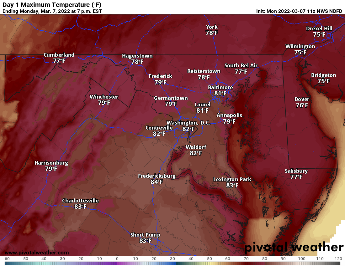
Strong southwesterly winds will continue to bring record warm air into our area today. Highs will be in the upper 70s to low 80s across most of the state, including…
Read More
Posted by By Billy DePriest Monday, March 7, 2022Posted inAlert, Forecast

Halloween Forecast Update

Scattered showers will push through the state over the next few hours, into the evening hours. This rainfall will be spotty and generally light, but may impact trick-or-treaters this evening.…
Read More
Posted by By Billy DePriest Thursday, October 31, 2019Posted inForecast, Update

Powerful Nor’Easter to Bring Rain, Strong Winds, and Coastal Flooding to the State

--- A *HIGH WIND WARNING* has been issued for: Allegany, Anne Arundel, Calvert, Charles, Frederick, Howard, Montgomery, Prince George's, St. Mary's, and Washington counties. --- A *WINTER WEATHER ADVISORY* has…
Read More
Posted by By Billy DePriest Thursday, March 1, 2018Posted inAlert, Forecast

Continued Hot and Humid with Scattered Showers and Storms Today & Tomorrow

Summary: A cold front will approach our area today and move through tomorrow. High pressure builds in Sunday and persists into next week. A hot and humid airmass remains in…
Read More
Posted by By Billy DePriest Friday, July 8, 2016Posted inForecast

Showers & Storms Bookend Holiday Weekend

Summary: High pressure off the coast will keep warm and humid air in place today as a cold front moves in from the west. The front will pass through tonight. High…
Read More
Posted by By Billy DePriest Friday, July 1, 2016Posted inForecast

Strong to Severe Storms Tonight & Tomorrow

  An area of low pressure responsible for the severe weather threat over the midwest today will move into our area tonight, traveling along a frontal boundary that is draped…
Read More
Posted by By Billy DePriest Wednesday, June 22, 2016Posted inForecast

Scattered Showers and Possibly Severe Storms Today

Summary: A cold front will pass through later today. High pressure briefly controls the weather tomorrow followed by low pressure on Thursday. High pressure returns for the weekend. A cold…
Read More
Posted by By Billy DePriest Tuesday, June 21, 2016Posted inForecast

Scattered Showers and Storms Today and Tonight; Locally Heavy Rain Possible

Summary: An area of low pressure will move by to our south today through tonight moving off the coast tomorrow. High pressure will return for the weekend. A few waves…
Read More
Posted by By Billy DePriest Thursday, June 16, 2016Posted inAlert, Forecast

Strong to Severe Storms Likely this Afternoon and Evening

A cold front moving into the area will trigger scattered showers and thunderstorms today into tonight. The Mid Atlantic region is remains under the gun for strong to severe storms…
Read More
Posted by By Billy DePriest Sunday, June 5, 2016Posted inForecast

Warm and Humid Today with Afternoon Showers and Storms

Summary: A cold front will move into the area today and pass through this evening. The front will then stall out to our south tomorrow evening through Friday. High pressure…
Read More
Posted by By Billy DePriest Tuesday, April 26, 2016Posted inForecast

Posts pagination

1 2 3 … 5 Next page
Current Conditions
Current Air Quality Index
Current Radar
Current Satellite
CPC 8-14 Day Temperature Outlook
CPC 8-14 Day Precipitation Outlook
CPC 1 Month Temperature Outlook
CPC 1 Month Precipitation Outlook
Email Subscription
Get the latest blogs emailed to you!


Instagram

maryland_wx

B.S. Meteorology @valparaiso_university | Skywarn Spotter | Providing weather info including forecasts and alerts for the state of Maryland.

🌬 As cold high pressure continues to settle ove 🌬 As cold high pressure continues to settle over the area, Frost and Freeze alerts have been issued for most of the state.

⚠️ A Freeze Warning is in effect for: Baltimore, Carroll, Frederick, and Harford counties...
* IMPACTS...Frost and freeze conditions will kill crops, other sensitive vegetation and possibly damage unprotected outdoor plumbing.

⚠️ A Frost Advisory is in effect for: Anne Arundel, Caroline, Cecil, Charles, Howard, Kent, Montgomery, Prince Georges, Queen Anne's, and Washington counties...
* IMPACTS...Frost could kill sensitive outdoor vegetation if left uncovered.

See https://www.marylandwx.com/alerts/ for more details.
Rainfall associated with Hurricane Ian has entered Rainfall associated with Hurricane Ian has entered southern portions of the state and will continue to move northward this evening. 

Expect periods of moderate to heavy rainfall tonight into early tomorrow morning before tapering to lighter showers through the day. Steadier rainfall may develop again on Sunday, lasting into Sunday evening as the remnant low spins off the coast.

Rainfall totals of 1-2" are likely by Monday morning.
A strong cold front will bring big changes to our A strong cold front will bring big changes to our weather, just in time for the autumnal equinox! The front will cross today with some showers. Behind it, gusty NW winds will bring in much cooler air. Lows tonight and tomorrow night will fall into the 40s for most areas. Highs tomorrow will only reach the mid 60s. Welcome to fall!
Follow on Instagram
Facebook
Cover for Maryland Weather
10,725
Maryland Weather

Maryland Weather

Weather conditions, forecasts, watches and warnings from the National Weather Service and other weather updates for the state of Maryland.

Operated by Billy DePriest


Affiliations
USA Weather Finder
Copyright 2025 — Maryland Weather. All rights reserved.
Scroll to Top