Current Surface MapA cold front will approach from the west today while high pressure off the coast continues to push warm and humid air out ahead of it. The combination of the two will trigger numerous showers and thunderstorms today. There is a slight chance that some of the storms could become severe this afternoon, with damaging wind being the primary threat. Highs today will top out around 80 degrees.
The shower threat will be ongoing tonight as the front continues to push into the area. The front will cross late tonight or early tomorrow morning.
Showers will linger through tomorrow behind the front, with highs only reaching the mid 60s.
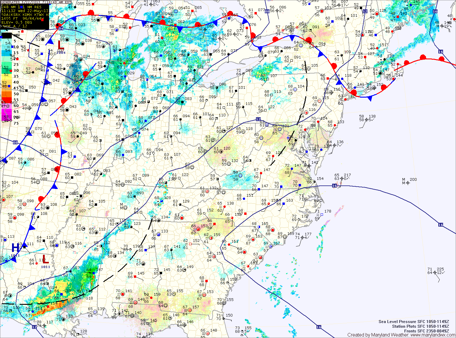
Current Surface MapHigh pressure off the coast will continue the warmth and humidity today. Highs will push into the mid to upper 80s. High dew points will make it feel even warmer. Additionally, scattered showers and thunderstorms are expected this afternoon. Some of the storms could produce strong gusty winds.
A better chance of more wide spread showers and thunderstorms tomorrow, as the cold front responsible for the severe weather over the Plains and Midwest finally pushes into our area. There is a slight chance the storms could be severe with damaging winds being the main threat. Highs tomorrow will be in the mid 80s.
Current Surface MapHigh pressure will slide off the coast today, providing another sunny day today and for the majority of tomorrow. Highs today will be around 80 degrees.
A cold front will approach tomorrow afternoon and isolated showers and thunderstorms will develop ahead of it. Expect a mostly sunny, breezy and warm day with highs into the mid 80s.
Clouds will increase late in the afternoon as the showers and thunderstorms move through. Strong gusty winds are possible with any storm that develops.
The front will clear the state during the overnight and cool Canadian air will filter in behind it. Sunday will be mostly sunny with highs around 70 degrees.
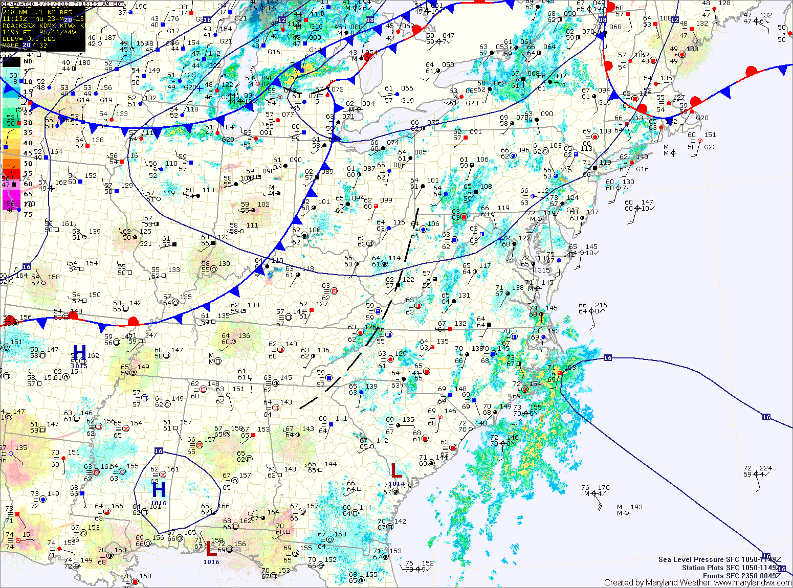
Current Surface MapHigh pressure will be pushed off the coast today as a warm front moves northward through the state. Clouds will increase through the day and there is a chance of rain later this afternoon into tonight. Highs today will be in the mid 70s.
A cold front to the west will combine with an area of low pressure to our southwest to bring widespread rainfall to the area. Showers and thunderstorms are likely tonight through tomorrow night.
Expect a breezy day tomorrow, with locally heavy rainfall. Rain totals well over 2 inches will possible in many areas. Additionally, strong to severe damaging wind will be possible with any thunderstorms that develop. Highs will be in the mid to upper 70s.
Current Surface MapHigh pressure will deliver a mostly sunny day today with highs around 90 degrees.
The high pressure will be pushed off shore as a strong cold front approaches and move through the area tomorrow bringing numerous showers and thunderstorms to the state.
Some of these storms could become strong to severe tomorrow afternoon, with damaging wind gusts as the primary threat.
Stay alert tomorrow for possible watches and warnings as storms develop through the day.
Current Surface MapAs high pressure moves off the coast today, warm humid air will continue to flow into the area.
The airmass will support the development of isolated showers and thunderstorms this afternoon. Highs will be in the mid 90s with heat index values around 100.
More of the same tomorrow, hot and humid with scattered afternoon thunderstorms. Highs will be in the low to mid 90s.
THE NWS STORM PREDICTION CENTER HAS ISSUED A SEVERE THUNDERSTORM WATCH EFFECTIVE THIS WEDNESDAY AFTERNOON AND EVENING FROM 1245 PM UNTIL 900 PM EDT. HAIL TO 1.5 INCHES IN DIAMETER...THUNDERSTORM WIND…
Current Surface MapAs low pressure continues to move through, the atmosphere remains moist and will become unstable this afternoon. As the current round of rain continues to move out, expect a decrease in clouds allowing some peaks of sunshine causing temperatures to warm into the mid 70s.
This will set the stage for another round of scattered showers and thunderstorms this afternoon. Some of the storms may become strong to severe with damaging winds.
The associated cold front will pass through tomorrow afternoon. Ahead of the front, showers and storms will again be possible. Highs tomorrow will be near 80. The front will clear the area during the afternoon, ending the rain chances and ushering in drier air.
Current Surface MapWarm and humid air continues to build into the region, setting the stage and allowing for scattered showers and thunderstorms to develop this afternoon. Skies are expected to clear this afternoon, allowing temperatures to warm to near 80 and enhancing the instability in the atmosphere.
It appears that there will be enough instability for some of these storms to become severe, with damaging winds and hail.