Cloudy and cooler with drizzle and light rain today
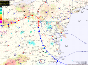
Current Surface Map
Current Surface Map
A backdoor cold front has pushed in from the northeast and easterly flow off the Atlantic has brought in cool and moist air. Expect areas of fog, mist and drizzle this morning, continuing through the afternoon. Isolated heavier showers are possible this afternoon as well. Highs will only top out in the low 60s.

Areas of fog will develop tonight as the easterly flow continues.

As we head into tomorrow, high pressure will begin to build in from the northwest. This will scour out the moisture and turn the flow to a more northerly direction. As a result, expect morning clouds to break allowing some afternoon sunshine. There is a slight chance of a shower during the late afternoon, but most areas will remain dry. Highs will be in the low to mid 70s.

Warming up

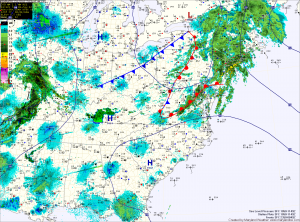
Current Surface Map
An area of low pressure is moving by to the north, dragging a warm front through the state today, followed by a weak cold frontal passage later this afternoon. Scattered showers and thunderstorms will be possible with these two features. Highs today will push into the upper 70s to near 80.

High pressure off the coast will pump warm and humid air into the region tomorrow, setting the stage for more scattered showers and thunderstorms. Highs will be in the mid 70s.

A backdoor cold front will approach Wednesday night and Thursday. This will enhance an easterly flow and cause areas along the Bay to cool. Highs Thursday will be near 70 along and east of the Bay and will rise into the 80s west of I-95. Showers and thunderstorms will be possible again Thursday afternoon.