Skip to content
Maryland Weather

Everything you need to know about the weather in Maryland

  • Home
  • Blog Posts
    • Latest Posts
    • Archives
  • Forecasts
    • Local Forecasts
    • Forecast Discussion
  • Station Data
    • Current Data
  • Current Alerts
  • Radar Data
  • Maps & Satellite
    • WPC Maps
    • Satellite
  • Tropical
  • About
  • Subscribe!

Blog Posts

Potential Winter Storm – Sunday into Monday

Potential Winter Storm – Sunday into Monday

Model Comparison GFS - 7PM Sunday EveningEuropean - 10PM Sunday Night More to details to come in the coming days. Stay tuned!
Read More
Posted by By Billy DePriest Tuesday, January 11, 2022Posted inOutlook
Light to Moderate Snow This Evening into Tomorrow Morning

Light to Moderate Snow This Evening into Tomorrow Morning

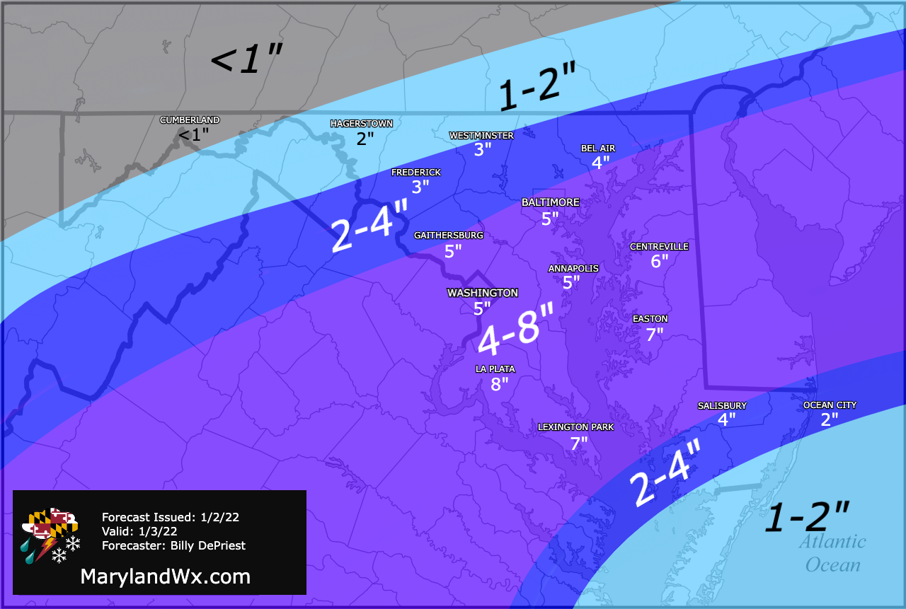
Here is the latest on the system that will impact our area this evening through tomorrow morning... Winter Storm Warnings (pink) and Winter Weather Advisories (purple) are in effect Snowfall…
Read More
Posted by By Billy DePriest Thursday, January 6, 2022Posted inAlert, Forecast, Update
Light to Moderate Snow Likely late Tomorrow Night into Friday

Light to Moderate Snow Likely late Tomorrow Night into Friday

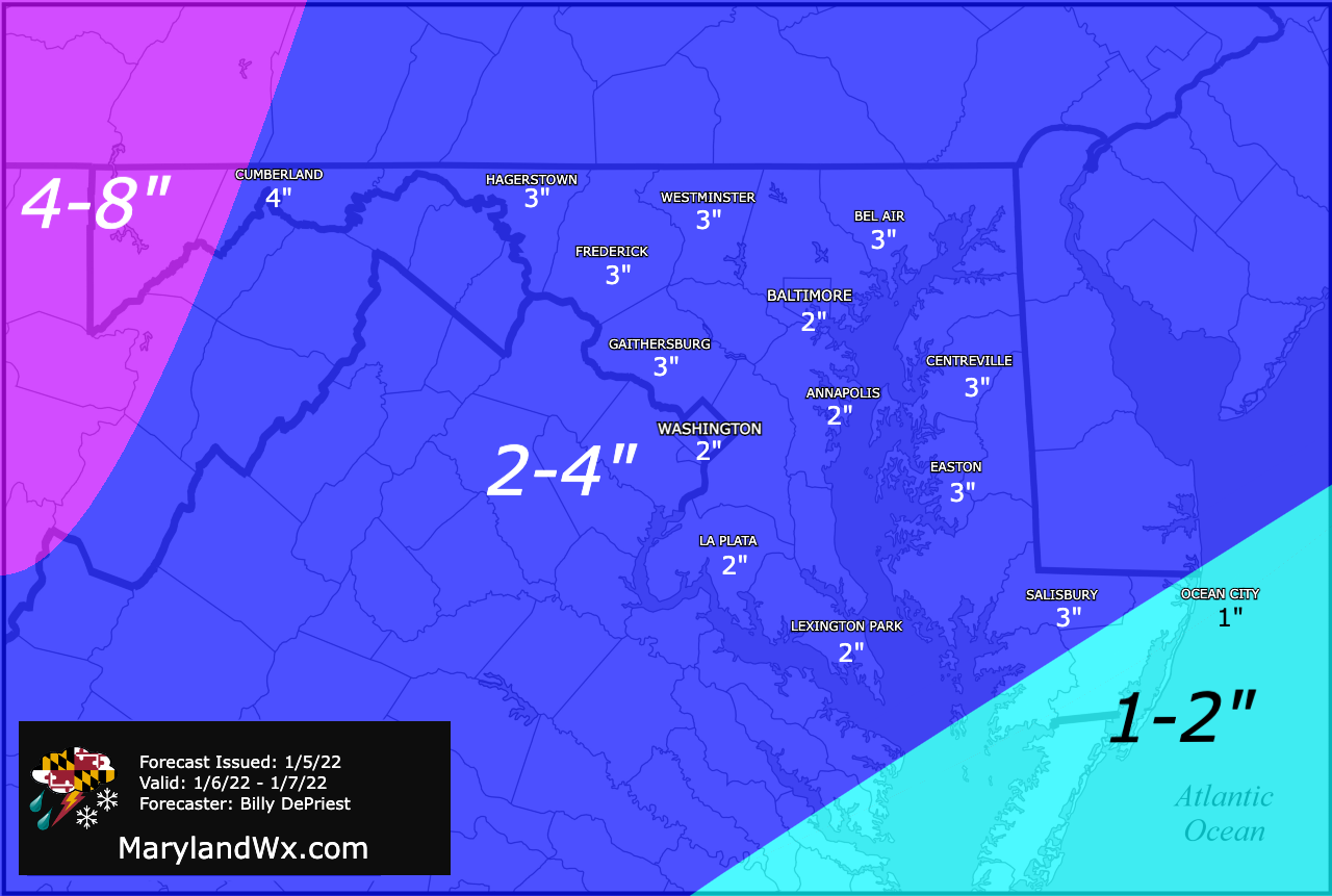
Wednesday Afternoon Update: Here is the latest on the snowfall that is expected tomorrow into Friday, including: overview, timing, model output, and snowfall forecast... Timing - from the 12z NAM…
Read More
Posted by By Billy DePriest Wednesday, January 5, 2022Posted inForecast, Outlook
Winter Storm Update – 1/2/22

Winter Storm Update – 1/2/22

Here is the latest on the winter storm that will affect our area tomorrow... Previous update below...
Read More
Posted by By Billy DePriest Sunday, January 2, 2022Posted inAlert, Forecast
Remnants of Ida to Bring Flooding Rains to Our Area

Remnants of Ida to Bring Flooding Rains to Our Area

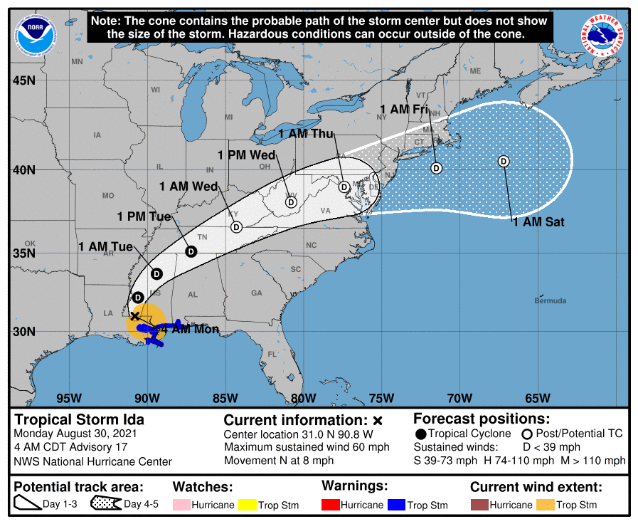
Hurricane Ida made landfall in Louisiana yesterday as a Category 4 storm and has since moved inland and weakened to a tropical storm. The system will continue to weaken as…
Read More
Posted by By Billy DePriest Monday, August 30, 2021Posted inAlert, Forecast
Cool and Rainy Start to Memorial Day Weekend

Cool and Rainy Start to Memorial Day Weekend

A stalled frontal boundary that is draped across the state this morning will be the focus of rain activity later today into tomorrow as an area of low pressure moves…
Read More
Posted by By Billy DePriest Friday, May 28, 2021Posted inForecast
Cool and Cloudy; Widespread Rainfall Thursday into Friday

Cool and Cloudy; Widespread Rainfall Thursday into Friday

Weak low pressure will continue to push through our area today, keeping us cool and cloudy, with an occasional sprinkle possible. We will warm a little tomorrow, with highs in…
Read More
Posted by By Billy DePriest Tuesday, March 16, 2021Posted inForecast, Outlook
A Return To Normalcy

A Return To Normalcy

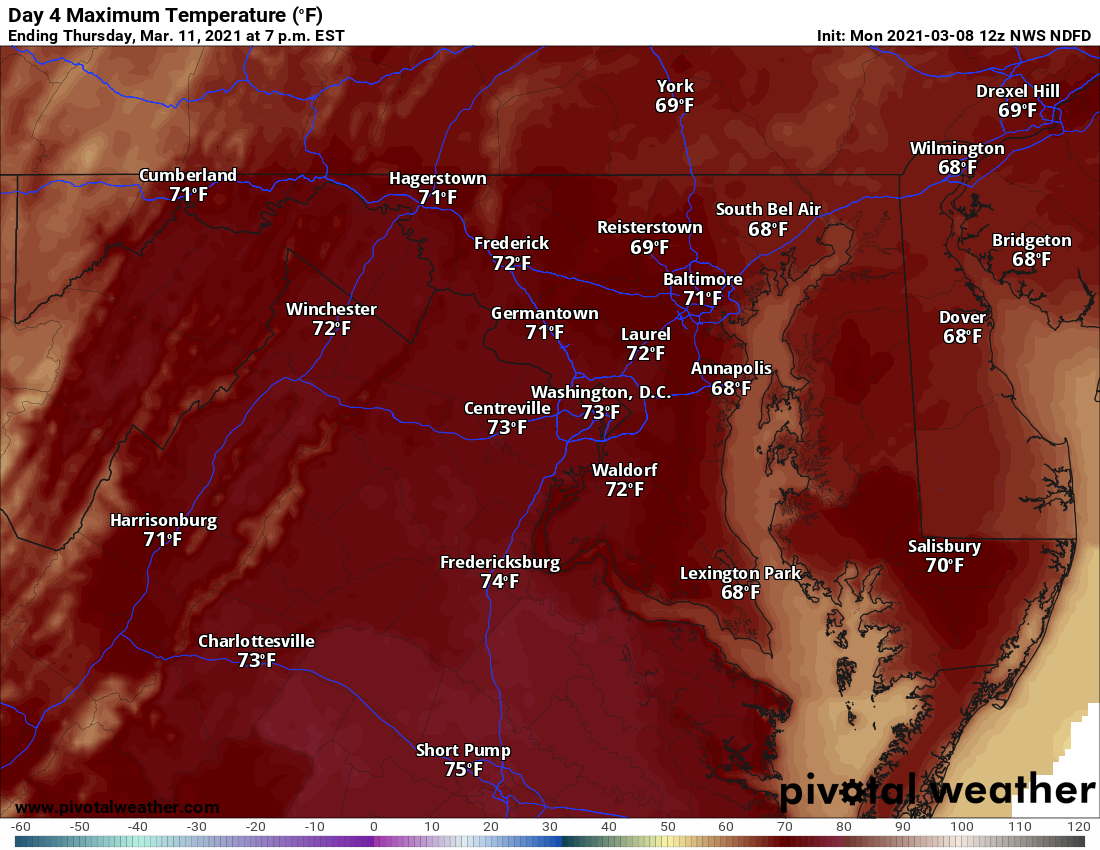
After a very mild and dry week, culminating with record highs yesterday, a cold front is currently moving through the state, bringing clouds, a few sprinkles, and by this evening,…
Read More
Posted by By Billy DePriest Friday, March 12, 2021Posted inForecast, Outlook
A Warm and Dry Week Ahead

A Warm and Dry Week Ahead

Our stretch of dry weather continues this week, as we begin the advertised warm up. Today will be the coolest day, with highs generally in the low to mid 50s.…
Read More
Posted by By Billy DePriest Monday, March 8, 2021Posted inForecast, Outlook
A Rare Prolonged Dry Stretch

A Rare Prolonged Dry Stretch

It's pretty rare these days to see a stretch of dry weather like we are entering now with no meaningful precipitation expected over the next week. The sunshine and prolonged…
Read More
Posted by By Billy DePriest Tuesday, March 2, 2021Posted inForecast, Outlook

Posts pagination

Previous page 1 2 3 4 5 … 127 Next page
Instagram

maryland_wx

B.S. Meteorology @valparaiso_university | Skywarn Spotter | Providing weather info including forecasts and alerts for the state of Maryland.

🌬 As cold high pressure continues to settle ove 🌬 As cold high pressure continues to settle over the area, Frost and Freeze alerts have been issued for most of the state.

⚠️ A Freeze Warning is in effect for: Baltimore, Carroll, Frederick, and Harford counties...
* IMPACTS...Frost and freeze conditions will kill crops, other sensitive vegetation and possibly damage unprotected outdoor plumbing.

⚠️ A Frost Advisory is in effect for: Anne Arundel, Caroline, Cecil, Charles, Howard, Kent, Montgomery, Prince Georges, Queen Anne's, and Washington counties...
* IMPACTS...Frost could kill sensitive outdoor vegetation if left uncovered.

See https://www.marylandwx.com/alerts/ for more details.
Rainfall associated with Hurricane Ian has entered Rainfall associated with Hurricane Ian has entered southern portions of the state and will continue to move northward this evening. 

Expect periods of moderate to heavy rainfall tonight into early tomorrow morning before tapering to lighter showers through the day. Steadier rainfall may develop again on Sunday, lasting into Sunday evening as the remnant low spins off the coast.

Rainfall totals of 1-2" are likely by Monday morning.
A strong cold front will bring big changes to our A strong cold front will bring big changes to our weather, just in time for the autumnal equinox! The front will cross today with some showers. Behind it, gusty NW winds will bring in much cooler air. Lows tonight and tomorrow night will fall into the 40s for most areas. Highs tomorrow will only reach the mid 60s. Welcome to fall!
Follow on Instagram
Facebook
Cover for Maryland Weather
10,725
Maryland Weather

Maryland Weather

Weather conditions, forecasts, watches and warnings from the National Weather Service and other weather updates for the state of Maryland.

Operated by Billy DePriest


Affiliations
USA Weather Finder
Copyright 2025 — Maryland Weather. All rights reserved.
Scroll to Top