
 Summary: High pressure off the coast will keep warm and humid air in place today as a cold front moves in from the west. The front will pass through tonight. High pressure returns tomorrow into Sunday before low pressure impacts our area on Monday.
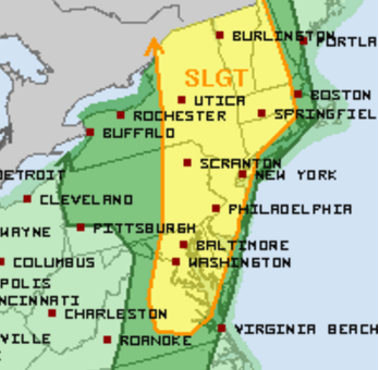
Warm humid air will interact with a cold front approaching from the west to touch off showers and thunderstorms this afternoon and evening. Some of the storms could turn strong to severe with large hail, damaging wind and isolated tornadoes. Stay alert this afternoon, especially in the 3pm to 8pm timeframe. This is when the strongest of the storms are expected.
The front will clear tonight, ending the rain threat and allowing high pressure to build in.
The cold front will stall out to our south this weekend as high pressure builds in tomorrow and Sunday. Highs will be in the low to mid 80s both days.
Low pressure is expected to develop and move along the front, bringing another threat of showers and thunderstorms on Monday. Showers and storms are likely Monday night as the low moves through which could unfortunately impact area firework shows.