
Summary: A strong storm system will move up the Ohio Valley today, pushing a warm front into our area this afternoon followed by a cold front tonight. High pressure builds in for the rest of the week.
--------------------------------------------

3:30pm Update:
The entire state east of Washington county is now under a Tornado Watch valid through this evening:
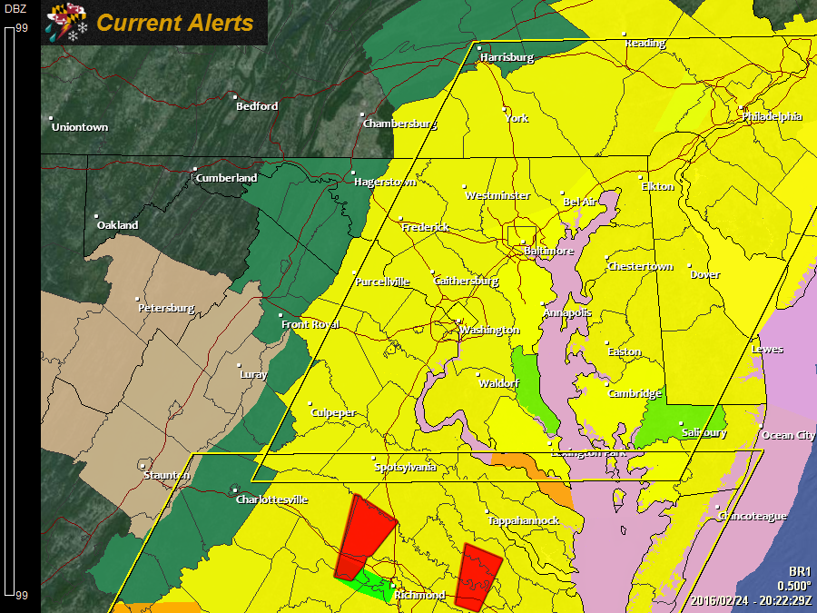
Here is an excerpt from the Storm Prediction Center:
 * PRIMARY THREATS INCLUDE...

     A FEW TORNADOES AND A COUPLE INTENSE TORNADOES POSSIBLE

     SCATTERED DAMAGING WIND GUSTS TO 70 MPH LIKELY
SUMMARY...A LINE OF STRONG TO SEVERE STORMS WILL QUICKLY PROGRESS
NORTHEASTWARD ACROSS THE MID-ATLANTIC REGION THROUGH THIS EVENING.
DAMAGING WINDS AND A FEW TORNADOES WILL BE THE MAIN HAZARDS.
For more information, check out the Alerts page: https://www.marylandwx.com/alerts/
--------------------------------------------

1:00pm Update:
The Storm Prediction Center has bumped the risk for severe weather in our area. They have upgraded the threat this afternoon and evening to an “Enhanced” risk:
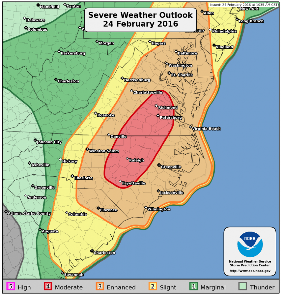
Possible threats include: tornadoes, damaging winds and isolated large hail in addition to torrential downpours
For more information see: http://www.spc.noaa.gov/products/outlook/pwo.html
Stay alert for possible watches and warnings later this afternoon and evening.
--------------------------------------------
Original Post:
- A Flood Watch is in effect for: Allegany, Anne Arundel, Baltimore, Baltimore City, Carroll, Frederick, Harford, Howard, Montgomery, Prince George's and Washington counties
- A Freezing Rain Advisory is in effect for: Western Allegany and Garrett counties
Strong low pressure that has been responsible for severe weather along the Gulf Coast will move northward today into the Ohio Valley. The low will continue to spread rainfall into our area through the day today and into tonight. Additionally, as instability increases this afternoon, there is a threat for strong to possibly severe thunderstorms. The main threat from these storms will be locally heavy rainfall and damaging wind gusts. The most likely timing for storms will be during the afternoon and evening hours.
The cold front will slide through tonight, ending the storm and rain threat.
Wrap around snow showers in the mountains and isolated rain showers elsewhere will be possible tomorrow as the storm pulls away.
Here is a simulated radar from the WRF, showing the possible timing and location of the storms from 1pm this afternoon to 11pm tonight:
[slideshow_deploy id=’11221′]
Behind the system, high pressure returns and persists into the weekend. As a result, expect mostly sunny skies and a warming trend Friday through Sunday.