
 ---
---
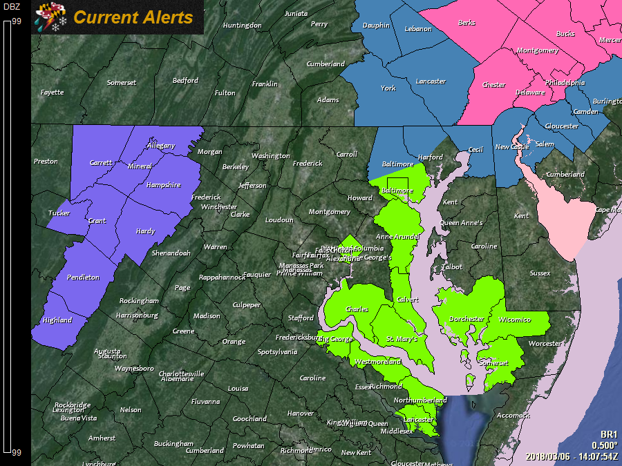
A *WINTER STORM WATCH* has been issued for: Northern Baltimore, Cecil, and Northern Harford counties.
---
A *WINTER WEATHER ADVISORY* has been issued for Garrett and Allegany counties.
---
A *COASTAL FLOOD ADVISORY* has been issued for: Anne Arundel, Baltimore, Calvert, Charles, Dorchester, Somerset, St. Mary's, and Wicomico counties.
---
As the clean up continues from the last storm, another nor’easter is poised to affect portions of the east coast. This storm will not have winds as strong as the last, but it will have more cold air to work with which will result in heavy snowfall along I-95, mainly from Philadelphia to Boston.
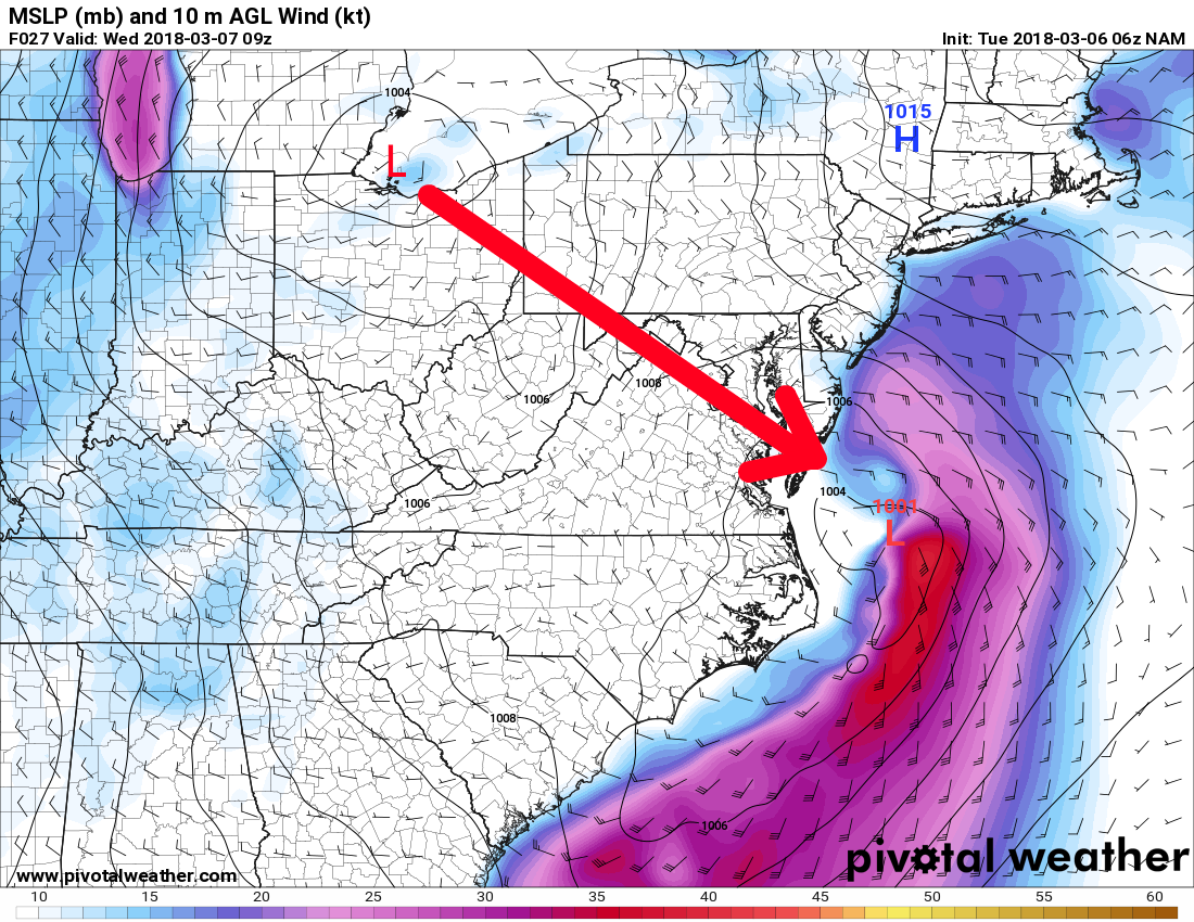
This storm is what is called a “Miller B” type storm, where an area of low pressure over the Ohio Valley transfers energy to low pressure along the coastline. These types of storms generally do not bring significant snowfall the majority of our area, as they tend to develop and strengthen too far north, generally impacting areas to our north and east more significantly. This system will be no exception, which is why only the northeast portion of our state will see significant snowfall.
Here is an illustration of the Miller B aspect of this storm. The area of low pressure over northern Ohio will “die out” as its energy transfers to the low pressure developing off Virginia Beach:
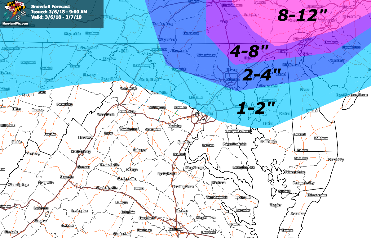
As for what we can expect here in Maryland,light rain or rain/snow mix is possible late this afternoon or early evening as the energy transfers to the coast. Heavier snowfall will then develop mainly across northeast Maryland overnight into tomorrow morning as the coastal low strengthens off of the Delaware/New Jersey coastline. The storm will continue to strengthen as it moves northeast and away from our area tomorrow afternoon and snowfall will taper off and end.
While most of the state will be spared the heavy snow, I still expect perhaps an inch or two across central Maryland, with amounts increasing as you move north and east with 4″ to perhaps isolated spots up to 8″ possible in far north eastern Maryland. Further north, into eastern Pennsylvania snowfall totals of over a foot are likely. Additionally, as the storm strengthens, expect winds to increase, gusting to 20-25 mph tomorrow and tomorrow night.
As illustrated above, this is a complex set up. The development and location of the coastal low will ultimately determine how much snow falls in our area. I will issue a forecast update later today if warranted.
Want the latest blog posts emailed to you?