
 An area of low pressure responsible for the severe weather threat over the midwest today will move into our area tonight, traveling along a frontal boundary that is draped across the state.
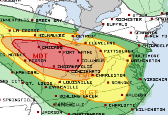
Shower and thunderstorms are likely later tonight with some of the storms becoming strong to severe with damaging winds and locally heavy rainfall as the main threats. Flash flooding is a possibility as storms move over the same areas.
The storm threat will carry over into tomorrow morning before clearing out.
Another low pressure system and cold front will move into and through the area late tomorrow. This system will interact with moisture left over from the morning storms combined with afternoon temperatures in the mid to upper 80s to produce another round of showers and storms. The storms could become severe again, with damaging winds and locally heavy rainfall.
The front will move south of our area tomorrow night, ending the rain threat.
High pressure will slowly build in on Friday and persist through the weekend.