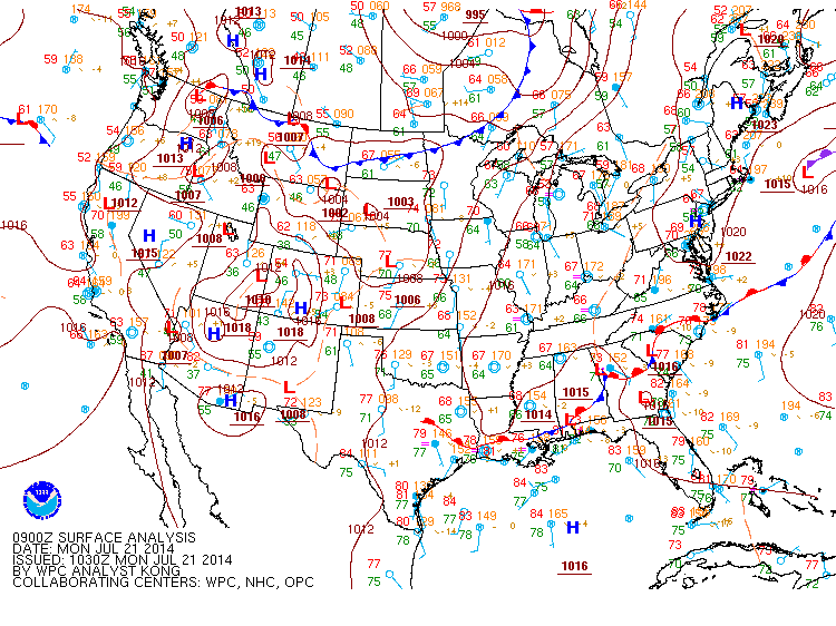
Mostly sunny today; Showers and thunderstorms likely tomorrow through the weekend

Current Surface Map
Current Surface Map
High pressure centered just off of the coast will provide the area with one more day of dry weather before a pattern change gets underway. Highs today will be in the mid 80s.

The high will get pushed eastward tonight by an upper level trough. This trough will bring showers to the area beginning late tonight through tomorrow. There may be a few rumbles of thunder tomorrow afternoon. Highs tomorrow will be in the low 80s.

Showers will remain likely tomorrow night, with some thunder also possible. Rain chances will continue Saturday and will increase in coverage during the late afternoon and evening. Highs will be around 80.

Sunny today; Heat and humidity return this weekend; Storms likely Sunday

Current Surface Map
Current Surface Map
High pressure has moved into the region and as a result, expect mostly sunny skies today with highs in the low to mid 80s.

The high will slide off of the coast tonight into tomorrow. This will allow warmer, more humid air to flow back into the area. Expect highs to be in the upper 80s to around 90 under mostly sunny skies.

A disturbance will move into the area Saturday night and Sunday, bringing a chance of showers and thunderstorms. Some of the storms could be strong to severe on Sunday with damaging winds being the most likely threat. The storms will also be capable of producing heavy rainfall, leading to localized flash flooding. Highs will be in the mid to upper 80s.

Cold front moving through today; Cooler and drier tomorrow

Current Surface Map
Current Surface Map
A cold front continues to work it’s way through the state this morning. As it does, scattered showers will be possible, mainly this morning before the front finally moves south this afternoon. Highs today will top out in the low to mid 80s.

High pressure will build into the area tomorrow, leading to a nice day with highs in the low 80s, lower humidity and mostly sunny skies.

The high will shift off of the coast tomorrow night into Saturday. As a result warmer and more humid air will return. Highs on Saturday will be around 90 with a slight chance of an afternoon thunderstorm.

Partly sunny today; Thunderstorms likely this evening and tonight

Current Surface Map
Current Surface Map
A cold front is slowly moving towards the region today. As it moves closer, showers and thunderstorms will become likely late this afternoon and into tonight. Highs today will be around 90.

The front will continue its progression eastward tomorrow, keeping shower and thunderstorm chances in the forecast through the evening hours. Highs will be in the low to mid 80s.

The front will push through late tomorrow evening, ushering in high pressure and and drier air for the end of the week.

Friday will be mostly sunny with highs in the mid 80s.

Warm and humid today; Cold front crosses Thursday

Current Surface Map
Current Surface Map
With high pressure parked off of the coast, expect another day of warm and humid conditions. An isolated shower or thunderstorm is possible this afternoon, especially over the mountains. Highs will be in the upper 80s.

A cold front will begin its approach on Wednesday. It will continue to be warm, with highs around 90 under partly sunny skies.

The front will move close enough to the area to set off scattered thunderstorms late Wednesday into Wednesday night. The storm activity will continue Thursday as the front moves into the area. Highs will be in the low 80s.

The front will push through during the day Thursday, ushering in cooler and drier air for the end of the week.

Heat and humidity build through mid-week; Cold front crosses Thursday

Current Surface Map
Current Surface Map
High pressure just off of the east coast will cause temperatures and humidity to rise for the first half of the week.

Today will be partly sunny with isolated showers and thunderstorms. It will be more humid, with highs in the low to mid 80s.

Tomorrow will be warmer and more humid than today with a slight chance of an afternoon thunderstorm. Highs will be in the upper 80s to near 90.

Wednesday will be similar to Tuesday with highs around 90 with a slightly better chance of afternoon and evening storms.

Mostly sunny today. Dry through the weekend

Current Surface Map
Current Surface Map
High pressure will remain in control of the weather today and through this weekend. Expect mostly sunny skies today with highs in the low to mid 80s.

The high will slide off the coast tomorrow and onshore flow will develop, mainly in eastern and central Maryland. This will keep any shower or thunderstorm activity confined to the mountains. Highs will be in the low 80s under partly sunny skies.

Sunday will be similar to Saturday with isolated showers and storms in the mountains, partly sunny skies further east. Highs will be in the low to mid 80s.