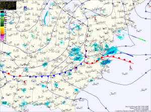
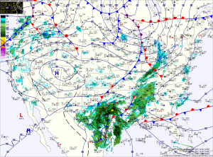
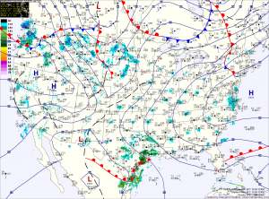
Light Snow Develops This Afternoon

Current Surface Map
Current Surface Map
A Winter Weather Advisory is in effect for all of Maryland, except for Garrett County, where a Winter Storm Warning is in effect.

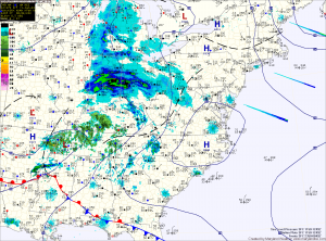
A weak storm system will spread light snow over the state this afternoon from west to east. 4-6 inches of snow are expected over Garrett County, while 1-3 inches are expected within the Advisory areas.

There could be isolated higher amounts, especially across northern Maryland and Southern Maryland.

The snow will begin to wind down tonight, tapering to flurries and ending between 10pm and midnight.

Clearing Today; More Light Snow Tomorrow

Current Surface Map
Current Surface Map
As one over-performing storm departs, another will bring more snow to the area tomorrow. In between, expect a sunny but cold and windy day today. Highs will top out in the mid to upper 20s.

Last night’s clipper brought a dusting to northern parts of the state, while nearly 5 inches of snow fell across southern St. Mary’s county. Totals across central Maryland of 1-2″ were common.

The next system will have a bit more moisture with it, but will be a fast mover. Expect snow to develop during the afternoon and last into tomorrow night. Snowfall totals of 1-3″ are expected at this time, impacting the evening rush hour.

Behind that system, a cold and dry weekend is on tap. Highs on Saturday will push to near freezing, pushing into the mid 30s on Sunday.

Cold Again Today; Light Snow Tonight, again Friday

Current Surface Map
Current Surface Map
After a Tuesday in which we didn’t break the mid 20s, a cold Wednesday will follow. Expect similar temperatures to yesterday, with less wind. Highs today will be in the mid 20s.

A weak Alberta Clipper will move through tonight, bringing a chance of light snow to the area. Overnight accumulations of a dusting to possibly an inch in spots is possible.

The clipper moves out tomorrow, giving way to mostly sunny skies with highs in the upper 20s to around 30.

Clouds increase again on Friday ahead of the next storm system that looks to bring light snow to the area Friday afternoon into Friday night. Highs Friday wil be in the upper 20s.

Very Cold and Windy; Chance of Wintry Precip on Friday

Current Surface Map
Current Surface Map
Following a cold frontal passage yesterday, bitterly cold air has spilled into the region on strong northwest winds. Highs today will struggle into the mid 20s while wind gusts to 30mph will make it feel like it is in the teens.

Tonight will see temperatures drop into the low teens for lows, warming to the mid 20s for highs again tomorrow.

There is a slight chance of light snow, with little to no accumulation tomorrow night as a weak system passes through.

A return to sunshine on Thursday, with highs in the upper 20s to near 30.

Heavy Snow South

Current Surface Map
Current Surface Map
As mentioned yesterday, the low pressure that will bring snow to the area today and tonight will have a sharp dropoff of precipitation on the northern edge. As such, some areas will see flurries while others receive several inches of snow over a relatively short distance.

It appears that dividing line will setup across central Maryland today. Areas north of Baltimore will see little to no accumulation while in the counties to the south of the city, a Winter Weather Advisory is in effect for 1-3 inches of snow with the highest amounts the further south you go.

Chance of Showers Today and Tonight; Dry Weekend

Current Surface Map
Current Surface Map
An area of low pressure moving through the middle of the country will spread showers into the region today and tonight. Highs today will be in the low 50s.

This weekend will feature a mix of clouds and sun and warmer temperatures. Highs tomorrow will be in the mid 50s, warming to the mid 60s on Sunday.

As we move into next week, a cold front will move towards the region. The front will cross Monday, bringing another round of rainfall.

The front will then stall out just to our south.

Continued Mild; Chance of Showers Tomorrow

Current Surface Map
Current Surface Map
Today will be partly sunny with highs in the low 50s.

An area of low pressure will bring a chance of showers late tomorrow into tomorrow night. Highs will be in the low 50s.

Warmer conditions are expected this weekend with highs on Saturday around 60 and well into the 60s on Sunday.

A series of low pressure systems and associated cold fronts will move through the region early next week.

Currently, rain appears likely Monday with another round on Tuesday.

Warm Today; Chance of Rain Friday

Current Surface Map
Current Surface Map
Southerly flow today will push high temperatures into the upper 50s to lower 60s across the state today.

A dry cold front will cross tonight, dropping temperatures back into the low 50s tomorrow.

Another cold front will push through on Friday and this one will bring light rain to the area into Friday night as it crosses.

Warm high pressure takes control over the weekend, with highs on Saturday and Sunday in the low 60s.

A series of disturbances will keep next week unsettled with shower chances off and on through the week.

Continued Mild and Dry

Current Surface Map
Current Surface Map
High pressure will move off the coast today providing another mostly sunny day with high temperatures in the low 50s.

Tomorrow will feature a bit more cloudiness as a dry cold front pushes through. Highs will top out in the mid to upper 50s before the front crosses.

Behind the front, Thursday will be about 10 degrees cooler, with highs in the mid to upper 40s.

A storm system pushing northward into the midwest will spread rain into the area Thursday night and Friday. Highs Friday will be in the low 50s.