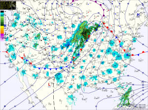
The clouds due to moisture off the Atlantic will persist into the afternoon, keeping high temperatures in the low 70s.
Expect drizzle to develop tonight into tomorrow morning as easterly flow continues. There should be some partial clearing tomorrow afternoon with highs in the low 70s.
As Hurricane Sandy continues its northward trek, it will combine with the high to the north to maintain and enhance the easterly flow in our area. This will lead to a cloudy Saturday with highs in the mid to upper 60s.
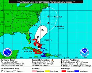
Hurricane Sandy, currently a category 2 storm with winds of 105mph is moving northward towards the Bahamas. This northward movement is expected to continue for the next day or so, bringing Sandy to off the Florida coast. The high pressure off New England will then try to push Sandy northwestward towards the East Coast. At that time, Sandy will be near the Carolina coast while a cold front approaches from the west. This front will initially push Sandy back northeastward and away from the coast.
This is when things get tricky.

Obviously, a landfall near the Delmarva would be worst case scenario for us here in the Mid-Atlantic while a track out to sea would be best. This is an extremely difficult forecast with a potential major impact. What makes it so difficult is that this is an extremely rare occurrence and there many things to take into account. A small change in any of them has drastic changes in the outcome. The timing of the front, the strength and speed of Sandy, and the strength and placement of the high pressure to the north all play into how this develops. Hopefully by later today and tomorrow we will see some consensus build for a better forecast.
Behind the front and no matter the outcome of what happens with Sandy, it will turn much colder as we head into next week. Highs for the first half of the week will struggle to get into the 50s.
Yesterday’s Weather Station Stats:
High Temp: 80.4°
Low Temp: 54.2°
Rain: 0.00″
