Welcome to (Meteorological) Spring!
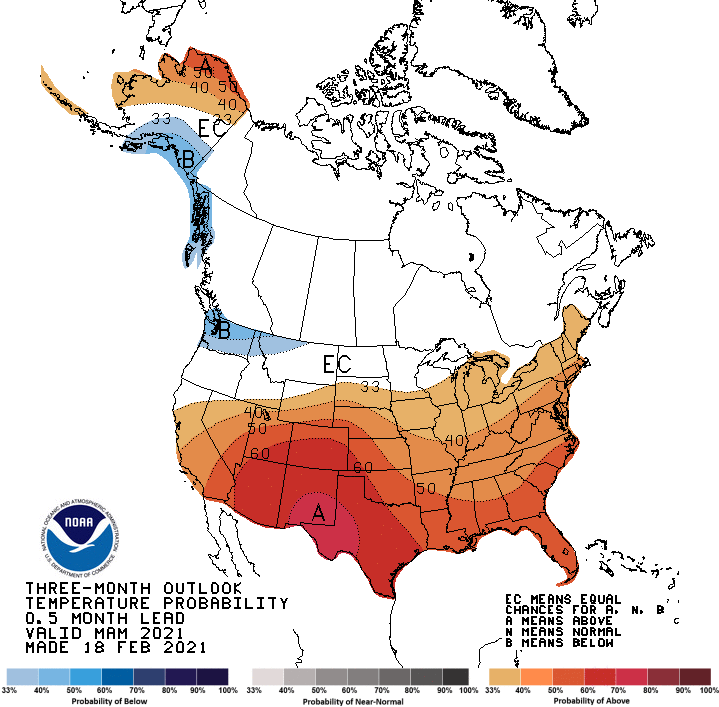
Today is March 1st, and it is the first day of Meteorological Spring! The current 3-month outlooks from the Climate Prediction Center show temperatures likely to be warmer than normal,…

Everything you need to know about the weather in Maryland
A FLOOD WARNING is in effect for portions of Anne Arundel, Baltimore, Howard, Montgomery, and Prince George’s counties.
A COASTAL FLOOD WARNING is in effect for Anne Arundel, Baltimore, Calvert, Prince George’s and St. Mary’s counties.
A COASTAL FLOOD ADVISORY is in effect for Caroline, Dorchester, Queen Annes, Somerset, Talbot and Wicomico counties.
As the area of low pressure that has been slowly moving through the center of the country continues its slow journey northeastward, expect more rainfall and thunderstorms across the area today. The rain will be heavy at times as moisture from the Gulf of Mexico and the Atlantic enhance the rainfall.
The rain will continue through tonight. Thunderstorms will also be possible tonight, especially across southern Maryland. Expect a total 1-2″ of rain today and an additional 1-2″ tonight. Highs today will be in the mid 60s.
A cold front will cross the area tomorrow morning, slowly bringing an end to the rain. Expect partial clearing during the afternoon and highs in the low 70s.
Coastal low pressure remains off the Delmarva coast this morning, continuing to push rainfall into our area. 2-3″ of rain has already fallen across the area, and another 1-2″ is possible today into tonight. Highs today will be in the low 60s.
Periods of rain will continue tonight and into tomorrow morning before tapering to drizzle as the low continues to weaken and slowly move away. Even as the low moves away, the region will remain in northeasterly flow, keeping the clouds and areas of drizzle around through Sunday. Highs both days will be in the low to mid 60s.