
Summary: An area of low pressure will move by to our south today through tonight moving off the coast tomorrow. High pressure will return for the weekend.
A few waves of scattered showers and thunderstorms will affect our area through tomorrow as low pressure slides by to our south. The storms could produce locally heavy rainfall, especially if multiple storms move over the same areas. As a result, a Flash Flood Watch has been issued for all counties west of the bay, except Garrett. Rainfall totals of over an inch are possible by tomorrow evening.
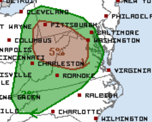
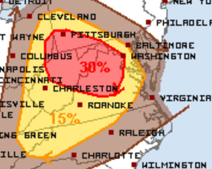
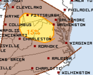
In addition to the flooding potential, the Storm Prediction Center is monitoring the threat for severe weather today. The greatest threat for severe storms is currently mainly west of I-95. Stay alert today and tonight for possible watches and warnings.
Tornado Threat:
Damaging Wind Threat:
Large Hail Threat:
We will clear out tomorrow night as high pressure builds in. Expect mostly sunny skies both Saturday and Sunday with highs around 80 both days.
Temperatures will warm Monday and Tuesday ahead of a cold front that may bring showers and thunderstorms on Tuesday.