
Summary: Low pressure to our southwest continues to push precipitation into our area this morning. Snow will build northward through the morning before changing over to a wintry mix this afternoon and into tonight followed by plain rain tomorrow.
----------------------------------------------------

2:30 update:
As the first batch of precipitation exits the state, round two is moving into southern Maryland now. This batch may start as snow, but should quickly transition to sleet and then eventually freezing rain.
We continue to warm, but areas along and west of I-95 still remain well below freezing and will likely remain so through this evening. The 12z NAM has the I-95 corridor going above freezing around 10pm tonight while areas north and west remain below freezing for another couple of hours:
[slideshow_deploy id=’11177′]
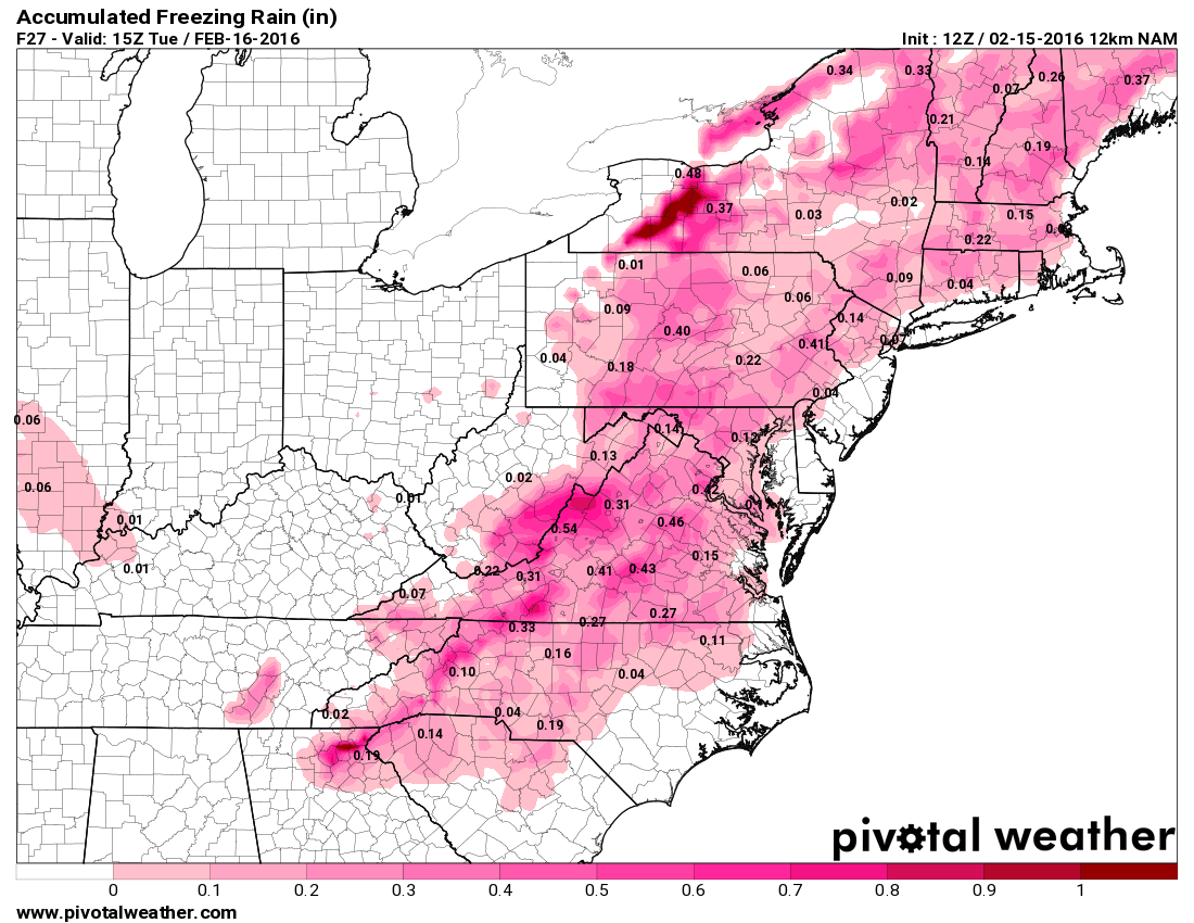
By the time we go above freezing, on average about .1-.15″ of ice has accumulated making for dangerous travel into the overnight:
----------------------------------------------------
----------------------------------------------------

11:30 update:
Snow continues across the state as we move into the lunch hour. Here is an updated snowfall projection:
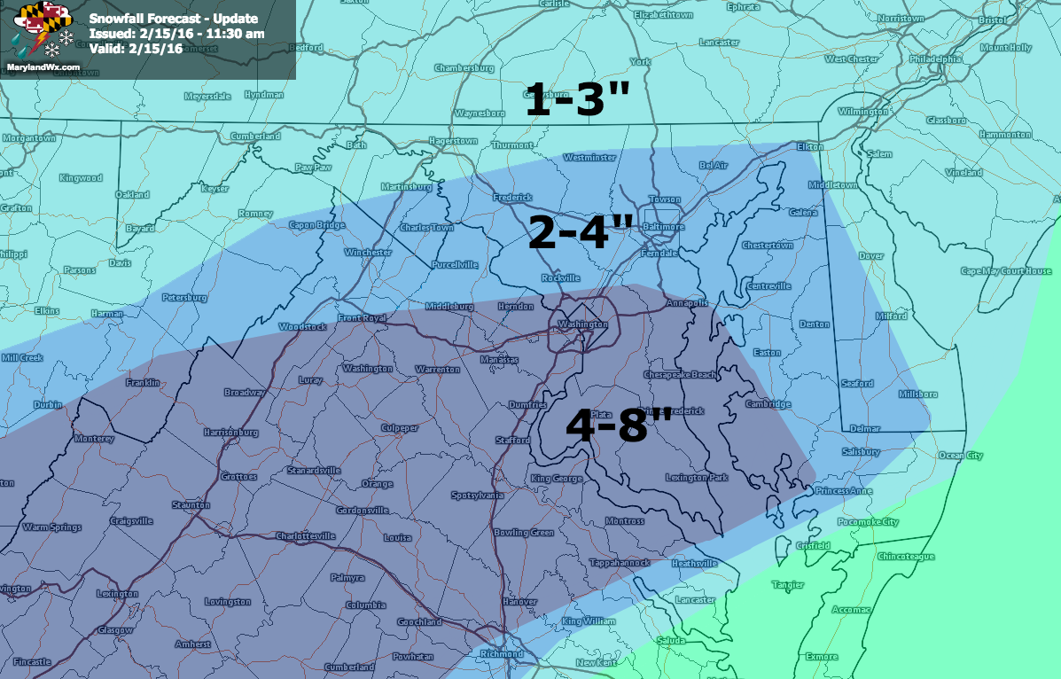
As you can see, it is drastically different than my forecast yesterday. We are seeing more snow than I expected before we head into the afternoon when the transition will occur. Expect another inch or two, mainly across central Maryland. South of there, the precipitation is breaking up and becoming more scattered.
This will continue to progress as we move into the afternoon. Additionally, we will begin to see the transition to a wintry mix, with rain likely across the lower Eastern Shore. The transition will work its way to the northwest into the I-95 corridor this afternoon.
Original post follows...
----------------------------------------------------
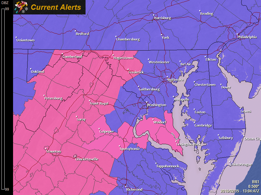
- A Winter Storm Warning is in effect for: Allegany, Calvert, Charles, Frederick, St. Mary's, and Washington counties
- A Winter Weather Advisory is in effect for: Anne Arundel, Baltimore, Baltimore City, Caroline, Carroll, Cecil, Dorchester, Garrett, Harford, Howard, Kent, Montgomery, Prince George's, Queen Anne's, Somerset, Talbot, Wicomico, and Worcester counties
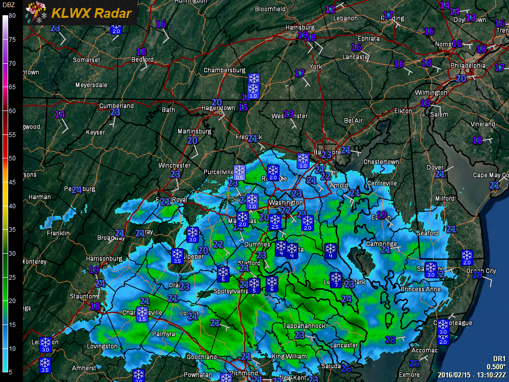
So far, the forecast remains on track *except* for one area: Southern Maryland. While the snow tapered off across the rest of the state, Calvert, Charles and St. Mary’s counties remained in moderate to heavy snow early this morning. As a result, reports of 4 to upwards of 7″ of snow has already fallen and those counties have been upgraded to a Winter Storm Warning.
Southern Maryland and the Eastern Shore will switch over first and will likely see snow change to a wintry mix around noon and then change to plain rain during the afternoon hours.
Further north, the cold air will hold on longer. Areas north of DC and Annapolis will likely remain snow until a little after noon and then transition to a wintry mix. Unlike in Southern Maryland and on the Eastern Shore, there will likely be a prolonged period of sleet and freezing rain that will last into the evening.
Areas north and west of I-95 will likely remain below freezing into tonight with sleet and freezing rain likely until around midnight. Temperatures will then rise above freezing, changing the precip over to plain rain.
Further west, pockets of air in the valleys could remain below freezing into the early morning hours tomorrow before finally changing to rain around day break.
After that, another wave of precipitation will move through, heavy at times tomorrow. All areas will be above freezing and will see plain rain. Areas east of the mountains could see temperatures surge into the low 50s tomorrow afternoon as southerly flow continues to pump in warmer air.
Here is the 06z NAM’s simulated radar 7am this morning through 7pm tomorrow:
[slideshow_deploy id=’11141′]
The system will pull away tomorrow afternoon and evening, ending the rain from southwest to northeast. Some wrap around snow showers will be possible across the mountains before winding down during the evening hours.