
An area of low pressure moved into our region, bumping into a pool of very cold, dense air. Snow developed from west to east during the morning and early afternoon. The snow continued and became heavy at times during the afternoon and into the evening hours. More moisture than anticipated came into the area while the cold air was firmly in place, and as a result, higher snow totals were seen across central and northern Maryland.
The snow changed over to sleet and freezing rain from south to north, becoming all rain last night and into this morning. Some areas, mainly in the mountains and along the Mason-Dixon line never got above freezing and as a result never changed to plain rain.
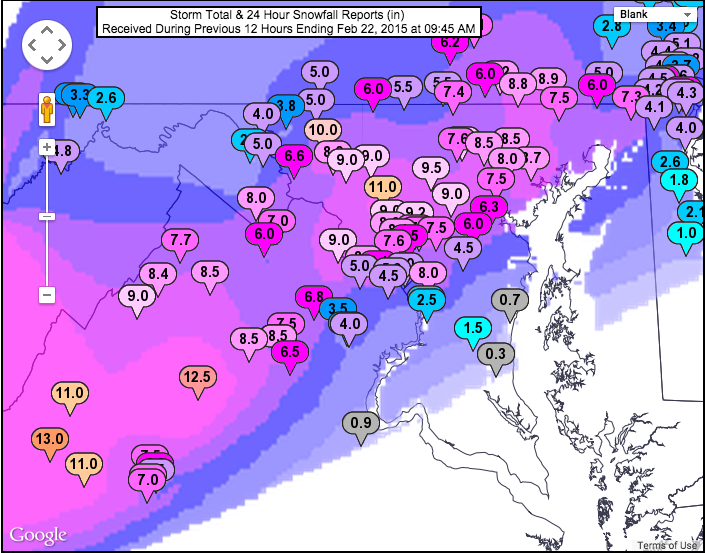
The storm was a definite over-producer in terms of snowfall and easily became the biggest storm of the season with 6.3″ falling at BWI. This brings us to near normal snowfall for the season (18.2″).
(click to enlarge)
Temperatures will rise to around 40° this afternoon all across the state, helping to melt the slop that remains on area roads.
If you can, take this opportunity to clear your driveways and sidewalks to help with standing water, especially considering temperatures will plunge into the low teens to around 20° tonight thanks to a cold front crossing this afternoon. This will cause a major refreeze tonight and tomorrow morning.
Temperatures will not climb much tomorrow, topping out in the low to mid 20s, but ample late-February sunshine should help to continue to melt the dense snowpack. Temps will tumble into the single digits tomorrow night.
Looking ahead, another front will pass through on Tuesday night into Wednesday, bringing in another shot of cold air. There is the possibility that an area of low pressure forms along the front, to our south on Wednesday, possibly bringing a chance of snow Thursday. Right now, that looks like a slight chance but it is something to watch.
Stay up to date with storm information on your favorite social media site!
Follow me on Twitter, Facebook and Google+!