
A Winter Weather Advisory has been issued for:
Allegany, Anne Arundel, Baltimore, Baltimore City, Carroll, Charles, Frederick, Garrett, Harford, Howard, Montgomery and Prince George’s counties.
A Wind Chill Advisory has been issued for:
Eastern Allegany, Anne Arundel, Baltimore, Baltimore City, Calvert, Carroll, Charles, Frederick, Harford, Howard, Montgomery, Prince George’s, and St. Mary’s counties.
A Wind Chill Warning has been issued for:
Western Allegany county.
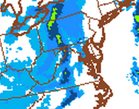
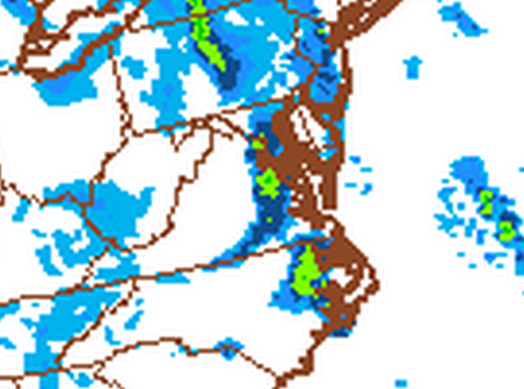
An arctic front will pass through today bringing another round of snow squalls, very cold air and dangerous wind chills to round out the work week.
The most likely time for these squalls to pass through Maryland will be in the 4-8pm timeframe from west to east. These squalls will be very similar to the ones that passed through on Saturday night and will produce brief heavy snowfall, reduced visibility and up to an inch or two of snowfall. Area roadways will become slick and possibly snow covered very quickly, affecting the afternoon commute.
Behind the squalls and the front, strong northwest winds will bring in arctic air tonight through Friday night. Lows tonight will fall into the upper single digits to low teens and will only rise into the mid teens tomorrow.
Tomorrow night, lows will fall to near or below 0 in most spots. With winds continuing to gust to near 25mph, wind chills will fall into the -10s to -20s at times. In these conditions, frostbite can occur in as little as 10 minutes on exposed skin. Avoid being outdoors for any length of time, if possible!
Friday will remain frigid, with highs in the mid teens and winds continuing to gust to near 20mph.
The next storm system will begin to approach the area on Saturday. Out ahead of it, southerly flow will bring in warmer temperatures and as a result, highs on Saturday will be in the low 30s.
Right now, it looks like the system will move by to our northwest, putting us on the warm side of the storm. This would result on a wintry mix changing to rain Saturday afternoon into Sunday. The details of this storm will come into better focus over the next few days. Depending on the exact track of the storm, highs on Sunday could jump into the 40s.
What ever track the storm ends up taking, temperatures will likely fall back into the low 30s for highs and mid teens for lows to begin next week.