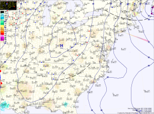
The high will be displaced tomorrow by a clipper system that will pass by to our northwest and drag a cold front through the area. This front will likely be accompanied by light precipitation tomorrow afternoon and evening that will start during or before the evening rush. It will likely be warm enough for a rain/snow or wintry mix during the afternoon hours but may change to light snow showers before ending late tomorrow evening. Highs tomorrow will be in the low to mid 30s.
As high pressure builds in from the northwest on Friday, the departing clipper system will be strengthening off of the New England coast. This will create more strong, gusty winds on Friday as well as scattered snow showers. Winds will likely gust to 35-40mph and highs will top off in the low 30s. Some of the snow showers may briefly whiten the ground in spots, but widespread accumulation is not expected.
Friday night will be clear, windy and cold. Winds will continue to gust to near 30mph and lows will fall down to the low teens.
Saturday will be sunny, breezy and cold. Highs will top out in the mid 20s.
Another storm system will approach on Sunday and likely affect our area Sunday night and Monday. The overall track of this storm is still uncertain. It may pas to our north and west, keeping us on the warm side of the system and keeping our precipitation mostly rain. If it passes to our south and east, we would be on the colder side and could see more wintry precipitation. The details of this system will come into better focus over the next few days but for now, expect more unsettled, messy weather late Sunday into Monday.
