Areas of fog will develop tonight, into tomorrow morning. Skies will remain generally cloudy tomorrow afternoon but it will be warmer as highs push into the mid 70s.
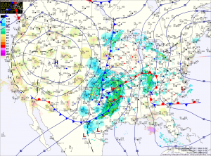
The front will move closer Tuesday night and light showers are possible as we move towards Wednesday morning. The front will be accompanied with deep tropical moisture and as a result, rainfall will pick up in intensity Wednesday.
Expect rain, heavy at times as well as scattered thunderstorms during the afternoon and through the night. Flooding will be possible with the heavy rainfall and damaging winds will be possible in any thunderstorms. Highs will be in the mid 70s.
The front should clear the area by Thursday morning, bringing an end to the rainfall by Thursday afternoon. Highs on Thursday will be around 70.
Expect cooler and drier conditions to end the week and into the weekend.
