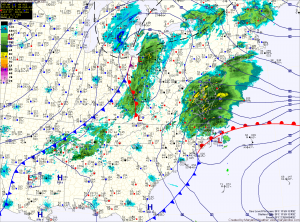
A Winter Weather Advisory remains in effect for counties north and west of I-95. These areas will gradually transition to rain today as highs top out around 40 degrees.
As the storm moves northeast and phases with a secondary low currently over Ohio, it will strengthen rapidly and as it does, colder air will be pulled into our area, possibly changing the rain to snow before ending tonight.
Accumulations of up to an inch are possible, especially over northeast Maryland. Additionally, winds will increase tonight and will gust to near 40mph at times.
Skies will gradually clear tomorrow as high pressure builds in. Winds will continue to be gusty through the day. Highs will be in the upper 30s, but with the wind, it will feel much colder.
Sunday will be mostly sunny with highs around 40.
Another chance of a wintry mix develops late Sunday night into Sunday morning. The mix will change over to plain rain by Monday afternoon and last into Tuesday morning. Highs Monday and Tuesday will be in the mid to upper 40s.
The pattern will remain unsettled next week, with several more chances of precipitation.
Yesterday’s Weather Station Stats:
High Temp: 38.6°
Low Temp: 23.3°
Rain: 0.00″
