
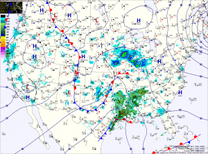
A fast moving area of low pressure will bring light snow to the area tomorrow.
The low is currently over eastern Texas and it will quickly move by to our south during the day tomorrow before it strengthens and moves towards New England.
Expect light snow to develop during the pre-dawn hours tomorrow morning, mixing with or changing to rain in southern Maryland and the lower Eastern Shore.
The rain/snow line will approach the I-95 corridor by tomorrow afternoon and may push into the Baltimore/Washington metro areas.
North and west of I-95 should remain all snow.
The precipitation will wind down tomorrow afternoon as the storm pushes northeastward.
Expected Snowfall Totals by county
2-4 inches (Currently under a Winter Weather Advisory):
Allegany
Northern Baltimore
Carroll
Frederick
Garrett
Washington
1-3 inches:
Southern Baltimore
Baltimore City
Cecil
Harford
Howard
Montgomery
1-2 inches:
Anne Arundel
Kent
Prince Georges
Queen Annes
1 inch or less (mostly rain):
Calvert
Charles
Caroline
Dorchester
Somerset
St. Marys
Talbot
Wicomico
Worcester
After the system moves by, colder air will be dragged into the region. This will set the stage for yet another system that may bring wintry weather to the area late Monday or Tuesday.
Yesterday’s Weather Station Stats:
High Temp: 44.5°
Low Temp: 36.5°
Rain: 0.07″