
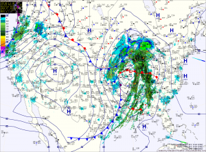
The rain will be heavy at times, accompanied with strong gusty winds. A thunderstorm is possible during the overnight as well.
Winter begins at 6:12 tomorrow morning and the front will be pushing through around that time. Expect wind gusts to near 40mph tomorrow, as temperatures fall from the low 40s into the 30s during the day.
The storm system will continue to strengthen to our northwest. This will continue the gusty winds through the weekend. The gusty winds will allow lake effect snow to continue in the mountains and will likely push rain or snow showers through central Maryland as well during the day tomorrow into tomorrow night.
A Winter Storm Warning is in effect for Garrett and Allegany counties where near blizzard conditions are expected.
Saturday and Sunday will see a mix of clouds and sun, with highs in the low to mid 40s and winds gradually decreasing. Gusts to near 40 on Saturday, decreasing to near 25 on Sunday.
The chilly weather will persist into next week, with highs in the mid 40s on Monday. A weak system may bring showers to the area on Christmas day.
A stronger system may affect the area during the latter half of next week.
Yesterday’s Weather Station Stats:
High Temp: 53.0°
Low Temp: 32.4°
Rain: 0.00″