This blog post will be updated throughout the day today as needed with updates on the forecast and progress of Hurricane Sandy.
Please check this post periodically for updates. I will also update Facebook with any new information.
10:30pm Update:
I wanted to pass along the Special Weather Statement from the National Weather Service:
000
WWUS81 KLWX 290042
SPSLWX
SPECIAL WEATHER STATEMENT
NATIONAL WEATHER SERVICE BALTIMORE MD/WASHINGTON DC
842 PM EDT SUN OCT 28 2012
ANZ530>543-DCZ001-MDZ003>007-009>011-013-014-016>018-501-502-
VAZ025>031-036>040-042-050>057-501>504-WVZ050>053-055-501>506-
290645-
CHESAPEAKE BAY NORTH OF POOLES ISLAND MD-
CHESAPEAKE BAY FROM POOLES ISLAND TO SANDY POINT MD-
CHESAPEAKE BAY FROM SANDY POINT TO NORTH BEACH MD-
CHESAPEAKE BAY FROM NORTH BEACH TO DRUM POINT MD-
CHESAPEAKE BAY FROM DRUM POINT MD TO SMITH POINT VA-
TIDAL POTOMAC FROM KEY BRIDGE TO INDIAN HEAD MD-
TIDAL POTOMAC FROM INDIAN HEAD TO COBB ISLAND MD-
TIDAL POTOMAC FROM COBB ISLAND MD TO SMITH POINT VA-
PATAPSCO RIVER INCLUDING BALTIMORE HARBOR-
CHESTER RIVER TO QUEENSTOWN MD-EASTERN BAY-
CHOPTANK RIVER TO CAMBRIDGE MD AND THE LITTLE CHOPTANK RIVER-
PATUXENT RIVER TO BROOMES ISLAND MD-
TANGIER SOUND AND THE INLAND WATERS SURROUNDING BLOODSWORTH
ISLAND-DISTRICT OF COLUMBIA-WASHINGTON-FREDERICK MD-CARROLL-
NORTHERN BALTIMORE-HARFORD-MONTGOMERY-HOWARD-SOUTHERN BALTIMORE-
PRINCE GEORGES-ANNE ARUNDEL-CHARLES-ST. MARYS-CALVERT-
EXTREME WESTERN ALLEGANY-CENTRAL AND EASTERN ALLEGANY-AUGUSTA-
ROCKINGHAM-SHENANDOAH-FREDERICK VA-PAGE-WARREN-CLARKE-NELSON-
ALBEMARLE-GREENE-MADISON-RAPPAHANNOCK-LOUDOUN-ORANGE-CULPEPER-
PRINCE WILLIAM/MANASSAS/MANASSAS PARK-FAIRFAX-
ARLINGTON/FALLS CHURCH/ALEXANDRIA-STAFFORD-SPOTSYLVANIA-
KING GEORGE-NORTHERN FAUQUIER-SOUTHERN FAUQUIER-WESTERN HIGHLAND-
EASTERN HIGHLAND-HAMPSHIRE-MORGAN-BERKELEY-JEFFERSON-HARDY-
WESTERN GRANT-EASTERN GRANT-WESTERN MINERAL-EASTERN MINERAL-
WESTERN PENDLETON-EASTERN PENDLETON-
INCLUDING THE CITIES OF…WASHINGTON…HAGERSTOWN…FREDERICK…
WESTMINSTER…GAITHERSBURG…COLUMBIA…BALTIMORE…ANNAPOLIS…
WALDORF…ST MARYS CITY…FROSTBURG…CUMBERLAND…STAUNTON…
WAYNESBORO…HARRISONBURG…WINCHESTER…FRONT ROYAL…
CHARLOTTESVILLE…LEESBURG…CULPEPER…MANASSAS…
MANASSAS PARK…FAIRFAX…ALEXANDRIA…FALLS CHURCH…
FREDERICKSBURG…WARRENTON…HIGHTOWN…MONTEREY…MARTINSBURG…
CHARLES TOWN…MOOREFIELD…BAYARD…MOUNT STORM…PETERSBURG…
ELK GARDEN…KEYSER…FORT ASHBY…CIRCLEVILLE…FRANKLIN
842 PM EDT SUN OCT 28 2012
…SANDY LOCAL STATEMENT…
…SANDY TO BRING HURRICANE FORCE WINDS AND FLOOD-PRODUCING HEAVY
RAINFALL TO MUCH OF THE REGION MONDAY THROUGH TUESDAY…
THIS STATEMENT IS FOR THE GREATER BALTIMORE/WASHINGTON
METROPOLITAN AREAS, INCLUDING THE MARYLAND PORTION OF THE
CHESAPEAKE BAY, TIDAL POTOMAC RIVER, MARYLAND FROM THE WESTERN
SHORE OF THE CHESAPEAKE BAY TO GARRETT COUNTY, NORTHERN VIRGINIA,
AND EXTREME EASTERN WEST VIRGINIA. THE OBJECTIVE OF THESE
STATEMENTS IS TO PROVIDE A SINGLE PRODUCT THAT INTEGRATES THE
WARNING PRODUCTS ISSUED BY THE NATIONAL WEATHER SERVICE
BALTIMORE/WASHINGTON WEATHER FORECAST OFFICE.
SANDY LOCAL STATEMENTS WILL BE RELEASED EVERY 6 HOURS THROUGH
WEDNESDAY MORNING AT THE FOLLOWING RELEASE TIMES: 11 PM…5
AM…11 AM…AND 5 PM.
AT 8 PM EDT…THE CENTER OF HURRICANE SANDY WAS LOCATED NEAR
LATITUDE 34.0N…LONGITUDE 70.9W. THIS WAS ABOUT 475 MILES
SOUTHEAST OF WASHINGTON DC. SANDY WAS MOVING NE AT 15 MPH…WITH
MAXIMUM SUSTAINED WINDS OF 75 MPH. SANDY IS FORECAST TO MAKE
LANDFALL ALONG THE NEW JERSEY COAST MONDAY NIGHT. HOWEVER SANDY
WILL IMPACT THE REGION WELL BEFORE IT COMES ASHORE ON MONDAY NIGHT.
SUMMARY OF THREATS
——————
THE MAIN THREATS FOR SANDY WILL BE STRONG WINDS RESULTING IN
WIDESPREAD TREE DAMAGE AND HEAVY RAINS WHICH WILL RESULT IN
EXTENSIVE FLOODING OF LOCAL CREEKS…STREAMS AND SMALL RIVERS.
BLIZZARD CONDITIONS ARE FORECAST IN THE POTOMAC HIGHLANDS AT ELEVATIONS
ABOVE 2500 FEET.
HIGH WINDS
———-
* WINDS WILL INCREASE STEADILY DURING THE DAY ON MONDAY…WITH THE
MAXIMUM WIND GUSTS OCCURRING BETWEEN MONDAY THROUGH TUESDAY
MORNING. GENERALLY…SUSTAINED WINDS OF 30 TO 50 MPH WITH GUSTS
TO 60 MPH CAN BE EXPECTED ACROSS THE ENTIRE AREA.
* HURRICANE FORCE WIND GUSTS TO 70 MPH ARE EXPECTED TO IMPACT A
REGION LOCATED BETWEEN BEL AIR MD…PT LOOKOUT MD…AND
FREDERICK MD. THIS INCLUDES THE GREATER BALTIMORE AND WASHINGTON
METROPOLITAN AREAS.
* COUPLED WITH HEAVY RAINS FROM SANDY…THE HIGH WINDS WILL RESULT
IN SIGNIFICANT TREE DAMAGE AND POWER LINE DAMAGE.
RAINFALL AND FLOODING
———————
* 6 TO 10 INCHES OF RAIN JUST WEST OF THE CHESAPEAKE BAY INCLUDING
THE BALTIMORE METROPOLITAN AREA.
* 4 TO 8 INCHES OF RAIN IS EXPECTED ALONG THE INTERSTATE 270
CORRIDOR INCLUDING THE WASHINGTON DC METROPOLITAN AREA.
* 3 TO 6 INCHES OF RAIN FOR THE POTOMAC HIGHLANDS AND RAPPAHANNOCK
RIVER BASIN INCLUDING CUMBERLAND MD.
* 1 TO 3 INCHES OF RAIN FOR THE NORTHERN SHENANDOAH VALLEY AND
NORTH CENTRAL PIEDMONT OF VIRGINIA SOUTH OF INTERSTATE 66
INCLUDING CHARLOTTESVILLE VA.
* THIS AMOUNT OF RAIN WILL LIKELY RESULT IN EXTENSIVE FLOODING OF
LOCAL STREAMS…CREEKS AND SMALL RIVERS STARTING ON MONDAY
AFTERNOON AND LASTING THROUGH TUESDAY MORNING.
COASTAL FLOODING
—————-
* WITH THE FULL MOON ON MONDAY…ASTRONOMICAL TIDES ARE ALREADY
HIGHER THAN NORMAL. COUNTER TO THE HIGHER THAN NORMAL
ASTRONOMICAL TIDES…STRONG NORTH AND NORTHWESTERLY WINDS ON
MONDAY WILL CAUSE A BLOW-OUT TIDE ALONG THE WESTERN SHORE OF THE
CHESAPEAKE AND THE TIDAL POTOMAC RIVER. EAST FACING BEACHES
ALONG THE TIDAL POTOMAC WILL EXPERIENCE WIND-DRIVEN WAVES THAT
WILL GIVE THE APPEARANCE OF TIDAL FLOODING AND RESULT IN SIMILAR
IMPACTS.
* AS WINDS BECOME SOUTHWESTERLY AROUND DAWN ON TUESDAY…WATER
WILL RETURN BACK INTO THE BAY AND TIDAL POTOMAC AND BEING TO
PILE UP IN THE BAY NORTH OF POOLES ISLAND AND IN THE UPPER
REACHES OF THE TIDAL POTOMAC AND ALONG SOUTH FACING SHORES.
SNOWFALL
——–
* IN THE POTOMAC HIGHLANDS ABOVE 2500 FEET THERE IS THE POTENTIAL
FOR HEAVY WET SNOW.
* THE COMBINATION OF STRONG WIND AND HEAVY WET SNOW WOULD DOWN
TREE LIMBS AND POWER LINES. NEAR BLIZZARD CONDITIONS ARE FORECAST
WITH VISIBILITY NEAR ZERO IN PERIODS OF HEAVY SNOW.
PRECAUTIONARY/PREPAREDNESS ACTIONS
———————————-
* BE PREPARED FOR EXTENDED POWER AND COMMUNICATIONS OUTAGES.
* IF YOU LIVE NEAR LARGE TREES…REMAIN IN THE LOWER LEVEL OF YOUR
HOME OR SEEK SHELTER ELSEWHERE IF POSSIBLE AND RIDE SANDY OUT.
* REFRAIN FROM ANY UNNECESSARY TRAVEL.
* ENSURE LOOSE ITEMS ON YOUR PROPERTY ARE SECURED.
* IF POWER LINES ARE DOWN…STAY AWAY FROM THEM AND REPORT IT TO YOUR
LOCAL ELECTRICAL UTILITY COMPANY.
* IF YOU SHOULD HAVE EMERGENCY TRAVEL…IF YOU COME UPON FLOODED
ROADWAYS DO NOT ATTEMPT TO CROSS SUBMERGED ROADWAYS. TURN AROUND
AND DONT DROWN.
* IF YOU USE A PORTABLE POWER GENERATOR…PLEASE FOLLOW
MANUFACTURERS INSTRUCTIONS AND ENSURE THAT IT IS PROPERLY
VENTILATED.
* DO NOT USE CHARCOAL GRILLS IN ENCLOSED AREAS.
* MARINERS SHOULD ENSURE THAT THERE IS ENOUGH SLACK LINE IN THEIR
BOAT`S MOORINGS TO ACCEPT A BLOW OUT TIDE ON MONDAY AND MONDAY
NIGHT.
* PERIODICALLY CHECK ON YOUR ELDERLY NEIGHBORS AND FAMILY MEMBERS
TO ENSURE THEY ARE SAFE.
* PEOPLE SHOULD HAVE ALREADY HAVE FILLED THEIR PRESCRIPTIONS AND
HAVE A FULL TANK OF GAS. IF NOT THESE PREPARATIONS SHOULD BE
RUSHED TO COMPLETION THIS SUNDAY EVENING.
FOR ADDITIONAL PRECAUTIONARY AND PREPAREDNESS INFORMATION…
PLEASE REFER TO THE DETAILED RECOMMENDATIONS RELATIVE TO YOUR
LOCATION AS FURTHER DESCRIBED BY YOUR LOCAL NATIONAL WEATHER
SERVICE OFFICE AND LOCAL EMERGENCY MANAGEMENT.
&&
.NEXT UPDATE…
THE NEXT LOCAL STATEMENT WILL BE ISSUED BY THE NATIONAL WEATHER
SERVICE BALTIMORE/WASHINGTON WEATHER FORECAST OFFICE AT 11 PM EDT OR
SOONER IF CONDITIONS WARRANT.
$$
LEE
Previous update is below.
———————————————————————
5:00pm Update:
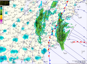
-Flood Watch for the entire state
-Coastal Flood Advisory/Watch for Western shore of Bay
-Coastal Flood Watch for counties along the Potomac
-Coastal Flood Warning for the Atlantic Beaches
-High Wind Warning for entire state
-Blizzard Warning for Garrett County
-Hurricane Force Wind Warning for the Chesapeake Bay and Atlantic Coast
Sandy is beginning to affect central Maryland as light rain continues to push across the Bay. Winds are also beginning to increase slightly and both will continue to build into the night.
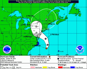
Maximum Sustained Winds: 75mph
Minimum Pressure: 952mb (28.11″)
Moving NE @ 15mph
Tropical Storm force winds extend 520 miles from the center.
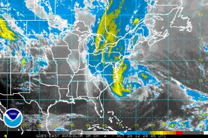
This track also puts the center between York and Harrisburg, PA by 2pm Tuesday.
It will be during its trek from New Jersey to Pennsylvania that we will experience the strongest winds. Winds will gust over 65mph from late Monday morning into Tuesday afternoon.
The good news is that it will push into central New York state by 2pm Wednesday and out of our area.
Previous update is below.
———————————————————————
2:00pm Update:
Current Advisories:
-Flood Watch for the entire state
-Coastal Flood Advisory/Watch for Western shore of Bay
-Coastal Flood Watch for counties along the Potomac
-Coastal Flood Warning for the Atlantic Beaches
-High Wind Warning for entire state
-Winter Storm Watch for Garrett County
-Hurricane Force Wind Warning for the Chesapeake Bay and Atlantic Coast
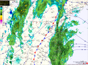
The outer edge of the storm has continued to push westward and is now slowly crossing the Bay and will gradually overspread central Maryland.
Tropical Storm force winds have reached the mouth of the Chesapeake and will continue to push northward into our area.
Conditions will continue to deteriorate this afternoon and tonight. Expect winds to increase and gust over hurricane strength by tomorrow morning. These winds will last through the day tomorrow and through most of the day on Tuesday before they begin to weaken Tuesday night.
Previous update is below.
———————————————————————
9:00am Update:
Current Advisories:
-Flood Watch for the entire state
-Coastal Flood Advisory/Watch for Western shore of Bay
-Coastal Flood Watch for counties along the Potomac
-Coastal Flood Warning for the Atlantic Beaches
-High Wind Warning for entire state
-Winter Storm Watch for Garrett County
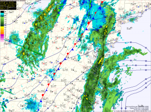
The outer bands of Sandy have overspread the Delmarva and are approaching the Bay. Ocean City is experiencing sustained winds from the northeast at 20mph with gusts to 36mph.
BWI is reporting winds out of the northeast at 15, gusting to 20.
Expect the wind and rain to gradually increase today and tonight with the worst of it expected tomorrow into Tuesday.
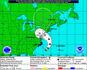
Maximum Sustained Winds: 75mph
Minimum Pressure: 951mb (28.08″) Dropped 9mb in 3hrs
Moving NE @ 10mph
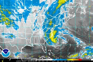
Sandy is expected to continue to move to the NE today before turning back towards the NW late tonight into Monday and is expected to make landfall near central New Jersey.
Here is the National Weather Service Forecast for Central Maryland:
Today
Scattered showers before 2pm, then rain after 2pm. High near 61. North wind 13 to 15 mph. Chance of precipitation is 90%. New precipitation amounts between a tenth and quarter of an inch possible.
Tonight
Rain. The rain could be heavy at times. Low around 51. Breezy, with a north wind 16 to 21 mph, with gusts as high as 31 mph. Chance of precipitation is 100%. New precipitation amounts between a half and three quarters of an inch possible.
Monday
Rain. The rain could be heavy at times. High near 53. Very windy, with a north wind 23 to 33 mph increasing to 33 to 43 mph in the afternoon. Winds could gust as high as 60 mph. Chance of precipitation is 100%. New precipitation amounts between 2 and 3 inches possible.
Monday Night
Rain. The rain could be heavy at times. Low around 43. Very windy, with a north wind around 45 mph, with gusts as high as 65 mph. Chance of precipitation is 100%. New precipitation amounts between 2 and 3 inches possible.
Tuesday
Showers. High near 51. Windy, with a southwest wind 37 to 39 mph, with gusts as high as 55 mph. Chance of precipitation is 90%. New precipitation amounts between 1 and 2 inches possible.
Tuesday Night
A chance of showers. Cloudy, with a low around 42. Windy. Chance of precipitation is 50%. New precipitation amounts between a quarter and half of an inch possible.
Wednesday
A chance of showers. Mostly cloudy, with a high near 54. Chance of precipitation is 30%.
