Scattered showers and thunderstorms will develop this afternoon ahead of a cold front. Some of these storms could be severe with large hail, gusty winds and heavy rain. The front will move through tonight, then stall south of the area allowing for a slight chance of storms tomorrow, especially in southern Maryland.
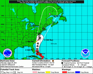
The bigger story continues to be Hurricane Irene. Latest thinking from the National Hurricane Center has shifted the forecast track back towards the west. Early thoughts were that a cold front would help steer Irene off the coast, but now it appears that the storm will not be picked up by that front, allowing it to ride up the coast.
This could change again, but as of right now, at 2am Sunday, the NHC has Irene on top of Virginia Beach with 105mph winds and moving northeast. This would take the storm just off Ocean City and into Massachusetts by Monday morning.
Remember, you can always get the latest information from the NHC by clicking on the map at the top of the left toolbar. The NHC updates their forecast every 3 hours.

